Distance between Monte Verde and Franca
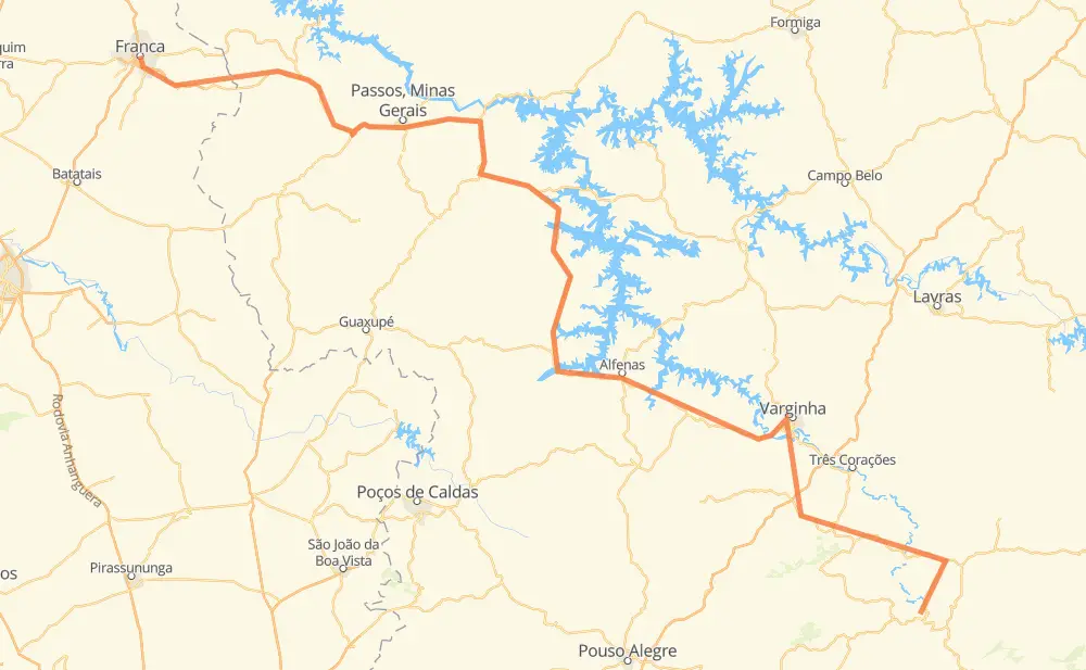
The distance from Monte Verde to Franca is 440 kilometers by road including 40 kilometers on motorways. Road takes approximately 5 hours and 13 minutes and goes through Taboão, Cambuquira, Campanha, Rio Verde, Elói Mendes, Paraguaçu and Areado.
| Shortest distance by air | 300 km ✈️ |
| Car route length | 440 km 🚗 |
| Driving time | 5 h 13 min |
| Fuel amount | 35.2 L |
| Fuel cost | 52.5 GBP |
| Point | Distance | Time | Fuel | |
| Monte Verde | 0 km | 00 min | 0.0 L | |
|
BR-383 28 km, 22 min
|
||||
| Taboão | 28 km | 22 min | 1.7 L | |
|
BR-267 36 km, 26 min
|
||||
| Cambuquira | 64 km | 48 min | 5.0 L | |
|
BR-267 12 km, 08 min
|
||||
| Campanha | 76 km | 57 min | 5.5 L | |
|
BR-267 BR-381 41 km, 27 min
|
||||
| Rio Verde | 117 km | 1 h 24 min | 9.3 L | |
|
BR-491 24 km, 17 min
|
||||
| Elói Mendes | 142 km | 1 h 42 min | 10.5 L | |
|
BR-491 16 km, 12 min
|
||||
| Paraguaçu | 158 km | 1 h 54 min | 12.2 L | |
|
BR-491 57 km, 38 min
|
||||
| Areado | 215 km | 2 h 33 min | 16.8 L | |
|
MG-184 17 km, 12 min
|
||||
| Alterosa | 232 km | 2 h 45 min | 17.9 L | |
|
MG-184 31 km, 23 min
|
||||
| Carmo do Rio Claro | 263 km | 3 h 09 min | 20.8 L | |
|
MG-184 MG-050 178 km, 2 h 03 min
|
||||
| -20.53818, -47.40098 | 440 km | 5 h 12 min | 35.2 L | |
Hotels of Franca
Frequently Asked Questions
How much does it cost to drive from Monte Verde to Franca?
Fuel cost: 52.5 GBP
This fuel cost is calculated as: (Route length 440 km / 100 km) * (Fuel consumption 8 L/100 km) * (Fuel price 1.49 GBP / L)
You can adjust fuel consumption and fuel price here.
How long is a car ride from Monte Verde to Franca?
Driving time: 5 h 13 min
This time is calculated for driving at the maximum permitted speed, taking into account traffic rules restrictions.
- 17 km with a maximum speed 110 km/h = 9 min
- 23 km with a maximum speed 100 km/h = 13 min
- 138 km with a maximum speed 96 km/h = 1 h 26 min
- 247 km with a maximum speed 80 km/h = 3 h 5 min
- 8 km with a maximum speed 60 km/h = 8 min
- 6 km with a maximum speed 40 km/h = 9 min
The calculated driving time does not take into account intermediate stops and traffic jams.
How far is Monte Verde to Franca by land?
The distance between Monte Verde and Franca is 440 km by road including 40 km on motorways.
Precise satellite coordinates of highways were used for this calculation. The start and finish points are the centers of Monte Verde and Franca respectively.
How far is Monte Verde to Franca by plane?
The shortest distance (air line, as the crow flies) between Monte Verde and Franca is 300 km.
This distance is calculated using the Haversine formula as a great-circle distance between two points on the surface of a sphere. The start and finish points are the centers of Monte Verde and Franca respectively. Actual distance between airports may be different.
How many hours is Monte Verde from Franca by plane?
Boeing 737 airliner needs 22 min to cover the distance of 300 km at a cruising speed of 800 km/h.
Small plane "Cessna 172" needs 1 h 21 min to flight this distance at average speed of 220 km/h.
This time is approximate and do not take into account takeoff and landing times, airport location and other real world factors.
How long is a helicopter ride from Monte Verde to Franca?
Fast helicopter "Eurocopter AS350" or "Hughes OH-6 Cayuse" need 1 h 15 min to cover the distance of 300 km at a cruising speed of 240 km/h.
Popular "Robinson R44" needs 1 h 25 min to flight this distance at average speed of 210 km/h.
This time is approximate and do not take into account takeoff and landing times, aerodrome location and other real world factors.
What city is halfway between Monte Verde and Franca?
The halfway point between Monte Verde and Franca is Areado. It is located about 5 km from the exact midpoint by road.
The distance from Areado to Monte Verde is 215 km and driving will take about 2 h 33 min. The road between Areado and Franca has length 225 km and will take approximately 2 h 39 min.
The other cities located close to halfway point:
Where is Monte Verde in relation to Franca?
Monte Verde is located 300 km south-east of Franca.
Monte Verde has geographic coordinates: latitude -22.10596, longitude -45.0507.
Franca has geographic coordinates: latitude -20.53818, longitude -47.40098.
Which highway goes from Monte Verde to Franca?
The route from Monte Verde to Franca follows BR-491.
Other minor sections pass along the road:
- BR-267: 63 km
- MG-184: 58 km
- MG-050: 41 km
- SP-345: 32 km
- MG-344: 26 km
- MG-444: 24 km
- MG-446: 21 km
- BR-383: 20 km
- MG-167: 20 km
- BR-265: 19 km
- MGC-265: 18 km
- BR-381: 17 km