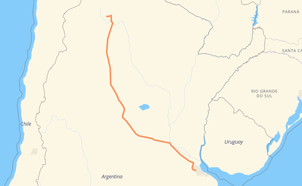
Distance between Moreno and Salta
The distance from Moreno to Salta is 1,546 kilometers by road including 682 kilometers on motorways. Road takes approximately 15 hours and 33 minutes and goes through Rosario, Córdoba, San Miguel de Tucumán, La Reja, Francisco Álvarez, Los Aromos and Barrio Parque Irigoyen.
| Shortest distance by air | 1,268 km ✈️ |
| Car route length | 1,546 km 🚗 |
| Driving time | 15 h 33 min |
| Fuel amount | 123.7 L |
| Fuel cost | 184.2 GBP |
| Point | Distance | Time | Fuel | |
| Moreno | 0 km | 00 min | 0.0 L | |
|
RP25 5 km, 03 min
|
||||
| La Reja | 5 km | 03 min | 0.1 L | |
|
RN7 4 km, 01 min
|
||||
| Francisco Álvarez | 9 km | 05 min | 0.7 L | |
|
RN7 3 km, 01 min
|
||||
| Los Aromos | 12 km | 07 min | 0.7 L | |
|
RN7 7 km, 03 min
|
||||
| Barrio Parque Irigoyen | 18 km | 11 min | 1.3 L | |
|
RN7 RP6 26 km, 18 min
|
||||
| Parque Sakura | 45 km | 29 min | 3.3 L | |
|
RP6 RN9 246 km, 2 h 16 min
|
||||
| Rosario | 291 km | 2 h 46 min | 22.6 L | |
|
RNA008 RN9 393 km, 3 h 33 min
|
||||
| Córdoba | 683 km | 6 h 19 min | 52.9 L | |
|
RN9 RN157 562 km, 6 h 00 min
|
||||
| San Miguel de Tucumán | 1,246 km | 12 h 20 min | 98.5 L | |
|
RN9 300 km, 3 h 13 min
|
||||
| Salta | 1,546 km | 15 h 33 min | 123.0 L | |
Hotels of Salta
Frequently Asked Questions
How much does it cost to drive from Moreno to Salta?
Fuel cost: 184.2 GBP
This fuel cost is calculated as: (Route length 1,546 km / 100 km) * (Fuel consumption 8 L/100 km) * (Fuel price 1.49 GBP / L)
You can adjust fuel consumption and fuel price here.
How long is a car ride from Moreno to Salta?
Driving time: 15 h 33 min
This time is calculated for driving at the maximum permitted speed, taking into account traffic rules restrictions.
- 610 km with a maximum speed 112 km/h = 5 h 26 min
- 25 km with a maximum speed 110 km/h = 13 min
- 26 km with a maximum speed 100 km/h = 15 min
- 767 km with a maximum speed 96 km/h = 7 h 59 min
- 89 km with a maximum speed 80 km/h = 1 h 7 min
- 23 km with a maximum speed 60 km/h = 22 min
- 5 km with a maximum speed 40 km/h = 7 min
The calculated driving time does not take into account intermediate stops and traffic jams.
How far is Moreno to Salta by land?
The distance between Moreno and Salta is 1,546 km by road including 682 km on motorways.
Precise satellite coordinates of highways were used for this calculation. The start and finish points are the centers of Moreno and Salta respectively.
How far is Moreno to Salta by plane?
The shortest distance (air line, as the crow flies) between Moreno and Salta is 1,268 km.
This distance is calculated using the Haversine formula as a great-circle distance between two points on the surface of a sphere. The start and finish points are the centers of Moreno and Salta respectively. Actual distance between airports may be different.
How many hours is Moreno from Salta by plane?
Boeing 737 airliner needs 1 h 35 min to cover the distance of 1,268 km at a cruising speed of 800 km/h.
Small plane "Cessna 172" needs 5 h 45 min to flight this distance at average speed of 220 km/h.
This time is approximate and do not take into account takeoff and landing times, airport location and other real world factors.
How long is a helicopter ride from Moreno to Salta?
Fast helicopter "Eurocopter AS350" or "Hughes OH-6 Cayuse" need 5 h 17 min to cover the distance of 1,268 km at a cruising speed of 240 km/h.
Popular "Robinson R44" needs 6 h 2 min to flight this distance at average speed of 210 km/h.
This time is approximate and do not take into account takeoff and landing times, aerodrome location and other real world factors.
What city is halfway between Moreno and Salta?
The halfway point between Moreno and Salta is Villa Gutiérrez. It is located about 1 km from the exact midpoint by road.
The distance from Villa Gutiérrez to Moreno is 774 km and driving will take about 7 h 19 min. The road between Villa Gutiérrez and Salta has length 771 km and will take approximately 8 h 14 min.
The other cities located close to halfway point:
Where is Moreno in relation to Salta?
Moreno is located 1,268 km south-east of Salta.
Moreno has geographic coordinates: latitude -34.63966, longitude -58.78983.
Salta has geographic coordinates: latitude -24.78938, longitude -65.41019.
Which highway goes from Moreno to Salta?
The route from Moreno to Salta follows RN9, RN157, RN60, RN34.
Other minor sections pass along the road:
- RP6: 48 km
- RN7: 23 km
- RN2V9: 15 km
- RNA019: 12 km
- RNA008: 9 km
- RN38: 6 km