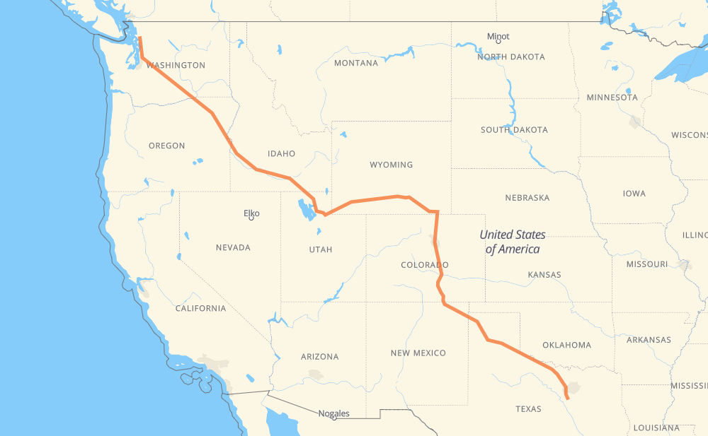
The distance from Mount Vernon to Grandview is 3,506 kilometers by road including 2,717 kilometers on motorways. Road takes approximately 34 hours and 4 minutes and goes through Everett, Bellevue, Yakima, Ogden, Rock Springs, Laramie and Cheyenne.
How much does it cost to drive from Mount Vernon to Grandview?
Fuel cost:
417.9 GBP
This fuel cost is calculated as: (Route length 3,506 km / 100 km) * (Fuel consumption 8 L/100 km) * (Fuel price 1.49 GBP / L)
You can adjust fuel consumption and fuel price here.
How long is a car ride from Mount Vernon to Grandview?
Driving time:
34 h 4 min
This time is calculated for driving at the maximum permitted speed, taking into account traffic rules restrictions.
1,959 km with a maximum speed 112 km/h = 17 h 29 min
246 km with a maximum speed 105 km/h = 2 h 20 min
229 km with a maximum speed 100 km/h = 2 h 17 min
125 km with a maximum speed 97 km/h = 1 h 17 min
578 km with a maximum speed 96 km/h = 6 h 1 min
57 km with a maximum speed 89 km/h = 38 min
6 km with a maximum speed 80 km/h = 4 min
288 km with a maximum speed 80 km/h = 3 h 35 min
6 km with a maximum speed 72 km/h = 5 min
2 km with a maximum speed 64 km/h = 1 min
2 km with a maximum speed 50 km/h = 2 min
6 km with a maximum speed 48 km/h = 7 min
The calculated driving time does not take into account intermediate stops and traffic jams.
How far is Mount Vernon to Grandview by land?
The distance between Mount Vernon and Grandview is 3,506 km by road including 2,717 km on motorways.
Precise satellite coordinates of highways were used for this calculation. The start and finish points are the centers of Mount Vernon and Grandview respectively.
How far is Mount Vernon to Grandview by plane?
The shortest distance (air line, as the crow flies) between Mount Vernon and Grandview is 2,765 km.
This distance is calculated using the Haversine formula as a great-circle distance between two points on the surface of a sphere. The start and finish points are the centers of Mount Vernon and Grandview respectively. Actual distance between airports may be different.
How many hours is Mount Vernon from Grandview by plane?
Boeing 737 airliner needs 3 h 27 min to cover the distance of 2,765 km at a cruising speed of 800 km/h.
Small plane "Cessna 172" needs 12 h 34 min to flight this distance at average speed of 220 km/h.
This time is approximate and do not take into account takeoff and landing times, airport location and other real world factors.
How long is a helicopter ride from Mount Vernon to Grandview?
Fast helicopter "Eurocopter AS350" or "Hughes OH-6 Cayuse" need 11 h 31 min to cover the distance of 2,765 km at a cruising speed of 240 km/h.
Popular "Robinson R44" needs 13 h 10 min to flight this distance at average speed of 210 km/h.
This time is approximate and do not take into account takeoff and landing times, aerodrome location and other real world factors.
What city is halfway between Mount Vernon and Grandview?
The halfway point between Mount Vernon and Grandview is Red Desert.
The distance from Red Desert to Mount Vernon is 1,753 km and driving will take about 16 h 33 min. The road between Red Desert and Grandview has length 1,753 km and will take approximately 17 h 30 min.
The other cities located close to halfway point:
Wamsutter is in 1,767 km from Mount Vernon and 1,739 km from Grandview
Creston Junction is in 1,782 km from Mount Vernon and 1,724 km from Grandview
Point of Rocks is in 1,691 km from Mount Vernon and 1,815 km from Grandview
Where is Mount Vernon in relation to Grandview?
Mount Vernon is located 2,765 km north-west of Grandview.
Mount Vernon has geographic coordinates: latitude 48.42005, longitude -122.32642.
Grandview has geographic coordinates: latitude 32.27042, longitude -97.17918.
Which highway goes from Mount Vernon to Grandview?
The route from Mount Vernon to Grandview follows I 84, US 30, I 80, US 287, I 25, US 87, I 90, I 82, US 26, US 64.