Distance between Musgrave Harbour NL and Lyndon Station WI
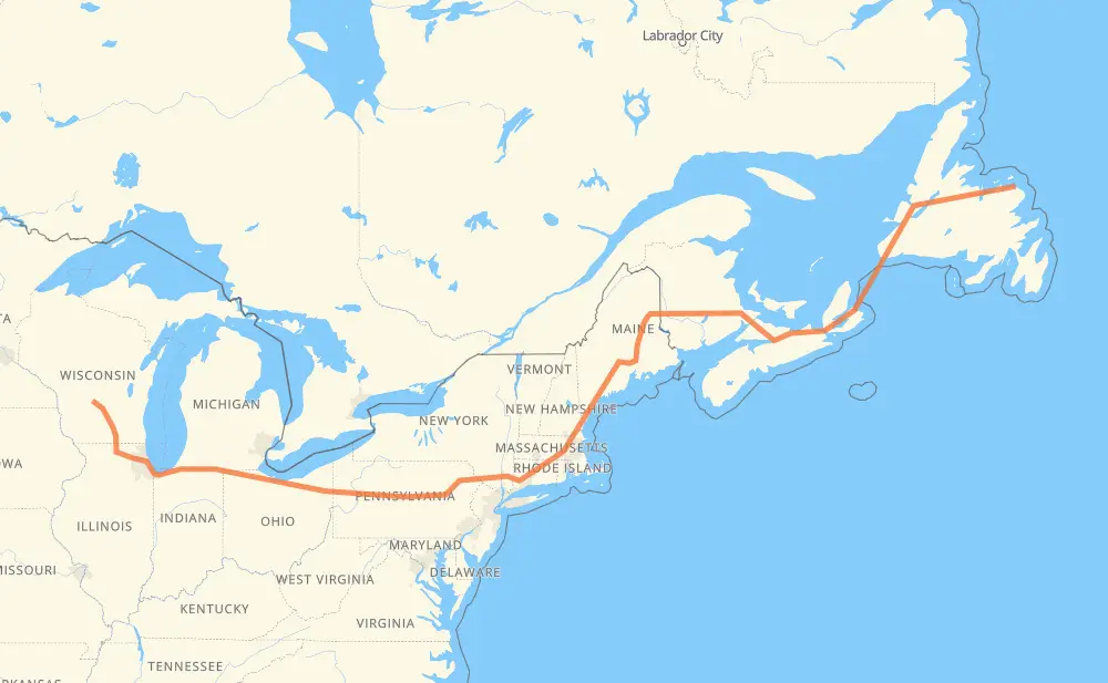
The distance from Musgrave Harbour to Lyndon Station is 4,078 kilometers by road including 3,089 kilometers on motorways. Road takes approximately 46 hours and 24 minutes and goes through Corner Brook, Moncton, Fredericton, Bangor, Waterville, Augusta and Portland.
How much does it cost to drive from Musgrave Harbour to Lyndon Station?
Fuel cost:
486.1 GBP
This fuel cost is calculated as: (Route length 4,078 km / 100 km) * (Fuel consumption 8 L/100 km) * (Fuel price 1.49 GBP / L)
You can adjust fuel consumption and fuel price here.
How long is a car ride from Musgrave Harbour to Lyndon Station?
Driving time:
46 h 24 min
This time is calculated for driving at the maximum permitted speed, taking into account traffic rules restrictions.
1,659 km with a maximum speed 112 km/h = 14 h 48 min
510 km with a maximum speed 110 km/h = 4 h 38 min
511 km with a maximum speed 105 km/h = 4 h 53 min
207 km with a maximum speed 100 km/h = 2 h 4 min
10 km with a maximum speed 97 km/h = 6 min
699 km with a maximum speed 96 km/h = 7 h 17 min
3 km with a maximum speed 90 km/h = 2 min
82 km with a maximum speed 89 km/h = 55 min
14 km with a maximum speed 80 km/h = 10 min
191 km with a maximum speed 80 km/h = 2 h 22 min
5 km with a maximum speed 72 km/h = 4 min
5 km with a maximum speed 70 km/h = 4 min
2 km with a maximum speed 50 km/h = 2 min
177 km with a maximum speed 20 km/h = 8 h 52 min
The calculated driving time does not take into account intermediate stops and traffic jams.
How far is Musgrave Harbour to Lyndon Station by land?
The distance between Musgrave Harbour and Lyndon Station is 4,078 km by road including 3,089 km on motorways.
Precise satellite coordinates of highways were used for this calculation. The start and finish points are the centers of Musgrave Harbour and Lyndon Station respectively.
How far is Musgrave Harbour to Lyndon Station by plane?
The shortest distance (air line, as the crow flies) between Musgrave Harbour and Lyndon Station is 2,793 km.
This distance is calculated using the Haversine formula as a great-circle distance between two points on the surface of a sphere. The start and finish points are the centers of Musgrave Harbour and Lyndon Station respectively. Actual distance between airports may be different.
How many hours is Musgrave Harbour from Lyndon Station by plane?
Boeing 737 airliner needs 3 h 29 min to cover the distance of 2,793 km at a cruising speed of 800 km/h.
Small plane "Cessna 172" needs 12 h 41 min to flight this distance at average speed of 220 km/h.
This time is approximate and do not take into account takeoff and landing times, airport location and other real world factors.
How long is a helicopter ride from Musgrave Harbour to Lyndon Station?
Fast helicopter "Eurocopter AS350" or "Hughes OH-6 Cayuse" need 11 h 38 min to cover the distance of 2,793 km at a cruising speed of 240 km/h.
Popular "Robinson R44" needs 13 h 18 min to flight this distance at average speed of 210 km/h.
This time is approximate and do not take into account takeoff and landing times, aerodrome location and other real world factors.
What city is halfway between Musgrave Harbour and Lyndon Station?
The halfway point between Musgrave Harbour and Lyndon Station is Kennebunk. It is located about 5 km from the exact midpoint by road.
The distance from Kennebunk to Musgrave Harbour is 2,034 km and driving will take about 27 h 16 min. The road between Kennebunk and Lyndon Station has length 2,044 km and will take approximately 19 h 8 min.
The other cities located close to halfway point:
Wells is in 2,050 km from Musgrave Harbour and 2,029 km from Lyndon Station
Biddeford is in 2,028 km from Musgrave Harbour and 2,051 km from Lyndon Station
Saco is in 2,015 km from Musgrave Harbour and 2,063 km from Lyndon Station
Where is Musgrave Harbour in relation to Lyndon Station?
Musgrave Harbour is located 2,793 km east of Lyndon Station.
Musgrave Harbour has geographic coordinates: latitude 49.45116, longitude -53.95111.
Lyndon Station has geographic coordinates: latitude 43.7122, longitude -89.89957.
Which highway goes from Musgrave Harbour to Lyndon Station?
The route from Musgrave Harbour to Lyndon Station follows I 80, I 90, 1, I 95, TCH, I 84, 2, NS 104, I 39, NS 105, I 94, I 495.