Distance between Naperville IL and Kanarraville UT
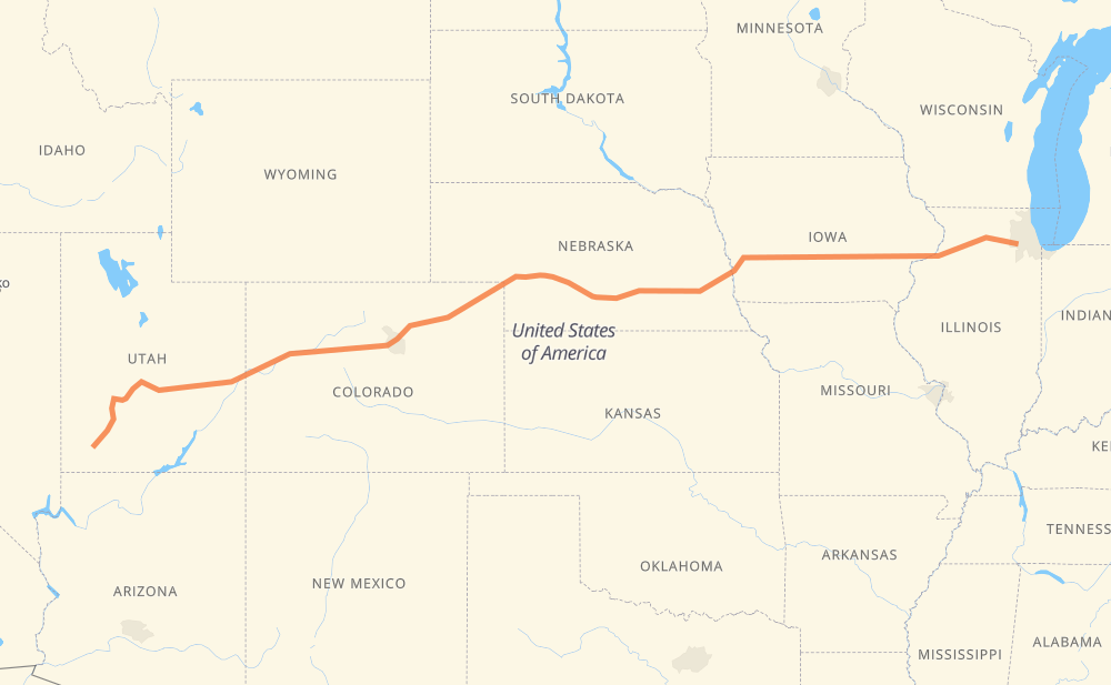
The distance from Naperville to Kanarraville is 2,515 kilometers by road including 2,501 kilometers on motorways. Road takes approximately 23 hours and 10 minutes and goes through Davenport, Iowa City, Omaha, Lincoln, North Platte, Denver and Vail.
How much does it cost to drive from Naperville to Kanarraville?
Fuel cost:
299.8 GBP
This fuel cost is calculated as: (Route length 2,515 km / 100 km) * (Fuel consumption 8 L/100 km) * (Fuel price 1.49 GBP / L)
You can adjust fuel consumption and fuel price here.
How long is a car ride from Naperville to Kanarraville?
Driving time:
23 h 10 min
This time is calculated for driving at the maximum permitted speed, taking into account traffic rules restrictions.
1,987 km with a maximum speed 112 km/h = 17 h 44 min
266 km with a maximum speed 105 km/h = 2 h 32 min
119 km with a maximum speed 100 km/h = 1 h 11 min
37 km with a maximum speed 97 km/h = 23 min
3 km with a maximum speed 96 km/h = 2 min
8 km with a maximum speed 89 km/h = 5 min
8 km with a maximum speed 80 km/h = 5 min
85 km with a maximum speed 80 km/h = 1 h 4 min
1 km with a maximum speed 56 km/h = 1 min
The calculated driving time does not take into account intermediate stops and traffic jams.
How far is Naperville to Kanarraville by land?
The distance between Naperville and Kanarraville is 2,515 km by road including 2,501 km on motorways.
Precise satellite coordinates of highways were used for this calculation. The start and finish points are the centers of Naperville and Kanarraville respectively.
How far is Naperville to Kanarraville by plane?
The shortest distance (air line, as the crow flies) between Naperville and Kanarraville is 2,187 km.
This distance is calculated using the Haversine formula as a great-circle distance between two points on the surface of a sphere. The start and finish points are the centers of Naperville and Kanarraville respectively. Actual distance between airports may be different.
How many hours is Naperville from Kanarraville by plane?
Boeing 737 airliner needs 2 h 44 min to cover the distance of 2,187 km at a cruising speed of 800 km/h.
Small plane "Cessna 172" needs 9 h 56 min to flight this distance at average speed of 220 km/h.
This time is approximate and do not take into account takeoff and landing times, airport location and other real world factors.
How long is a helicopter ride from Naperville to Kanarraville?
Fast helicopter "Eurocopter AS350" or "Hughes OH-6 Cayuse" need 9 h 6 min to cover the distance of 2,187 km at a cruising speed of 240 km/h.
Popular "Robinson R44" needs 10 h 24 min to flight this distance at average speed of 210 km/h.
This time is approximate and do not take into account takeoff and landing times, aerodrome location and other real world factors.
What city is halfway between Naperville and Kanarraville?
The halfway point between Naperville and Kanarraville is Ogallala. It is located about 34 km from the exact midpoint by road.
The distance from Ogallala to Naperville is 1,223 km and driving will take about 11 h 5 min. The road between Ogallala and Kanarraville has length 1,292 km and will take approximately 12 h 4 min.
The other cities located close to halfway point:
North Platte is in 1,161 km from Naperville and 1,353 km from Kanarraville
Sterling is in 1,370 km from Naperville and 1,145 km from Kanarraville
Brush is in 1,426 km from Naperville and 1,089 km from Kanarraville
Where is Naperville in relation to Kanarraville?
Naperville is located 2,187 km east of Kanarraville.
Naperville has geographic coordinates: latitude 41.77291, longitude -88.14787.
Kanarraville has geographic coordinates: latitude 37.5371, longitude -113.1835.
Which highway goes from Naperville to Kanarraville?
The route from Naperville to Kanarraville follows I 80, I 70, US 6, I 76, US 50, IL 110, I 88, I 15.