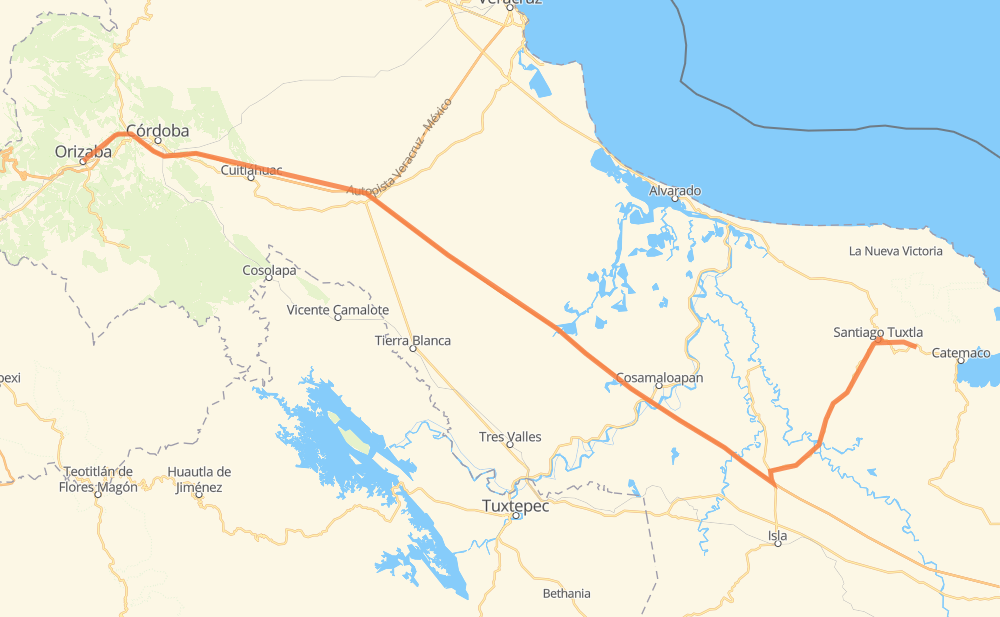
Distance between Orizaba and San Andrés Tuxtla
The distance from Orizaba to San Andrés Tuxtla is 255 kilometers by road including 190 kilometers on motorways. Road takes approximately 2 hours and 49 minutes and goes through Santiago Tuxtla, Ixtaczoquitlán, Sumidero, Buenavista, Peñuela, El Maguey and Sihuapan.
| Shortest distance by air | 204 km ✈️ |
| Car route length | 255 km 🚗 |
| Driving time | 2 h 49 min |
| Fuel amount | 20.4 L |
| Fuel cost | 30.4 GBP |
| Toll roads cost | 376 MXN |
| Point | Distance | Time | Fuel | |
| Orizaba | 0 km | 00 min | 0.0 L | |
|
MEX 150 6 km, 04 min
|
||||
| Ixtaczoquitlán | 6 km | 04 min | 0.4 L | |
|
MEX 150D 2 km, 01 min
|
||||
| Unión y Progreso | 8 km | 05 min | 0.5 L | |
|
MEX 150D 3 km, 01 min
|
||||
| Sumidero | 11 km | 07 min | 0.7 L | |
|
MEX 150D 18 km, 10 min
|
||||
| Peñuela | 29 km | 18 min | 2.1 L | |
|
MEX 150D 17 km, 09 min
|
||||
| El Maguey | 46 km | 27 min | 3.5 L | |
|
MEX 150D 19 km, 10 min
|
||||
| Cerro Alto | 65 km | 38 min | 4.6 L | |
|
MEX 150D 9 km, 04 min
|
||||
| San Antonio | 74 km | 43 min | 5.9 L | |
|
MEX 150D MEX 145D 169 km, 1 h 50 min
|
||||
| Santiago Tuxtla | 243 km | 2 h 33 min | 19.4 L | |
|
MEX 180 17 km, 15 min
|
||||
| San Andrés Tuxtla | 260 km | 2 h 49 min | 19.5 L | |
Frequently Asked Questions
How many toll booths are there from Orizaba to San Andrés Tuxtla?
There are 3 toll booths between Orizaba and San Andrés Tuxtla: Fortín, Cuitláhuac and Cosamaloapan.
How much does the toll booths cost from Orizaba to San Andrés Tuxtla?
Toll roads cost: Fortín (33 MXN) + Cuitláhuac (114 MXN) + Cosamaloapan (229 MXN) = 376 MXN
How much does it cost to drive from Orizaba to San Andrés Tuxtla?
Fuel cost: 30.4 GBP
This fuel cost is calculated as: (Route length 255 km / 100 km) * (Fuel consumption 8 L/100 km) * (Fuel price 1.49 GBP / L)
You can adjust fuel consumption and fuel price here.
Toll roads cost: 376 MXN
How long is a car ride from Orizaba to San Andrés Tuxtla?
Driving time: 2 h 49 min
This time is calculated for driving at the maximum permitted speed, taking into account traffic rules restrictions.
- 61 km with a maximum speed 110 km/h = 33 min
- 112 km with a maximum speed 100 km/h = 1 h 7 min
- 3 km with a maximum speed 96 km/h = 1 min
- 74 km with a maximum speed 80 km/h = 55 min
- 2 km with a maximum speed 70 km/h = 2 min
- 7 km with a maximum speed 50 km/h = 8 min
The calculated driving time does not take into account intermediate stops and traffic jams.
How far is Orizaba to San Andrés Tuxtla by land?
The distance between Orizaba and San Andrés Tuxtla is 255 km by road including 190 km on motorways.
Precise satellite coordinates of highways were used for this calculation. The start and finish points are the centers of Orizaba and San Andrés Tuxtla respectively.
How far is Orizaba to San Andrés Tuxtla by plane?
The shortest distance (air line, as the crow flies) between Orizaba and San Andrés Tuxtla is 204 km.
This distance is calculated using the Haversine formula as a great-circle distance between two points on the surface of a sphere. The start and finish points are the centers of Orizaba and San Andrés Tuxtla respectively. Actual distance between airports may be different.
How many hours is Orizaba from San Andrés Tuxtla by plane?
Boeing 737 airliner needs 15 min to cover the distance of 204 km at a cruising speed of 800 km/h.
Small plane "Cessna 172" needs 55 min to flight this distance at average speed of 220 km/h.
This time is approximate and do not take into account takeoff and landing times, airport location and other real world factors.
How long is a helicopter ride from Orizaba to San Andrés Tuxtla?
Fast helicopter "Eurocopter AS350" or "Hughes OH-6 Cayuse" need 51 min to cover the distance of 204 km at a cruising speed of 240 km/h.
Popular "Robinson R44" needs 58 min to flight this distance at average speed of 210 km/h.
This time is approximate and do not take into account takeoff and landing times, aerodrome location and other real world factors.
What city is halfway between Orizaba and San Andrés Tuxtla?
The halfway point between Orizaba and San Andrés Tuxtla is El Barrio. It is located about 7 km from the exact midpoint by road.
The distance from El Barrio to Orizaba is 120 km and driving will take about 1 h 11 min. The road between El Barrio and San Andrés Tuxtla has length 135 km and will take approximately 1 h 37 min.
The other cities located close to halfway point:
Where is Orizaba in relation to San Andrés Tuxtla?
Orizaba is located 204 km west of San Andrés Tuxtla.
Orizaba has geographic coordinates: latitude 18.84972, longitude -97.10361.
San Andrés Tuxtla has geographic coordinates: latitude 18.4494, longitude -95.21225.
Which highway goes from Orizaba to San Andrés Tuxtla?
The route from Orizaba to San Andrés Tuxtla follows MEX 145D.
Other minor sections pass along the road:
- MEX 150D: 70 km
- MEX 179: 49 km
- MEX 180: 10 km
- MEX 150: 4 km