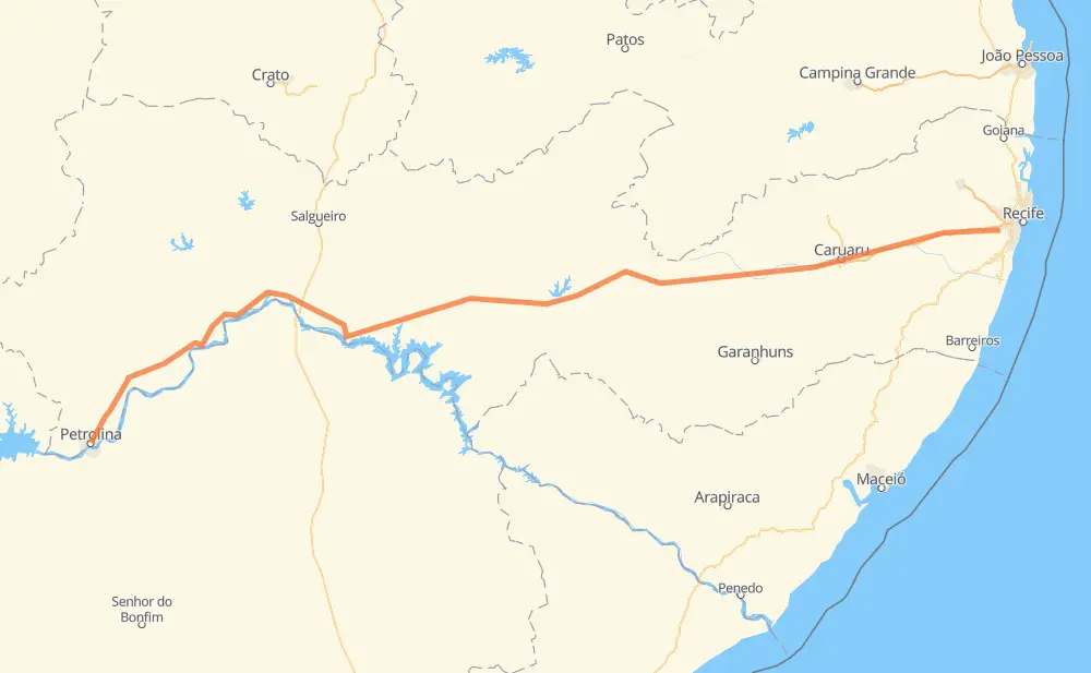
Distance between Petrolina and Jaboatão
The distance from Petrolina to Jaboatão is 695 kilometers by road including 86 kilometers on motorways. Road takes approximately 7 hours and 21 minutes and goes through Cambonge, Vila Três Lagoas Residence, Curado, Campos, Lagoa da Arreia, Moderna and Caraibas.
| Shortest distance by air | 619 km ✈️ |
| Car route length | 695 km 🚗 |
| Driving time | 7 h 21 min |
| Fuel amount | 55.6 L |
| Fuel cost | 82.3 GBP |
| Point | Distance | Time | Fuel | |
| Petrolina | 0 km | 00 min | 0.0 L | |
|
BR-428 390 km, 4 h 09 min
|
||||
| Campos | 390 km | 4 h 09 min | 30.1 L | |
|
BR-110 26 km, 19 min
|
||||
| Moderna | 417 km | 4 h 29 min | 32.3 L | |
|
BR-110 BR-232 47 km, 31 min
|
||||
| Caraibas | 464 km | 5 h 01 min | 36.9 L | |
|
BR-232 7 km, 05 min
|
||||
| Riacho do Meio | 472 km | 5 h 06 min | 37.4 L | |
|
BR-232 96 km, 59 min
|
||||
| Santa Ana | 568 km | 6 h 06 min | 45.0 L | |
|
BR-232 31 km, 17 min
|
||||
| Encruzilhada de São João | 599 km | 6 h 24 min | 47.4 L | |
|
BR-232 86 km, 50 min
|
||||
| Cambonge | 685 km | 7 h 14 min | 54.4 L | |
|
BR-232 7 km, 04 min
|
||||
| Curado | 692 km | 7 h 19 min | 55.4 L | |
|
BR-232 PE-007 3 km, 01 min
|
||||
| -8.11298, -35.01715 | 696 km | 7 h 21 min | 55.6 L | |
Frequently Asked Questions
How much does it cost to drive from Petrolina to Jaboatão?
Fuel cost: 82.3 GBP
This fuel cost is calculated as: (Route length 695 km / 100 km) * (Fuel consumption 8 L/100 km) * (Fuel price 1.48 GBP / L)
You can adjust fuel consumption and fuel price here.
How long is a car ride from Petrolina to Jaboatão?
Driving time: 7 h 21 min
This time is calculated for driving at the maximum permitted speed, taking into account traffic rules restrictions.
- 74 km with a maximum speed 110 km/h = 40 min
- 12 km with a maximum speed 100 km/h = 7 min
- 511 km with a maximum speed 96 km/h = 5 h 19 min
- 96 km with a maximum speed 80 km/h = 1 h 12 min
- 2 km with a maximum speed 60 km/h = 1 min
The calculated driving time does not take into account intermediate stops and traffic jams.
How far is Petrolina to Jaboatão by land?
The distance between Petrolina and Jaboatão is 695 km by road including 86 km on motorways.
Precise satellite coordinates of highways were used for this calculation. The start and finish points are the centers of Petrolina and Jaboatão respectively.
How far is Petrolina to Jaboatão by plane?
The shortest distance (air line, as the crow flies) between Petrolina and Jaboatão is 619 km.
This distance is calculated using the Haversine formula as a great-circle distance between two points on the surface of a sphere. The start and finish points are the centers of Petrolina and Jaboatão respectively. Actual distance between airports may be different.
How many hours is Petrolina from Jaboatão by plane?
Boeing 737 airliner needs 46 min to cover the distance of 619 km at a cruising speed of 800 km/h.
Small plane "Cessna 172" needs 2 h 48 min to flight this distance at average speed of 220 km/h.
This time is approximate and do not take into account takeoff and landing times, airport location and other real world factors.
How long is a helicopter ride from Petrolina to Jaboatão?
Fast helicopter "Eurocopter AS350" or "Hughes OH-6 Cayuse" need 2 h 34 min to cover the distance of 619 km at a cruising speed of 240 km/h.
Popular "Robinson R44" needs 2 h 56 min to flight this distance at average speed of 210 km/h.
This time is approximate and do not take into account takeoff and landing times, aerodrome location and other real world factors.
What city is halfway between Petrolina and Jaboatão?
The halfway point between Petrolina and Jaboatão is Campos. It is located about 43 km from the exact midpoint by road.
The distance from Campos to Petrolina is 390 km and driving will take about 4 h 9 min. The road between Campos and Jaboatão has length 305 km and will take approximately 3 h 11 min.
The other cities located close to halfway point:
Where is Petrolina in relation to Jaboatão?
Petrolina is located 619 km west of Jaboatão.
Petrolina has geographic coordinates: latitude -9.38173, longitude -40.49689.
Jaboatão has geographic coordinates: latitude -8.11298, longitude -35.01715.
Which highway goes from Petrolina to Jaboatão?
The route from Petrolina to Jaboatão follows BR-232, BR-428, PE-360.
Other minor sections pass along the road:
- BR-316: 85 km
- BR-110: 53 km
- BR-122: 49 km
- BR-128: 2 km