Distance between PhinDeli Town Buford WY and Weimar CA
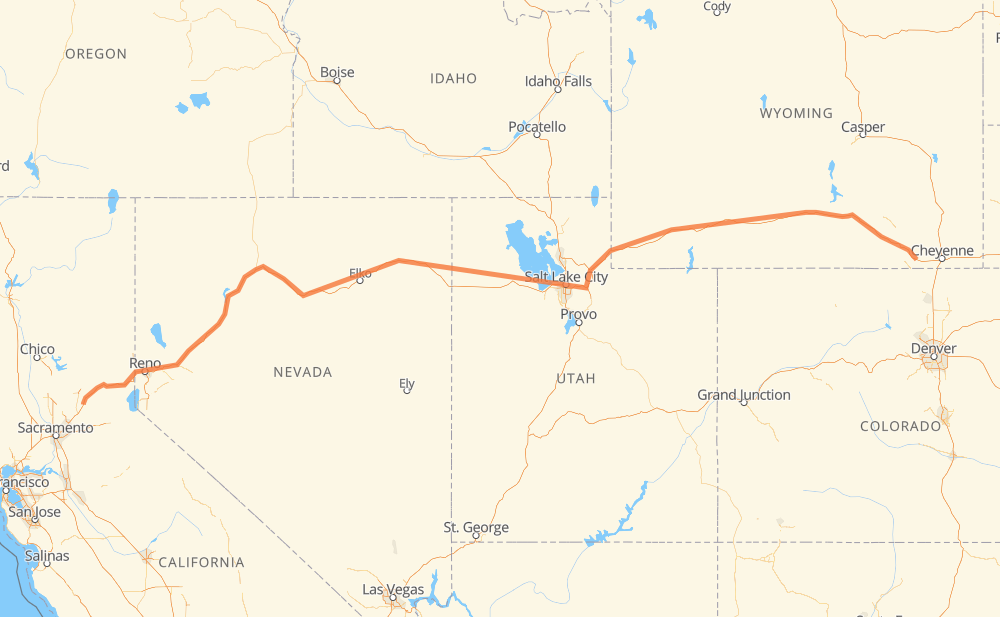
The distance from PhinDeli Town Buford to Weimar is 1,634 kilometers by road including 1,632 kilometers on motorways. Road takes approximately 14 hours and 44 minutes and goes through Laramie, Rock Springs, Salt Lake City and Reno.
| Shortest distance by air | 1,352 km ✈️ |
| Car route length | 1,634 km 🚗 |
| Driving time | 14 h 44 min |
| Fuel amount | 130.7 L |
| Fuel cost | 194.7 GBP |
| Point | Distance | Time | Fuel | |
| PhinDeli Town Buford | 0 km | 00 min | 0.0 L | |
|
I 80 36 km, 20 min
|
||||
| Laramie | 36 km | 20 min | 2.4 L | |
|
I 80 155 km, 1 h 23 min
|
||||
| Rawlins | 192 km | 1 h 43 min | 14.9 L | |
|
I 80 180 km, 1 h 36 min
|
||||
| Rock Springs | 372 km | 3 h 20 min | 29.2 L | |
|
I 80 18 km, 09 min
|
||||
| Green River | 390 km | 3 h 30 min | 30.6 L | |
|
I 80 142 km, 1 h 16 min
|
||||
| Evanston | 532 km | 4 h 46 min | 42.1 L | |
|
I 80 63 km, 33 min
|
||||
| Coalville | 595 km | 5 h 19 min | 47.4 L | |
|
I 80 75 km, 40 min
|
||||
| Salt Lake City | 670 km | 6 h 00 min | 51.9 L | |
|
I 80 824 km, 7 h 22 min
|
||||
| Reno | 1,493 km | 13 h 22 min | 119.4 L | |
|
I 80 140 km, 1 h 21 min
|
||||
| Weimar | 1,634 km | 14 h 43 min | 130.6 L | |
Frequently Asked Questions
How much does it cost to drive from PhinDeli Town Buford to Weimar?
Fuel cost: 194.7 GBP
This fuel cost is calculated as: (Route length 1,634 km / 100 km) * (Fuel consumption 8 L/100 km) * (Fuel price 1.49 GBP / L)
You can adjust fuel consumption and fuel price here.
How long is a car ride from PhinDeli Town Buford to Weimar?
Driving time: 14 h 44 min
This time is calculated for driving at the maximum permitted speed, taking into account traffic rules restrictions.
- 1,457 km with a maximum speed 112 km/h = 13 h
- 172 km with a maximum speed 105 km/h = 1 h 38 min
- 3 km with a maximum speed 80 km/h = 2 min
The calculated driving time does not take into account intermediate stops and traffic jams.
How far is PhinDeli Town Buford to Weimar by land?
The distance between PhinDeli Town Buford and Weimar is 1,634 km by road including 1,632 km on motorways.
Precise satellite coordinates of highways were used for this calculation. The start and finish points are the centers of PhinDeli Town Buford and Weimar respectively.
How far is PhinDeli Town Buford to Weimar by plane?
The shortest distance (air line, as the crow flies) between PhinDeli Town Buford and Weimar is 1,352 km.
This distance is calculated using the Haversine formula as a great-circle distance between two points on the surface of a sphere. The start and finish points are the centers of PhinDeli Town Buford and Weimar respectively. Actual distance between airports may be different.
How many hours is PhinDeli Town Buford from Weimar by plane?
Boeing 737 airliner needs 1 h 41 min to cover the distance of 1,352 km at a cruising speed of 800 km/h.
Small plane "Cessna 172" needs 6 h 8 min to flight this distance at average speed of 220 km/h.
This time is approximate and do not take into account takeoff and landing times, airport location and other real world factors.
How long is a helicopter ride from PhinDeli Town Buford to Weimar?
Fast helicopter "Eurocopter AS350" or "Hughes OH-6 Cayuse" need 5 h 38 min to cover the distance of 1,352 km at a cruising speed of 240 km/h.
Popular "Robinson R44" needs 6 h 26 min to flight this distance at average speed of 210 km/h.
This time is approximate and do not take into account takeoff and landing times, aerodrome location and other real world factors.
What city is halfway between PhinDeli Town Buford and Weimar?
The halfway point between PhinDeli Town Buford and Weimar is Wendover. It is located about 36 km from the exact midpoint by road.
The distance from Wendover to PhinDeli Town Buford is 853 km and driving will take about 7 h 38 min. The road between Wendover and Weimar has length 781 km and will take approximately 7 h 5 min.
The other cities located close to halfway point:
Where is PhinDeli Town Buford in relation to Weimar?
PhinDeli Town Buford is located 1,352 km east of Weimar.
PhinDeli Town Buford has geographic coordinates: latitude 41.12337, longitude -105.30214.
Weimar has geographic coordinates: latitude 39.0374, longitude -120.97244.
Which highway goes from PhinDeli Town Buford to Weimar?
The route from PhinDeli Town Buford to Weimar follows I 80, US 30, US 95, US 189.
Other minor sections pass along the road:
- US 93 ALT: 92 km
- US 95 ALT: 55 km
- WY 789: 38 km
- US 287: 30 km
- US 191: 8 km
- I 15: 4 km
- CA 89: 2 km