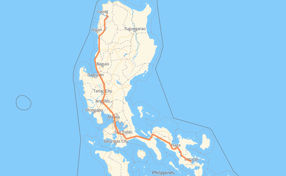
The distance from Piddig to Legazpi is 982 kilometers by road including 256 kilometers on motorways. Road takes approximately 12 hours and 19 minutes and goes through Candon, San Fernando, San Pedro, Biñan, Santa Rosa, Cabuyao and Calamba.
How much does it cost to drive from Piddig to Legazpi?
Fuel cost:
117.1 GBP
This fuel cost is calculated as: (Route length 982 km / 100 km) * (Fuel consumption 8 L/100 km) * (Fuel price 1.49 GBP / L)
You can adjust fuel consumption and fuel price here.
How long is a car ride from Piddig to Legazpi?
Driving time:
12 h 19 min
This time is calculated for driving at the maximum permitted speed, taking into account traffic rules restrictions.
248 km with a maximum speed 100 km/h = 2 h 28 min
64 km with a maximum speed 96 km/h = 39 min
545 km with a maximum speed 80 km/h = 6 h 48 min
15 km with a maximum speed 70 km/h = 12 min
68 km with a maximum speed 60 km/h = 1 h 8 min
21 km with a maximum speed 50 km/h = 25 min
19 km with a maximum speed 40 km/h = 28 min
2 km with a maximum speed 30 km/h = 4 min
1 km with a maximum speed 20 km/h = 2 min
The calculated driving time does not take into account intermediate stops and traffic jams.
How far is Piddig to Legazpi by land?
The distance between Piddig and Legazpi is 982 km by road including 256 km on motorways.
Precise satellite coordinates of highways were used for this calculation. The start and finish points are the centers of Piddig and Legazpi respectively.
How far is Piddig to Legazpi by plane?
The shortest distance (air line, as the crow flies) between Piddig and Legazpi is 646 km.
This distance is calculated using the Haversine formula as a great-circle distance between two points on the surface of a sphere. The start and finish points are the centers of Piddig and Legazpi respectively. Actual distance between airports may be different.
How many hours is Piddig from Legazpi by plane?
Boeing 737 airliner needs 48 min to cover the distance of 646 km at a cruising speed of 800 km/h.
Small plane "Cessna 172" needs 2 h 56 min to flight this distance at average speed of 220 km/h.
This time is approximate and do not take into account takeoff and landing times, airport location and other real world factors.
How long is a helicopter ride from Piddig to Legazpi?
Fast helicopter "Eurocopter AS350" or "Hughes OH-6 Cayuse" need 2 h 41 min to cover the distance of 646 km at a cruising speed of 240 km/h.
Popular "Robinson R44" needs 3 h 4 min to flight this distance at average speed of 210 km/h.
This time is approximate and do not take into account takeoff and landing times, aerodrome location and other real world factors.
What city is halfway between Piddig and Legazpi?
The halfway point between Piddig and Legazpi is Patubig. It is located about 7 km from the exact midpoint by road.
The distance from Patubig to Piddig is 484 km and driving will take about 5 h 52 min. The road between Patubig and Legazpi has length 498 km and will take approximately 6 h 26 min.
The other cities located close to halfway point:
Santa Rita is in 468 km from Piddig and 515 km from Legazpi
Sipat is in 464 km from Piddig and 519 km from Legazpi
Dulong Malabon is in 461 km from Piddig and 521 km from Legazpi
Where is Piddig in relation to Legazpi?
Piddig is located 646 km north-west of Legazpi.
Piddig has geographic coordinates: latitude 18.16359, longitude 120.71653.
Legazpi has geographic coordinates: latitude 13.13886, longitude 123.73431.
Which highway goes from Piddig to Legazpi?
The route from Piddig to Legazpi follows AH26, 1, E1, 2.