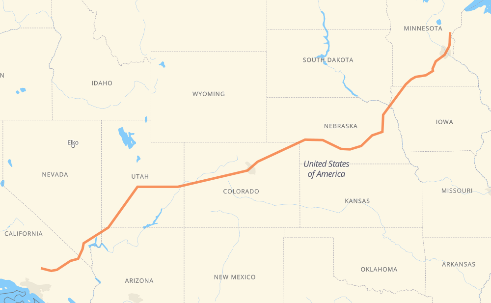
The distance from Pine City to Desert Lake is 3,010 kilometers by road including 2,385 kilometers on motorways. Road takes approximately 28 hours and 50 minutes and goes through Minneapolis, Sioux City, Columbus, Grand Island, North Platte, Denver and Vail.
How much does it cost to drive from Pine City to Desert Lake?
Fuel cost:
358.8 GBP
This fuel cost is calculated as: (Route length 3,010 km / 100 km) * (Fuel consumption 8 L/100 km) * (Fuel price 1.49 GBP / L)
You can adjust fuel consumption and fuel price here.
How long is a car ride from Pine City to Desert Lake?
Driving time:
28 h 50 min
This time is calculated for driving at the maximum permitted speed, taking into account traffic rules restrictions.
1,770 km with a maximum speed 112 km/h = 15 h 48 min
302 km with a maximum speed 105 km/h = 2 h 53 min
113 km with a maximum speed 100 km/h = 1 h 8 min
37 km with a maximum speed 97 km/h = 23 min
565 km with a maximum speed 96 km/h = 5 h 53 min
88 km with a maximum speed 89 km/h = 59 min
19 km with a maximum speed 80 km/h = 14 min
95 km with a maximum speed 80 km/h = 1 h 10 min
12 km with a maximum speed 72 km/h = 10 min
2 km with a maximum speed 64 km/h = 2 min
2 km with a maximum speed 56 km/h = 2 min
3 km with a maximum speed 48 km/h = 4 min
The calculated driving time does not take into account intermediate stops and traffic jams.
How far is Pine City to Desert Lake by land?
The distance between Pine City and Desert Lake is 3,010 km by road including 2,385 km on motorways.
Precise satellite coordinates of highways were used for this calculation. The start and finish points are the centers of Pine City and Desert Lake respectively.
How far is Pine City to Desert Lake by plane?
The shortest distance (air line, as the crow flies) between Pine City and Desert Lake is 2,401 km.
This distance is calculated using the Haversine formula as a great-circle distance between two points on the surface of a sphere. The start and finish points are the centers of Pine City and Desert Lake respectively. Actual distance between airports may be different.
How many hours is Pine City from Desert Lake by plane?
Boeing 737 airliner needs 3 h to cover the distance of 2,401 km at a cruising speed of 800 km/h.
Small plane "Cessna 172" needs 10 h 54 min to flight this distance at average speed of 220 km/h.
This time is approximate and do not take into account takeoff and landing times, airport location and other real world factors.
How long is a helicopter ride from Pine City to Desert Lake?
Fast helicopter "Eurocopter AS350" or "Hughes OH-6 Cayuse" need 10 h to cover the distance of 2,401 km at a cruising speed of 240 km/h.
Popular "Robinson R44" needs 11 h 26 min to flight this distance at average speed of 210 km/h.
This time is approximate and do not take into account takeoff and landing times, aerodrome location and other real world factors.
What city is halfway between Pine City and Desert Lake?
The halfway point between Pine City and Desert Lake is Lakewood. It is located about 1 km from the exact midpoint by road.
The distance from Lakewood to Pine City is 1,504 km and driving will take about 14 h 43 min. The road between Lakewood and Desert Lake has length 1,506 km and will take approximately 14 h 7 min.
The other cities located close to halfway point:
Wheat Ridge is in 1,497 km from Pine City and 1,513 km from Desert Lake
Denver is in 1,491 km from Pine City and 1,518 km from Desert Lake
Thornton is in 1,478 km from Pine City and 1,532 km from Desert Lake
Where is Pine City in relation to Desert Lake?
Pine City is located 2,401 km north-east of Desert Lake.
Pine City has geographic coordinates: latitude 45.82607, longitude -92.96854.
Desert Lake has geographic coordinates: latitude 35.00248, longitude -117.69895.
Which highway goes from Pine City to Desert Lake?
The route from Pine City to Desert Lake follows I 70, I 15, US 6, I 80, I 76, US 50, MN 60, US 30, US 169.