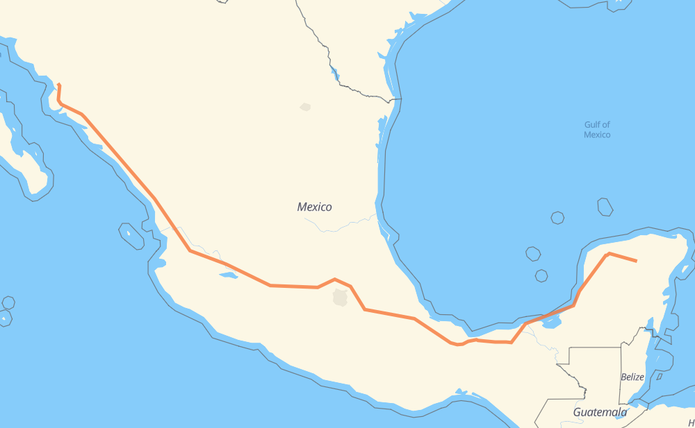
The distance from Pisté to Emiliano Zapata Dos is 2,922 kilometers by road including 2,262 kilometers on motorways. Road takes approximately 31 hours and 56 minutes and goes through Kanasín, Mérida, Orizaba, Tonalá, Tepic, Dimas (Estación Dimas) and Gabriel Leyva Solano.
How much does it cost to drive from Pisté to Emiliano Zapata Dos?
Fuel cost:
346 GBP
This fuel cost is calculated as: (Route length 2,922 km / 100 km) * (Fuel consumption 8 L/100 km) * (Fuel price 1.48 GBP / L)
You can adjust fuel consumption and fuel price here.
Toll roads cost:
3,050 + ? MXN
How long is a car ride from Pisté to Emiliano Zapata Dos?
Driving time:
31 h 56 min
This time is calculated for driving at the maximum permitted speed, taking into account traffic rules restrictions.
66 km with a maximum speed 112 km/h = 35 min
299 km with a maximum speed 110 km/h = 2 h 43 min
1,124 km with a maximum speed 100 km/h = 11 h 14 min
208 km with a maximum speed 96 km/h = 2 h 10 min
102 km with a maximum speed 90 km/h = 1 h 8 min
1,100 km with a maximum speed 80 km/h = 13 h 44 min
16 km with a maximum speed 70 km/h = 13 min
4 km with a maximum speed 60 km/h = 4 min
1 km with a maximum speed 40 km/h = 1 min
The calculated driving time does not take into account intermediate stops and traffic jams.
How far is Pisté to Emiliano Zapata Dos by land?
The distance between Pisté and Emiliano Zapata Dos is 2,922 km by road including 2,262 km on motorways.
Precise satellite coordinates of highways were used for this calculation. The start and finish points are the centers of Pisté and Emiliano Zapata Dos respectively.
How far is Pisté to Emiliano Zapata Dos by plane?
The shortest distance (air line, as the crow flies) between Pisté and Emiliano Zapata Dos is 2,181 km.
This distance is calculated using the Haversine formula as a great-circle distance between two points on the surface of a sphere. The start and finish points are the centers of Pisté and Emiliano Zapata Dos respectively. Actual distance between airports may be different.
How many hours is Pisté from Emiliano Zapata Dos by plane?
Boeing 737 airliner needs 2 h 43 min to cover the distance of 2,181 km at a cruising speed of 800 km/h.
Small plane "Cessna 172" needs 9 h 54 min to flight this distance at average speed of 220 km/h.
This time is approximate and do not take into account takeoff and landing times, airport location and other real world factors.
How long is a helicopter ride from Pisté to Emiliano Zapata Dos?
Fast helicopter "Eurocopter AS350" or "Hughes OH-6 Cayuse" need 9 h 5 min to cover the distance of 2,181 km at a cruising speed of 240 km/h.
Popular "Robinson R44" needs 10 h 23 min to flight this distance at average speed of 210 km/h.
This time is approximate and do not take into account takeoff and landing times, aerodrome location and other real world factors.
What city is halfway between Pisté and Emiliano Zapata Dos?
The halfway point between Pisté and Emiliano Zapata Dos is Tezoquipa. It is located about 13 km from the exact midpoint by road.
The distance from Tezoquipa to Pisté is 1,474 km and driving will take about 16 h 17 min. The road between Tezoquipa and Emiliano Zapata Dos has length 1,448 km and will take approximately 15 h 39 min.
The other cities located close to halfway point:
Xochitlán de las Flores is in 1,497 km from Pisté and 1,425 km from Emiliano Zapata Dos
Jilotepec de Molina Enriquez is in 1,515 km from Pisté and 1,407 km from Emiliano Zapata Dos
José María Morelos (San José) is in 1,390 km from Pisté and 1,532 km from Emiliano Zapata Dos
Where is Pisté in relation to Emiliano Zapata Dos?
Pisté is located 2,181 km south-east of Emiliano Zapata Dos.
Pisté has geographic coordinates: latitude 20.69886, longitude -88.58788.
Emiliano Zapata Dos has geographic coordinates: latitude 26.4716, longitude -109.07066.
Which highway goes from Pisté to Emiliano Zapata Dos?
The route from Pisté to Emiliano Zapata Dos follows MEX 15D, MEX 180, MEX 150D, MEX 145D, MEX M40D, MEX 180D.