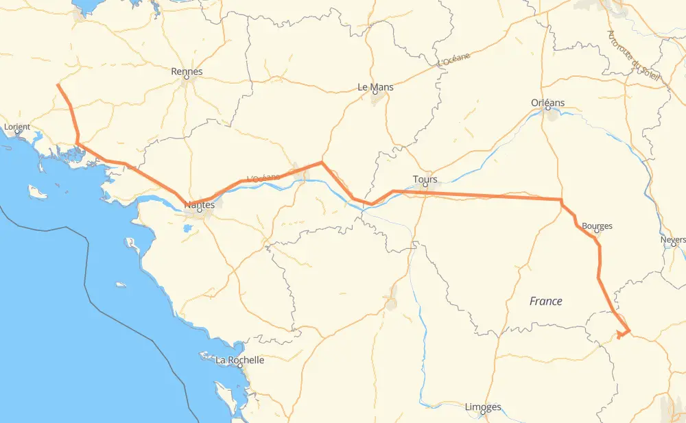
The distance from Pontivy to Montluçon is 606 kilometers by road including 446 kilometers on motorways. Road takes approximately 5 hours and 48 minutes and goes through Nantes, Angers, Saint-Avé, Vannes, Kerniol, Couëron and Saint-Herblain.
How much does it cost to drive from Pontivy to Montluçon?
Fuel cost:
72.2 GBP
This fuel cost is calculated as: (Route length 606 km / 100 km) * (Fuel consumption 8 L/100 km) * (Fuel price 1.49 GBP / L)
You can adjust fuel consumption and fuel price here.
How long is a car ride from Pontivy to Montluçon?
Driving time:
5 h 48 min
This time is calculated for driving at the maximum permitted speed, taking into account traffic rules restrictions.
384 km with a maximum speed 112 km/h = 3 h 25 min
32 km with a maximum speed 110 km/h = 17 min
6 km with a maximum speed 100 km/h = 3 min
121 km with a maximum speed 96 km/h = 1 h 15 min
27 km with a maximum speed 90 km/h = 17 min
30 km with a maximum speed 80 km/h = 22 min
3 km with a maximum speed 70 km/h = 2 min
2 km with a maximum speed 50 km/h = 2 min
The calculated driving time does not take into account intermediate stops and traffic jams.
How far is Pontivy to Montluçon by land?
The distance between Pontivy and Montluçon is 606 km by road including 446 km on motorways.
Precise satellite coordinates of highways were used for this calculation. The start and finish points are the centers of Pontivy and Montluçon respectively.
How far is Pontivy to Montluçon by plane?
The shortest distance (air line, as the crow flies) between Pontivy and Montluçon is 463 km.
This distance is calculated using the Haversine formula as a great-circle distance between two points on the surface of a sphere. The start and finish points are the centers of Pontivy and Montluçon respectively. Actual distance between airports may be different.
How many hours is Pontivy from Montluçon by plane?
Boeing 737 airliner needs 34 min to cover the distance of 463 km at a cruising speed of 800 km/h.
Small plane "Cessna 172" needs 2 h 6 min to flight this distance at average speed of 220 km/h.
This time is approximate and do not take into account takeoff and landing times, airport location and other real world factors.
How long is a helicopter ride from Pontivy to Montluçon?
Fast helicopter "Eurocopter AS350" or "Hughes OH-6 Cayuse" need 1 h 55 min to cover the distance of 463 km at a cruising speed of 240 km/h.
Popular "Robinson R44" needs 2 h 12 min to flight this distance at average speed of 210 km/h.
This time is approximate and do not take into account takeoff and landing times, aerodrome location and other real world factors.
What city is halfway between Pontivy and Montluçon?
The halfway point between Pontivy and Montluçon is Allonnes. It is located about 7 km from the exact midpoint by road.
The distance from Allonnes to Pontivy is 310 km and driving will take about 3 h 5 min. The road between Allonnes and Montluçon has length 296 km and will take approximately 2 h 42 min.
The other cities located close to halfway point:
Les Chauvinières is in 294 km from Pontivy and 311 km from Montluçon
La Grande Varenne is in 325 km from Pontivy and 280 km from Montluçon
La Perrée is in 327 km from Pontivy and 279 km from Montluçon
Where is Pontivy in relation to Montluçon?
Pontivy is located 463 km north-west of Montluçon.
Pontivy has geographic coordinates: latitude 48.06477, longitude -2.96757.
Montluçon has geographic coordinates: latitude 46.33993, longitude 2.60672.
Which highway goes from Pontivy to Montluçon?
The route from Pontivy to Montluçon follows A 85, A 71, N 165, A 11.