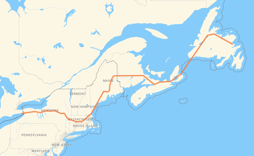
The distance from Port Colborne to Traytown is 2,895 kilometers by road including 1,923 kilometers on motorways. Road takes approximately 35 hours and 40 minutes and goes through Buffalo, Utica, Albany, Worcester, Lowell, Portland and Augusta.
How much does it cost to drive from Port Colborne to Traytown?
Fuel cost:
345.1 GBP
This fuel cost is calculated as: (Route length 2,895 km / 100 km) * (Fuel consumption 8 L/100 km) * (Fuel price 1.49 GBP / L)
You can adjust fuel consumption and fuel price here.
How long is a car ride from Port Colborne to Traytown?
Driving time:
35 h 40 min
This time is calculated for driving at the maximum permitted speed, taking into account traffic rules restrictions.
350 km with a maximum speed 112 km/h = 3 h 7 min
515 km with a maximum speed 110 km/h = 4 h 40 min
787 km with a maximum speed 105 km/h = 7 h 31 min
126 km with a maximum speed 100 km/h = 1 h 15 min
10 km with a maximum speed 97 km/h = 6 min
734 km with a maximum speed 96 km/h = 7 h 38 min
3 km with a maximum speed 90 km/h = 1 min
33 km with a maximum speed 89 km/h = 22 min
9 km with a maximum speed 80 km/h = 6 min
140 km with a maximum speed 80 km/h = 1 h 45 min
2 km with a maximum speed 72 km/h = 1 min
5 km with a maximum speed 70 km/h = 4 min
2 km with a maximum speed 50 km/h = 2 min
2 km with a maximum speed 48 km/h = 1 min
177 km with a maximum speed 20 km/h = 8 h 51 min
The calculated driving time does not take into account intermediate stops and traffic jams.
How far is Port Colborne to Traytown by land?
The distance between Port Colborne and Traytown is 2,895 km by road including 1,923 km on motorways.
Precise satellite coordinates of highways were used for this calculation. The start and finish points are the centers of Port Colborne and Traytown respectively.
How far is Port Colborne to Traytown by plane?
The shortest distance (air line, as the crow flies) between Port Colborne and Traytown is 2,053 km.
This distance is calculated using the Haversine formula as a great-circle distance between two points on the surface of a sphere. The start and finish points are the centers of Port Colborne and Traytown respectively. Actual distance between airports may be different.
How many hours is Port Colborne from Traytown by plane?
Boeing 737 airliner needs 2 h 33 min to cover the distance of 2,053 km at a cruising speed of 800 km/h.
Small plane "Cessna 172" needs 9 h 19 min to flight this distance at average speed of 220 km/h.
This time is approximate and do not take into account takeoff and landing times, airport location and other real world factors.
How long is a helicopter ride from Port Colborne to Traytown?
Fast helicopter "Eurocopter AS350" or "Hughes OH-6 Cayuse" need 8 h 33 min to cover the distance of 2,053 km at a cruising speed of 240 km/h.
Popular "Robinson R44" needs 9 h 46 min to flight this distance at average speed of 210 km/h.
This time is approximate and do not take into account takeoff and landing times, aerodrome location and other real world factors.
What city is halfway between Port Colborne and Traytown?
The halfway point between Port Colborne and Traytown is Fredericton. It is located about 7 km from the exact midpoint by road.
The distance from Fredericton to Port Colborne is 1,441 km and driving will take about 13 h 56 min. The road between Fredericton and Traytown has length 1,454 km and will take approximately 21 h 44 min.
The other cities located close to halfway point:
Jemseg is in 1,492 km from Port Colborne and 1,404 km from Traytown
Meductic is in 1,364 km from Port Colborne and 1,531 km from Traytown
Houlton is in 1,324 km from Port Colborne and 1,571 km from Traytown
Where is Port Colborne in relation to Traytown?
Port Colborne is located 2,053 km west of Traytown.
Port Colborne has geographic coordinates: latitude 42.88603, longitude -79.25331.
Traytown has geographic coordinates: latitude 48.66084, longitude -53.96432.
Which highway goes from Port Colborne to Traytown?
The route from Port Colborne to Traytown follows 1, I 90, I 95, TCH, 2, NS 104, NS 105.