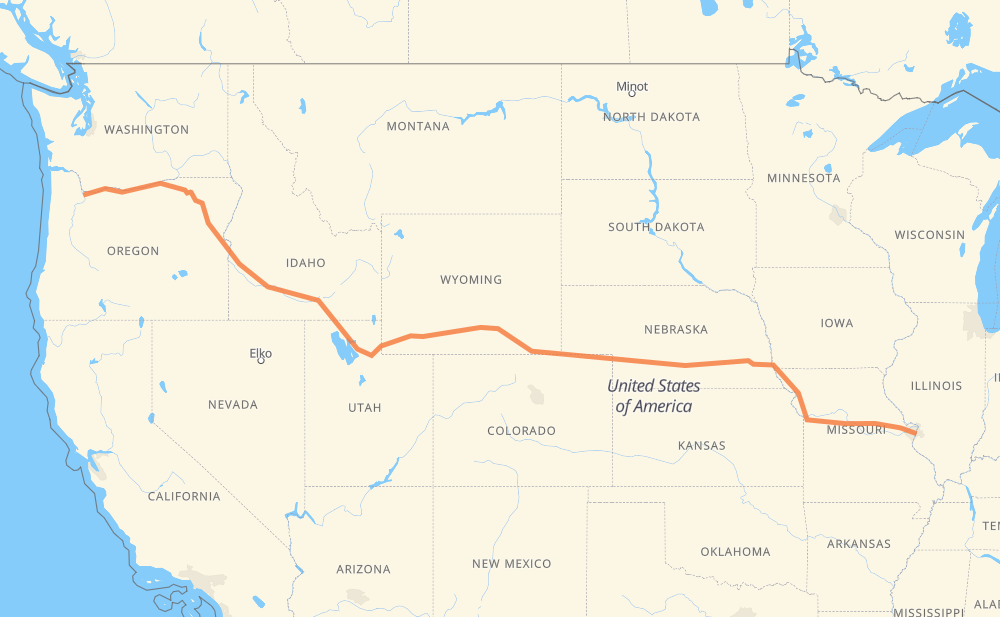
The distance from Portland to St. Louis is 3,285 kilometers by road including 3,194 kilometers on motorways. Road takes approximately 30 hours and 39 minutes and goes through Ogden, Rock Springs, Laramie, Cheyenne, North Platte, Lincoln and Kansas City.
How much does it cost to drive from Portland to St. Louis?
Fuel cost:
391.5 GBP
This fuel cost is calculated as: (Route length 3,285 km / 100 km) * (Fuel consumption 8 L/100 km) * (Fuel price 1.49 GBP / L)
You can adjust fuel consumption and fuel price here.
How long is a car ride from Portland to St. Louis?
Driving time:
30 h 39 min
This time is calculated for driving at the maximum permitted speed, taking into account traffic rules restrictions.
2,471 km with a maximum speed 112 km/h = 22 h 3 min
242 km with a maximum speed 105 km/h = 2 h 18 min
218 km with a maximum speed 100 km/h = 2 h 10 min
77 km with a maximum speed 97 km/h = 47 min
66 km with a maximum speed 96 km/h = 41 min
43 km with a maximum speed 89 km/h = 29 min
152 km with a maximum speed 80 km/h = 1 h 53 min
11 km with a maximum speed 72 km/h = 9 min
1 km with a maximum speed 56 km/h = 1 min
The calculated driving time does not take into account intermediate stops and traffic jams.
How far is Portland to St. Louis by land?
The distance between Portland and St. Louis is 3,285 km by road including 3,194 km on motorways.
Precise satellite coordinates of highways were used for this calculation. The start and finish points are the centers of Portland and St. Louis respectively.
How far is Portland to St. Louis by plane?
The shortest distance (air line, as the crow flies) between Portland and St. Louis is 2,768 km.
This distance is calculated using the Haversine formula as a great-circle distance between two points on the surface of a sphere. The start and finish points are the centers of Portland and St. Louis respectively. Actual distance between airports may be different.
How many hours is Portland from St. Louis by plane?
Boeing 737 airliner needs 3 h 27 min to cover the distance of 2,768 km at a cruising speed of 800 km/h.
Small plane "Cessna 172" needs 12 h 34 min to flight this distance at average speed of 220 km/h.
This time is approximate and do not take into account takeoff and landing times, airport location and other real world factors.
How long is a helicopter ride from Portland to St. Louis?
Fast helicopter "Eurocopter AS350" or "Hughes OH-6 Cayuse" need 11 h 32 min to cover the distance of 2,768 km at a cruising speed of 240 km/h.
Popular "Robinson R44" needs 13 h 10 min to flight this distance at average speed of 210 km/h.
This time is approximate and do not take into account takeoff and landing times, aerodrome location and other real world factors.
What city is halfway between Portland and St. Louis?
The halfway point between Portland and St. Louis is Sinclair.
The distance from Sinclair to Portland is 1,642 km and driving will take about 15 h 34 min. The road between Sinclair and St. Louis has length 1,643 km and will take approximately 15 h 4 min.
The other cities located close to halfway point:
Rawlins is in 1,634 km from Portland and 1,651 km from St. Louis
Creston Junction is in 1,586 km from Portland and 1,699 km from St. Louis
Wamsutter is in 1,571 km from Portland and 1,714 km from St. Louis
Where is Portland in relation to St. Louis?
Portland is located 2,768 km west of St. Louis.
Portland has geographic coordinates: latitude 45.52025, longitude -122.67419.
St. Louis has geographic coordinates: latitude 38.62727, longitude -90.19789.
Which highway goes from Portland to St. Louis?
The route from Portland to St. Louis follows I 80, I 84, US 30, US 40, I 70, I 29, US 26.