Distance between Praga-Nord and Bielsk Podlaski
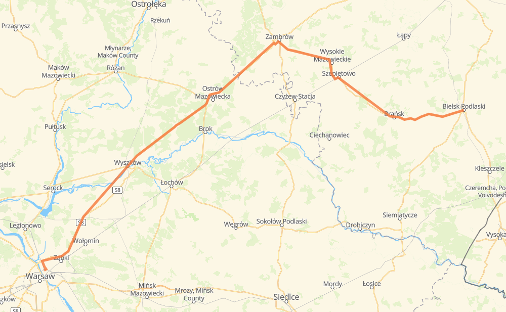
The distance from Praga-Nord to Bielsk Podlaski is 203 kilometers by road. Road takes approximately 2 hours and 24 minutes and goes through Białołęka, Zielonka, Zambrów, Wysokie Mazowieckie, Szepietowo and Brańsk.
| Shortest distance by air | 157 km ✈️ |
| Car route length | 203 km 🚗 |
| Driving time | 2 h 24 min |
| Fuel amount | 16.2 L |
| Fuel cost | 24.2 GBP |
| Point | Distance | Time | Fuel | |
| Praga-Nord | 0 km | 00 min | 0.0 L | |
|
634 S8 6 km, 06 min
|
||||
| Białołęka | 6 km | 06 min | 0.4 L | |
|
S8 7 km, 04 min
|
||||
| Zielonka | 13 km | 11 min | 1.0 L | |
|
S8 8 km, 05 min
|
||||
| Nowy Janków | 22 km | 16 min | 1.6 L | |
|
S8 9 km, 05 min
|
||||
| Emilianów | 31 km | 22 min | 2.3 L | |
|
S8 93 km, 59 min
|
||||
| Zambrów | 124 km | 1 h 21 min | 9.7 L | |
|
63 66 17 km, 13 min
|
||||
| Wysokie Mazowieckie | 141 km | 1 h 35 min | 10.7 L | |
|
66 10 km, 08 min
|
||||
| Szepietowo | 151 km | 1 h 43 min | 11.9 L | |
|
66 26 km, 19 min
|
||||
| Brańsk | 177 km | 2 h 02 min | 14.0 L | |
|
66 26 km, 22 min
|
||||
| Bielsk Podlaski | 203 km | 2 h 24 min | 15.9 L | |
Hotels of Bielsk Podlaski
Frequently Asked Questions
How much does it cost to drive from Praga-Nord to Bielsk Podlaski?
Fuel cost: 24.2 GBP
This fuel cost is calculated as: (Route length 203 km / 100 km) * (Fuel consumption 8 L/100 km) * (Fuel price 1.49 GBP / L)
You can adjust fuel consumption and fuel price here.
How long is a car ride from Praga-Nord to Bielsk Podlaski?
Driving time: 2 h 24 min
This time is calculated for driving at the maximum permitted speed, taking into account traffic rules restrictions.
- 116 km with a maximum speed 96 km/h = 1 h 12 min
- 25 km with a maximum speed 90 km/h = 16 min
- 40 km with a maximum speed 80 km/h = 29 min
- 2 km with a maximum speed 70 km/h = 1 min
- 18 km with a maximum speed 50 km/h = 21 min
The calculated driving time does not take into account intermediate stops and traffic jams.
How far is Praga-Nord to Bielsk Podlaski by land?
The distance between Praga-Nord and Bielsk Podlaski is 203 km by road.
Precise satellite coordinates of highways were used for this calculation. The start and finish points are the centers of Praga-Nord and Bielsk Podlaski respectively.
How far is Praga-Nord to Bielsk Podlaski by plane?
The shortest distance (air line, as the crow flies) between Praga-Nord and Bielsk Podlaski is 157 km.
This distance is calculated using the Haversine formula as a great-circle distance between two points on the surface of a sphere. The start and finish points are the centers of Praga-Nord and Bielsk Podlaski respectively. Actual distance between airports may be different.
How many hours is Praga-Nord from Bielsk Podlaski by plane?
Boeing 737 airliner needs 11 min to cover the distance of 157 km at a cruising speed of 800 km/h.
Small plane "Cessna 172" needs 42 min to flight this distance at average speed of 220 km/h.
This time is approximate and do not take into account takeoff and landing times, airport location and other real world factors.
How long is a helicopter ride from Praga-Nord to Bielsk Podlaski?
Fast helicopter "Eurocopter AS350" or "Hughes OH-6 Cayuse" need 39 min to cover the distance of 157 km at a cruising speed of 240 km/h.
Popular "Robinson R44" needs 44 min to flight this distance at average speed of 210 km/h.
This time is approximate and do not take into account takeoff and landing times, aerodrome location and other real world factors.
What city is halfway between Praga-Nord and Bielsk Podlaski?
The halfway point between Praga-Nord and Bielsk Podlaski is Prosienica. It is located about 2 km from the exact midpoint by road.
The distance from Prosienica to Praga-Nord is 104 km and driving will take about 1 h 7 min. The road between Prosienica and Bielsk Podlaski has length 99 km and will take approximately 1 h 17 min.
The other cities located close to halfway point:
Where is Praga-Nord in relation to Bielsk Podlaski?
Praga-Nord is located 157 km west of Bielsk Podlaski.
Praga-Nord has geographic coordinates: latitude 52.26488, longitude 21.02734.
Bielsk Podlaski has geographic coordinates: latitude 52.76876, longitude 23.19256.
Which highway goes from Praga-Nord to Bielsk Podlaski?
The route from Praga-Nord to Bielsk Podlaski follows S8, 66.
Other minor sections pass along the road:
- 63: 2 km