Distance between Rio Pomba and Flores da Cunha
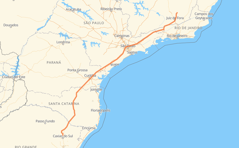
The distance from Rio Pomba to Flores da Cunha is 1,496 kilometers by road including 725 kilometers on motorways. Road takes approximately 17 hours and 4 minutes and goes through Juiz de Fora, Guaratinguetá, Jacareí and Piraquara.
| Shortest distance by air | 1,180 km ✈️ |
| Car route length | 1,496 km 🚗 |
| Driving time | 17 h 4 min |
| Fuel amount | 119.7 L |
| Fuel cost | 178.3 GBP |
| Point | Distance | Time | Fuel | |
| Rio Pomba | 0 km | 00 min | 0.0 L | |
|
MG-133 22 km, 22 min
|
||||
| Tabuleiro | 22 km | 22 min | 0.6 L | |
|
MG-133 MG-353 41 km, 40 min
|
||||
| Muçunge da Grama | 63 km | 1 h 02 min | 4.9 L | |
|
MG-353 10 km, 06 min
|
||||
| Juiz de Fora | 73 km | 1 h 08 min | 5.8 L | |
|
MG-353 2 km, 01 min
|
||||
| São Mateus | 75 km | 1 h 10 min | 5.9 L | |
|
MG-353 34 km, 24 min
|
||||
| Monte Verde | 109 km | 1 h 35 min | 7.8 L | |
|
MG-353 RJ-151 140 km, 1 h 36 min
|
||||
| Floriano | 249 km | 3 h 11 min | 19.4 L | |
|
BR-116 106 km, 1 h 05 min
|
||||
| Guaratinguetá | 355 km | 4 h 16 min | 28.2 L | |
|
SP-060 99 km, 58 min
|
||||
| Jacareí | 454 km | 5 h 15 min | 36.0 L | |
|
SP-060 BR-116 486 km, 5 h 25 min
|
||||
| Piraquara | 940 km | 10 h 40 min | 74.6 L | |
|
BR-116 569 km, 6 h 23 min
|
||||
| -29.03013, -51.18333 | 1,509 km | 17 h 03 min | 120.7 L | |
Hotels of Flores da Cunha
Frequently Asked Questions
How much does it cost to drive from Rio Pomba to Flores da Cunha?
Fuel cost: 178.3 GBP
This fuel cost is calculated as: (Route length 1,496 km / 100 km) * (Fuel consumption 8 L/100 km) * (Fuel price 1.49 GBP / L)
You can adjust fuel consumption and fuel price here.
How long is a car ride from Rio Pomba to Flores da Cunha?
Driving time: 17 h 4 min
This time is calculated for driving at the maximum permitted speed, taking into account traffic rules restrictions.
- 395 km with a maximum speed 110 km/h = 3 h 35 min
- 130 km with a maximum speed 100 km/h = 1 h 18 min
- 448 km with a maximum speed 96 km/h = 4 h 39 min
- 29 km with a maximum speed 90 km/h = 19 min
- 326 km with a maximum speed 80 km/h = 4 h 4 min
- 167 km with a maximum speed 60 km/h = 2 h 46 min
- 4 km with a maximum speed 50 km/h = 4 min
- 10 km with a maximum speed 40 km/h = 14 min
The calculated driving time does not take into account intermediate stops and traffic jams.
How far is Rio Pomba to Flores da Cunha by land?
The distance between Rio Pomba and Flores da Cunha is 1,496 km by road including 725 km on motorways.
Precise satellite coordinates of highways were used for this calculation. The start and finish points are the centers of Rio Pomba and Flores da Cunha respectively.
How far is Rio Pomba to Flores da Cunha by plane?
The shortest distance (air line, as the crow flies) between Rio Pomba and Flores da Cunha is 1,180 km.
This distance is calculated using the Haversine formula as a great-circle distance between two points on the surface of a sphere. The start and finish points are the centers of Rio Pomba and Flores da Cunha respectively. Actual distance between airports may be different.
How many hours is Rio Pomba from Flores da Cunha by plane?
Boeing 737 airliner needs 1 h 28 min to cover the distance of 1,180 km at a cruising speed of 800 km/h.
Small plane "Cessna 172" needs 5 h 21 min to flight this distance at average speed of 220 km/h.
This time is approximate and do not take into account takeoff and landing times, airport location and other real world factors.
How long is a helicopter ride from Rio Pomba to Flores da Cunha?
Fast helicopter "Eurocopter AS350" or "Hughes OH-6 Cayuse" need 4 h 55 min to cover the distance of 1,180 km at a cruising speed of 240 km/h.
Popular "Robinson R44" needs 5 h 37 min to flight this distance at average speed of 210 km/h.
This time is approximate and do not take into account takeoff and landing times, aerodrome location and other real world factors.
What city is halfway between Rio Pomba and Flores da Cunha?
The halfway point between Rio Pomba and Flores da Cunha is Jacupiranga. It is located about 2 km from the exact midpoint by road.
The distance from Jacupiranga to Rio Pomba is 750 km and driving will take about 8 h 16 min. The road between Jacupiranga and Flores da Cunha has length 746 km and will take approximately 8 h 47 min.
The other cities located close to halfway point:
Where is Rio Pomba in relation to Flores da Cunha?
Rio Pomba is located 1,180 km north-east of Flores da Cunha.
Rio Pomba has geographic coordinates: latitude -21.275, longitude -43.17889.
Flores da Cunha has geographic coordinates: latitude -29.03013, longitude -51.18333.
Which highway goes from Rio Pomba to Flores da Cunha?
The route from Rio Pomba to Flores da Cunha follows BR-116, SP-230, SP-060, MG-353.
Other minor sections pass along the road:
- ERS-122: 71 km
- BR-478: 49 km
- MG-133: 43 km
- RJ-151: 36 km
- BR-494: 24 km
- RJ-153: 24 km
- BR-277: 22 km
- RJ-143: 20 km
- SP-015: 16 km
- SP-021: 14 km
- BR-459: 13 km
- BR-383: 11 km
- BR-050: 7 km
- BR-477: 6 km
- SP-280: 5 km
- BR-374: 5 km
- ERS-437: 3 km
- BR-040: 3 km
- SPI-016/021: 2 km
- RJ-159: 1 km