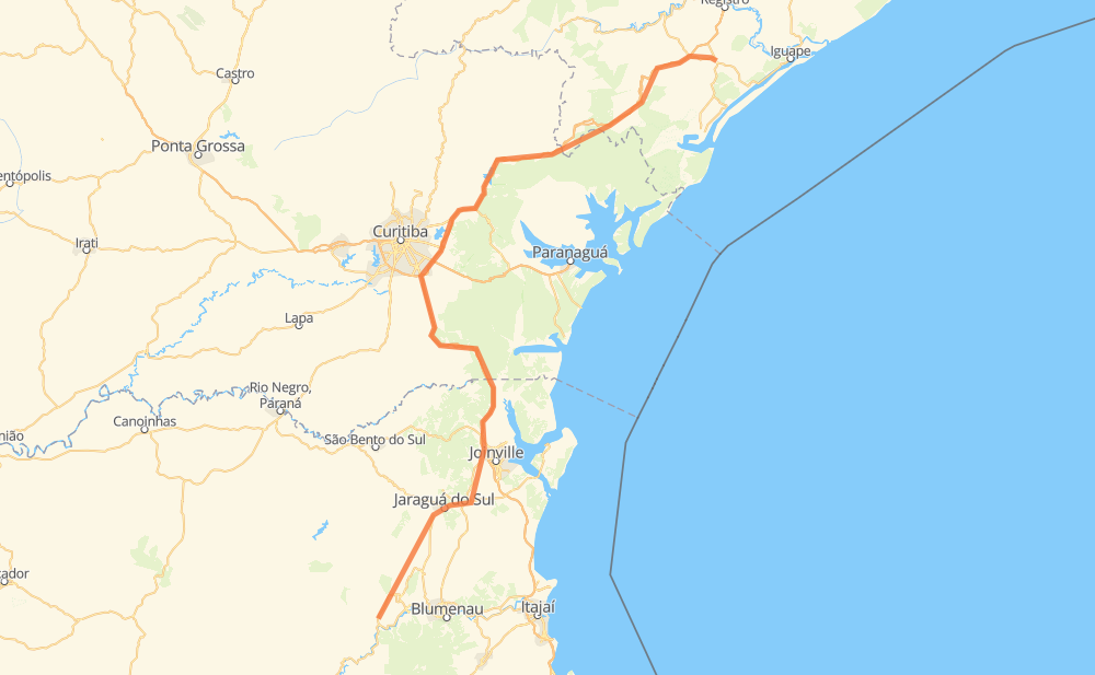
Distance between Rodeio and Pariquera-Açu
The distance from Rodeio to Pariquera-Açu is 416 kilometers by road including 309 kilometers on motorways. Road takes approximately 5 hours and 14 minutes and goes through Piraquara, Timbó, Ribeirão Areia, Rega III, Vila Nova, Zona Industrial Norte and Dona Francisca.
| Shortest distance by air | 287 km ✈️ |
| Car route length | 416 km 🚗 |
| Driving time | 5 h 14 min |
| Fuel amount | 33.3 L |
| Fuel cost | 49.6 GBP |
| Point | Distance | Time | Fuel | |
| Rodeio | 0 km | 00 min | 0.0 L | |
|
SC-110 20 km, 15 min
|
||||
| Timbó | 20 km | 15 min | 1.0 L | |
|
SC-110 15 km, 12 min
|
||||
| Ribeirão Areia | 35 km | 27 min | 2.6 L | |
|
SC-110 9 km, 09 min
|
||||
| Rega III | 44 km | 37 min | 3.2 L | |
|
SC-110 SC-108 61 km, 46 min
|
||||
| Vila Nova | 106 km | 1 h 24 min | 8.3 L | |
|
SC-108 5 km, 03 min
|
||||
| Zona Industrial Norte | 111 km | 1 h 28 min | 8.9 L | |
|
BR-101 6 km, 03 min
|
||||
| Dona Francisca | 117 km | 1 h 32 min | 9.2 L | |
|
BR-101 5 km, 02 min
|
||||
| Pirabeiraba | 121 km | 1 h 35 min | 9.6 L | |
|
BR-101 BR-376 109 km, 1 h 14 min
|
||||
| Piraquara | 230 km | 2 h 49 min | 17.8 L | |
|
BR-116 204 km, 2 h 24 min
|
||||
| Pariquera-Açu | 434 km | 5 h 14 min | 34.6 L | |
Frequently Asked Questions
How much does it cost to drive from Rodeio to Pariquera-Açu?
Fuel cost: 49.6 GBP
This fuel cost is calculated as: (Route length 416 km / 100 km) * (Fuel consumption 8 L/100 km) * (Fuel price 1.49 GBP / L)
You can adjust fuel consumption and fuel price here.
How long is a car ride from Rodeio to Pariquera-Açu?
Driving time: 5 h 14 min
This time is calculated for driving at the maximum permitted speed, taking into account traffic rules restrictions.
- 110 km with a maximum speed 110 km/h = 1 h
- 69 km with a maximum speed 100 km/h = 41 min
- 36 km with a maximum speed 96 km/h = 22 min
- 119 km with a maximum speed 80 km/h = 1 h 29 min
- 13 km with a maximum speed 70 km/h = 10 min
- 80 km with a maximum speed 60 km/h = 1 h 20 min
- 5 km with a maximum speed 50 km/h = 6 min
- 3 km with a maximum speed 40 km/h = 4 min
The calculated driving time does not take into account intermediate stops and traffic jams.
How far is Rodeio to Pariquera-Açu by land?
The distance between Rodeio and Pariquera-Açu is 416 km by road including 309 km on motorways.
Precise satellite coordinates of highways were used for this calculation. The start and finish points are the centers of Rodeio and Pariquera-Açu respectively.
How far is Rodeio to Pariquera-Açu by plane?
The shortest distance (air line, as the crow flies) between Rodeio and Pariquera-Açu is 287 km.
This distance is calculated using the Haversine formula as a great-circle distance between two points on the surface of a sphere. The start and finish points are the centers of Rodeio and Pariquera-Açu respectively. Actual distance between airports may be different.
How many hours is Rodeio from Pariquera-Açu by plane?
Boeing 737 airliner needs 21 min to cover the distance of 287 km at a cruising speed of 800 km/h.
Small plane "Cessna 172" needs 1 h 18 min to flight this distance at average speed of 220 km/h.
This time is approximate and do not take into account takeoff and landing times, airport location and other real world factors.
How long is a helicopter ride from Rodeio to Pariquera-Açu?
Fast helicopter "Eurocopter AS350" or "Hughes OH-6 Cayuse" need 1 h 11 min to cover the distance of 287 km at a cruising speed of 240 km/h.
Popular "Robinson R44" needs 1 h 22 min to flight this distance at average speed of 210 km/h.
This time is approximate and do not take into account takeoff and landing times, aerodrome location and other real world factors.
What city is halfway between Rodeio and Pariquera-Açu?
The halfway point between Rodeio and Pariquera-Açu is Contenda. It is located about 13 km from the exact midpoint by road.
The distance from Contenda to Rodeio is 195 km and driving will take about 2 h 28 min. The road between Contenda and Pariquera-Açu has length 221 km and will take approximately 2 h 46 min.
The other cities located close to halfway point:
Where is Rodeio in relation to Pariquera-Açu?
Rodeio is located 287 km south-west of Pariquera-Açu.
Rodeio has geographic coordinates: latitude -26.92333, longitude -49.36854.
Pariquera-Açu has geographic coordinates: latitude -24.71469, longitude -47.88024.
Which highway goes from Rodeio to Pariquera-Açu?
The route from Rodeio to Pariquera-Açu follows BR-116.
Other minor sections pass along the road:
- SP-230: 86 km
- BR-376: 74 km
- SC-110: 55 km
- BR-101: 33 km
- SC-108: 28 km
- SP-222: 14 km
- BR-280: 10 km
- BR-277: 9 km
- SC-477: 2 km