Distance between São Paulo and Manaus
The distance from São Paulo to Manaus is 5,488 kilometers by road including 121 kilometers on motorways. Road takes approximately 62 hours and 49 minutes and goes through Anápolis, Ariquemes, Porto Velho, Aroreira, Balança, Bonsucesso and Picos.
| Shortest distance by air | 2,348 km ✈️ |
| Car route length | 5,488 km 🚗 |
| Driving time | 62 h 49 min |
| Fuel amount | 439 L |
| Fuel cost | 654.1 GBP |
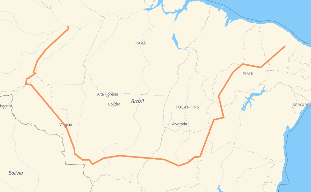
| Point | Distance | Time | Fuel | |
| São Paulo | 0 km | 00 min | 0.0 L | |
|
BR-122 25 km, 20 min
|
||||
| Aroreira | 25 km | 20 min | 1.6 L | |
|
BR-122 13 km, 11 min
|
||||
| Bonsucesso | 38 km | 32 min | 2.4 L | |
|
CE-060 BR-020 409 km, 4 h 31 min
|
||||
| Picos | 447 km | 5 h 03 min | 35.0 L | |
|
BR-230 80 km, 58 min
|
||||
| Rodagem de Floriano | 527 km | 6 h 02 min | 42.0 L | |
|
BR-230 BR-135 927 km, 9 h 45 min
|
||||
| Residencial São Francisco | 1,454 km | 15 h 48 min | 115.9 L | |
|
BR-020 782 km, 8 h 49 min
|
||||
| Anápolis | 2,236 km | 24 h 37 min | 178.8 L | |
|
GO-330 BR-070 2,152 km, 24 h 39 min
|
||||
| Ariquemes | 4,388 km | 49 h 16 min | 349.0 L | |
|
BR-364 217 km, 2 h 29 min
|
||||
| Porto Velho | 4,605 km | 51 h 46 min | 368.2 L | |
|
BR-319 883 km, 11 h 03 min
|
||||
| Manaus | 5,488 km | 62 h 49 min | 438.9 L | |
Hotels of Manaus
Frequently Asked Questions
How much does it cost to drive from São Paulo to Manaus?
Fuel cost: 654.1 GBP
This fuel cost is calculated as: (Route length 5,488 km / 100 km) * (Fuel consumption 8 L/100 km) * (Fuel price 1.49 GBP / L)
You can adjust fuel consumption and fuel price here.
How long is a car ride from São Paulo to Manaus?
Driving time: 62 h 49 min
This time is calculated for driving at the maximum permitted speed, taking into account traffic rules restrictions.
- 72 km with a maximum speed 110 km/h = 39 min
- 3,330 km with a maximum speed 96 km/h = 34 h 41 min
- 1,938 km with a maximum speed 80 km/h = 24 h 13 min
- 30 km with a maximum speed 60 km/h = 29 min
- 96 km with a maximum speed 50 km/h = 1 h 54 min
- 9 km with a maximum speed 40 km/h = 13 min
- 1 km with a maximum speed 30 km/h = 1 min
- 12 km with a maximum speed 20 km/h = 35 min
The calculated driving time does not take into account intermediate stops and traffic jams.
How far is São Paulo to Manaus by land?
The distance between São Paulo and Manaus is 5,488 km by road including 121 km on motorways.
Precise satellite coordinates of highways were used for this calculation. The start and finish points are the centers of São Paulo and Manaus respectively.
How far is São Paulo to Manaus by plane?
The shortest distance (air line, as the crow flies) between São Paulo and Manaus is 2,348 km.
This distance is calculated using the Haversine formula as a great-circle distance between two points on the surface of a sphere. The start and finish points are the centers of São Paulo and Manaus respectively. Actual distance between airports may be different.
How many hours is São Paulo from Manaus by plane?
Boeing 737 airliner needs 2 h 56 min to cover the distance of 2,348 km at a cruising speed of 800 km/h.
Small plane "Cessna 172" needs 10 h 40 min to flight this distance at average speed of 220 km/h.
This time is approximate and do not take into account takeoff and landing times, airport location and other real world factors.
How long is a helicopter ride from São Paulo to Manaus?
Fast helicopter "Eurocopter AS350" or "Hughes OH-6 Cayuse" need 9 h 47 min to cover the distance of 2,348 km at a cruising speed of 240 km/h.
Popular "Robinson R44" needs 11 h 10 min to flight this distance at average speed of 210 km/h.
This time is approximate and do not take into account takeoff and landing times, aerodrome location and other real world factors.
What city is halfway between São Paulo and Manaus?
The halfway point between São Paulo and Manaus is Campo Alegre. It is located about 230 km from the exact midpoint by road.
The distance from Campo Alegre to São Paulo is 2,513 km and driving will take about 27 h 34 min. The road between Campo Alegre and Manaus has length 2,974 km and will take approximately 35 h 15 min.
The other cities located close to halfway point:
Where is São Paulo in relation to Manaus?
São Paulo is located 2,348 km east of Manaus.
São Paulo has geographic coordinates: latitude -5.05873, longitude -38.90898.
Manaus has geographic coordinates: latitude -3.13163, longitude -59.9825.
Which highway goes from São Paulo to Manaus?
The route from São Paulo to Manaus follows BR-070, BR-020, BR-319, BR-364, BR-135, BR-174, BR-230, PI-250, BR-343, GO-070, BR-060.
Other minor sections pass along the road:
- CE-060: 99 km
- BR-242: 88 km
- MT-110: 78 km
- BR-163: 75 km
- BR-226: 67 km
- GO-222: 60 km
- BR-316: 60 km
- BR-010: 25 km
- BR-030: 25 km
- DF-003: 22 km
- MT-407: 16 km
- GO-108: 15 km
- BR-122: 13 km
- DF-075: 11 km
- BR-158: 10 km
- PI-394: 6 km
- MT-130: 4 km
- BR-407: 4 km
- GO-330: 2 km
- PI-140: 1 km
- GO-188: 1 km