Distance between São Paulo and Victoria de la Conquista
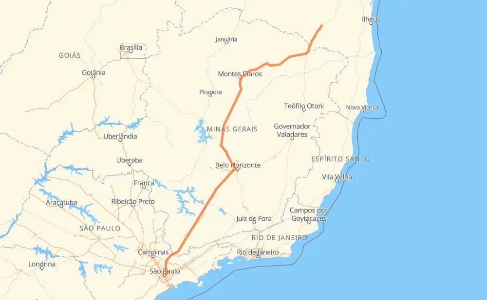
The distance from São Paulo to Victoria de la Conquista is 1,452 kilometers by road including 658 kilometers on motorways. Road takes approximately 15 hours and 50 minutes and goes through Atibaia, Betim, Contagem and Ribeirão das Neves.
| Shortest distance by air | 1,142 km ✈️ |
| Car route length | 1,452 km 🚗 |
| Driving time | 15 h 50 min |
| Fuel amount | 116.2 L |
| Fuel cost | 173.1 GBP |
| Point | Distance | Time | Fuel | |
| São Paulo | 0 km | 00 min | 0.0 L | |
|
BR-050 3 km, 02 min
|
||||
| Vila Sá Barbosa | 3 km | 02 min | 0.2 L | |
|
BR-050 BR-381 13 km, 10 min
|
||||
| Jardim Modelo | 16 km | 13 min | 1.3 L | |
|
SP-010 23 km, 17 min
|
||||
| Rio Acima | 40 km | 31 min | 3.0 L | |
|
SP-010 23 km, 15 min
|
||||
| Atibaia | 62 km | 46 min | 3.9 L | |
|
SP-010 22 km, 13 min
|
||||
| Água Comprida | 84 km | 1 h 00 min | 6.7 L | |
|
SP-010 BR-381 469 km, 4 h 29 min
|
||||
| Betim | 553 km | 5 h 29 min | 43.9 L | |
|
BR-381 16 km, 10 min
|
||||
| Contagem | 569 km | 5 h 40 min | 45.1 L | |
|
BR-040 22 km, 17 min
|
||||
| Ribeirão das Neves | 591 km | 5 h 57 min | 46.9 L | |
|
BR-040 BR-135 861 km, 9 h 53 min
|
||||
| Victoria de la Conquista | 1,453 km | 15 h 50 min | 116.1 L | |
Hotels of Victoria de la Conquista
Frequently Asked Questions
How much does it cost to drive from São Paulo to Victoria de la Conquista?
Fuel cost: 173.1 GBP
This fuel cost is calculated as: (Route length 1,452 km / 100 km) * (Fuel consumption 8 L/100 km) * (Fuel price 1.49 GBP / L)
You can adjust fuel consumption and fuel price here.
How long is a car ride from São Paulo to Victoria de la Conquista?
Driving time: 15 h 50 min
This time is calculated for driving at the maximum permitted speed, taking into account traffic rules restrictions.
- 479 km with a maximum speed 110 km/h = 4 h 21 min
- 26 km with a maximum speed 100 km/h = 15 min
- 348 km with a maximum speed 96 km/h = 3 h 37 min
- 57 km with a maximum speed 90 km/h = 38 min
- 499 km with a maximum speed 80 km/h = 6 h 13 min
- 23 km with a maximum speed 70 km/h = 19 min
- 11 km with a maximum speed 60 km/h = 10 min
- 2 km with a maximum speed 50 km/h = 2 min
- 7 km with a maximum speed 40 km/h = 9 min
The calculated driving time does not take into account intermediate stops and traffic jams.
How far is São Paulo to Victoria de la Conquista by land?
The distance between São Paulo and Victoria de la Conquista is 1,452 km by road including 658 km on motorways.
Precise satellite coordinates of highways were used for this calculation. The start and finish points are the centers of São Paulo and Victoria de la Conquista respectively.
How far is São Paulo to Victoria de la Conquista by plane?
The shortest distance (air line, as the crow flies) between São Paulo and Victoria de la Conquista is 1,142 km.
This distance is calculated using the Haversine formula as a great-circle distance between two points on the surface of a sphere. The start and finish points are the centers of São Paulo and Victoria de la Conquista respectively. Actual distance between airports may be different.
How many hours is São Paulo from Victoria de la Conquista by plane?
Boeing 737 airliner needs 1 h 25 min to cover the distance of 1,142 km at a cruising speed of 800 km/h.
Small plane "Cessna 172" needs 5 h 11 min to flight this distance at average speed of 220 km/h.
This time is approximate and do not take into account takeoff and landing times, airport location and other real world factors.
How long is a helicopter ride from São Paulo to Victoria de la Conquista?
Fast helicopter "Eurocopter AS350" or "Hughes OH-6 Cayuse" need 4 h 45 min to cover the distance of 1,142 km at a cruising speed of 240 km/h.
Popular "Robinson R44" needs 5 h 26 min to flight this distance at average speed of 210 km/h.
This time is approximate and do not take into account takeoff and landing times, aerodrome location and other real world factors.
What city is halfway between São Paulo and Victoria de la Conquista?
The halfway point between São Paulo and Victoria de la Conquista is Curvelo. It is located about 3 km from the exact midpoint by road.
The distance from Curvelo to São Paulo is 729 km and driving will take about 7 h 24 min. The road between Curvelo and Victoria de la Conquista has length 724 km and will take approximately 8 h 26 min.
The other cities located close to halfway point:
Where is São Paulo in relation to Victoria de la Conquista?
São Paulo is located 1,142 km south-west of Victoria de la Conquista.
São Paulo has geographic coordinates: latitude -23.55065, longitude -46.63338.
Victoria de la Conquista has geographic coordinates: latitude -14.85675, longitude -40.84148.
Which highway goes from São Paulo to Victoria de la Conquista?
The route from São Paulo to Victoria de la Conquista follows BR-381, BR-135, BR-251, BR-116, BR-040.
Other minor sections pass along the road:
- SP-010: 89 km
- CMG-135: 46 km
- BR-122: 19 km
- LMG-653: 11 km
- MGC-251: 9 km
- MGC-122: 9 km
- CMG-122: 9 km
- CMG-251: 9 km
- BR-262: 7 km
- SP-060: 3 km
- BR-494: 2 km