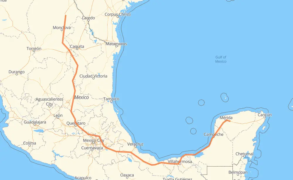
Distance between Sabinas and San Rafael
The distance from Sabinas to San Rafael is 2,456 kilometers by road including 1,550 kilometers on motorways. Road takes approximately 26 hours and 40 minutes and goes through Monclova, San Juan del Rio, Orizaba, Mérida and Kanasín.
| Shortest distance by air | 1,426 km ✈️ |
| Car route length | 2,456 km 🚗 |
| Driving time | 26 h 40 min |
| Fuel amount | 196.5 L |
| Fuel cost | 292.8 GBP |
| Toll roads cost | 1,279 + ? MXN |
| Point | Distance | Time | Fuel | |
| Sabinas | 0 km | 00 min | 0.0 L | |
|
MEX 57 115 km, 1 h 15 min
|
||||
| Monclova | 115 km | 1 h 15 min | 8.8 L | |
|
MEX 57 12 km, 09 min
|
||||
| Castaños | 127 km | 1 h 25 min | 9.9 L | |
|
MEX 57 177 km, 1 h 58 min
|
||||
| Arteaga | 304 km | 3 h 24 min | 24.1 L | |
|
MEX 57D 65 km, 38 min
|
||||
| San Rafael | 369 km | 4 h 02 min | 29.2 L | |
|
MEX 57 602 km, 6 h 20 min
|
||||
| San Juan del Rio | 972 km | 10 h 23 min | 77.2 L | |
|
MEX 57 MEX M40D 415 km, 4 h 29 min
|
||||
| Orizaba | 1,387 km | 14 h 52 min | 110.6 L | |
|
MEX 150D MEX 180 1,034 km, 11 h 18 min
|
||||
| Mérida | 2,420 km | 26 h 11 min | 193.2 L | |
|
22 km, 15 min
|
||||
| Kanasín | 2,442 km | 26 h 27 min | 194.0 L | |
|
MEX 180 17 km, 12 min
|
||||
| San Rafael | 2,460 km | 26 h 40 min | 196.8 L | |
Frequently Asked Questions
How many toll booths are there from Sabinas to San Rafael?
There are 22 toll booths between Sabinas and San Rafael: La Carbonera, Los Chorros, Matehuala Omega, Fortín, Cuitláhuac, Cosamaloapan, Acayucan, Antonio Dovali, Libramiento Oriente De SLP, Chichimequillas, Queretaro, Palmillas, San Martin Texmelucan, San Martín, Viaducto Elevado de Puebla, Amozoc, Esperanza 27, Sánchez Magallanes, Villahermosa Nacajuca, Zacatal, Unidad and Seybaplaya.
How much does the toll booths cost from Sabinas to San Rafael?
Toll roads cost: La Carbonera (42 MXN) + Los Chorros (66 MXN) + Matehuala Omega (?) + Libramiento Oriente De SLP (70 MXN) + Chichimequillas (51 MXN) + Palmillas (89 MXN) + Queretaro (?) + San Martin Texmelucan (?) + San Martín (42 MXN) + Viaducto Elevado de Puebla (?) + Amozoc (72 MXN) + Esperanza 27 (140 MXN) + Fortín (33 MXN) + Cuitláhuac (114 MXN) + Cosamaloapan (229 MXN) + Acayucan (?) + Antonio Dovali (20 MXN) + Sánchez Magallanes (82 MXN) + Villahermosa Nacajuca (62 MXN) + Zacatal (90 MXN) + Unidad (?) + Seybaplaya (77 MXN) = 1,279 + ? MXN
How much does it cost to drive from Sabinas to San Rafael?
Fuel cost: 292.8 GBP
This fuel cost is calculated as: (Route length 2,456 km / 100 km) * (Fuel consumption 8 L/100 km) * (Fuel price 1.49 GBP / L)
You can adjust fuel consumption and fuel price here.
Toll roads cost: 1,279 + ? MXN
How long is a car ride from Sabinas to San Rafael?
Driving time: 26 h 40 min
This time is calculated for driving at the maximum permitted speed, taking into account traffic rules restrictions.
- 228 km with a maximum speed 110 km/h = 2 h 4 min
- 871 km with a maximum speed 100 km/h = 8 h 42 min
- 300 km with a maximum speed 96 km/h = 3 h 7 min
- 412 km with a maximum speed 90 km/h = 4 h 34 min
- 633 km with a maximum speed 80 km/h = 7 h 54 min
- 6 km with a maximum speed 70 km/h = 4 min
- 1 km with a maximum speed 60 km/h = 1 min
- 9 km with a maximum speed 50 km/h = 10 min
The calculated driving time does not take into account intermediate stops and traffic jams.
How far is Sabinas to San Rafael by land?
The distance between Sabinas and San Rafael is 2,456 km by road including 1,550 km on motorways.
Precise satellite coordinates of highways were used for this calculation. The start and finish points are the centers of Sabinas and San Rafael respectively.
How far is Sabinas to San Rafael by plane?
The shortest distance (air line, as the crow flies) between Sabinas and San Rafael is 1,426 km.
This distance is calculated using the Haversine formula as a great-circle distance between two points on the surface of a sphere. The start and finish points are the centers of Sabinas and San Rafael respectively. Actual distance between airports may be different.
How many hours is Sabinas from San Rafael by plane?
Boeing 737 airliner needs 1 h 46 min to cover the distance of 1,426 km at a cruising speed of 800 km/h.
Small plane "Cessna 172" needs 6 h 28 min to flight this distance at average speed of 220 km/h.
This time is approximate and do not take into account takeoff and landing times, airport location and other real world factors.
How long is a helicopter ride from Sabinas to San Rafael?
Fast helicopter "Eurocopter AS350" or "Hughes OH-6 Cayuse" need 5 h 56 min to cover the distance of 1,426 km at a cruising speed of 240 km/h.
Popular "Robinson R44" needs 6 h 47 min to flight this distance at average speed of 210 km/h.
This time is approximate and do not take into account takeoff and landing times, aerodrome location and other real world factors.
What city is halfway between Sabinas and San Rafael?
The halfway point between Sabinas and San Rafael is San Miguel Xoxtla. It is located about 1 km from the exact midpoint by road.
The distance from San Miguel Xoxtla to Sabinas is 1,227 km and driving will take about 13 h 1 min. The road between San Miguel Xoxtla and San Rafael has length 1,229 km and will take approximately 13 h 38 min.
The other cities located close to halfway point:
Where is Sabinas in relation to San Rafael?
Sabinas is located 1,426 km north-west of San Rafael.
Sabinas has geographic coordinates: latitude 27.85319, longitude -101.12679.
San Rafael has geographic coordinates: latitude 20.87581, longitude -89.30485.
Which highway goes from Sabinas to San Rafael?
The route from Sabinas to San Rafael follows MEX 57, MEX 180, MEX 150D, MEX 145D, MEX 57D, MEX M40D, MEX 180D.
Other minor sections pass along the road:
- MEX 80: 82 km
- MEX 45: 40 km
- MEX 120: 12 km