Distance between Salvatierra and JCarlos A. Madrazo
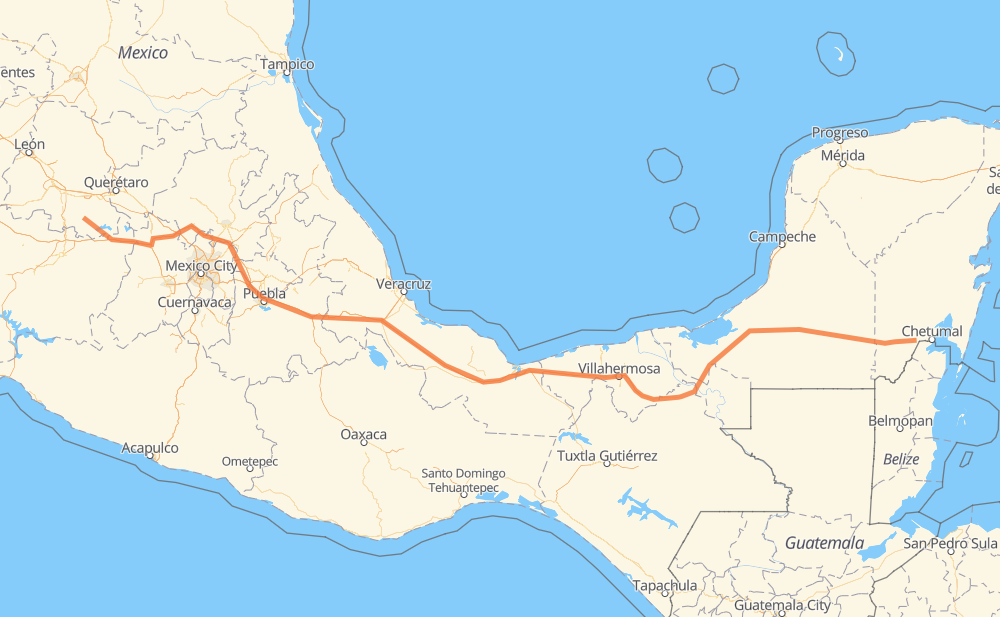
The distance from Salvatierra to JCarlos A. Madrazo is 1,561 kilometers by road including 912 kilometers on motorways. Road takes approximately 17 hours and 24 minutes and goes through Orizaba, Villahermosa, Acámbaro, Maravatio, Pastores, Jilotepec de Molina Enriquez and Santa María Moyotzingo.
| Shortest distance by air | 1,310 km ✈️ |
| Car route length | 1,561 km 🚗 |
| Driving time | 17 h 24 min |
| Fuel amount | 124.9 L |
| Fuel cost | 186 GBP |
| Toll roads cost | 830 + ? MXN |
| Point | Distance | Time | Fuel | |
| Salvatierra | 0 km | 00 min | 0.0 L | |
|
MEX 51 32 km, 24 min
|
||||
| Acámbaro | 32 km | 24 min | 2.2 L | |
|
MEX 51 MEX 61 37 km, 28 min
|
||||
| Maravatio | 69 km | 53 min | 5.4 L | |
|
MEX 15D 112 km, 1 h 13 min
|
||||
| Jilotepec de Molina Enriquez | 180 km | 2 h 06 min | 14.0 L | |
|
MEX M40D 180 km, 1 h 53 min
|
||||
| Santa María Moyotzingo | 360 km | 4 h 00 min | 28.6 L | |
|
MEX 150D 12 km, 07 min
|
||||
| San Miguel Xoxtla | 372 km | 4 h 08 min | 29.2 L | |
|
MEX 150D 8 km, 05 min
|
||||
| San Francisco Ocotlán (Ocotlán) | 380 km | 4 h 13 min | 30.3 L | |
|
MEX 150D 152 km, 1 h 45 min
|
||||
| Orizaba | 532 km | 5 h 58 min | 42.2 L | |
|
MEX 150D MEX 145D 488 km, 5 h 04 min
|
||||
| Villahermosa | 1,019 km | 11 h 02 min | 81.1 L | |
|
MEX 186 545 km, 6 h 21 min
|
||||
| JCarlos A. Madrazo | 1,564 km | 17 h 24 min | 121.7 L | |
Frequently Asked Questions
How many toll booths are there from Salvatierra to JCarlos A. Madrazo?
There are 16 toll booths between Salvatierra and JCarlos A. Madrazo: Fortín, Cuitláhuac, Cosamaloapan, Acayucan, Antonio Dovali, Contepec, Atlacomulco — Maravatio, Atlacomulco 2, San Martin Texmelucan, San Martín, Viaducto Elevado de Puebla, Amozoc, Esperanza 27, Usumacinta, Sánchez Magallanes and Grijalva.
How much does the toll booths cost from Salvatierra to JCarlos A. Madrazo?
Toll roads cost: Contepec (?) + Atlacomulco — Maravatio (50 MXN) + Atlacomulco 2 (?) + San Martin Texmelucan (?) + San Martín (42 MXN) + Viaducto Elevado de Puebla (?) + Amozoc (72 MXN) + Esperanza 27 (140 MXN) + Fortín (33 MXN) + Cuitláhuac (114 MXN) + Cosamaloapan (229 MXN) + Acayucan (?) + Antonio Dovali (20 MXN) + Sánchez Magallanes (82 MXN) + Grijalva (24 MXN) + Usumacinta (24 MXN) = 830 + ? MXN
How much does it cost to drive from Salvatierra to JCarlos A. Madrazo?
Fuel cost: 186 GBP
This fuel cost is calculated as: (Route length 1,561 km / 100 km) * (Fuel consumption 8 L/100 km) * (Fuel price 1.49 GBP / L)
You can adjust fuel consumption and fuel price here.
Toll roads cost: 830 + ? MXN
How long is a car ride from Salvatierra to JCarlos A. Madrazo?
Driving time: 17 h 24 min
This time is calculated for driving at the maximum permitted speed, taking into account traffic rules restrictions.
- 126 km with a maximum speed 110 km/h = 1 h 8 min
- 528 km with a maximum speed 100 km/h = 5 h 17 min
- 130 km with a maximum speed 96 km/h = 1 h 21 min
- 172 km with a maximum speed 90 km/h = 1 h 54 min
- 588 km with a maximum speed 80 km/h = 7 h 20 min
- 5 km with a maximum speed 70 km/h = 4 min
- 5 km with a maximum speed 60 km/h = 5 min
- 6 km with a maximum speed 50 km/h = 7 min
- 3 km with a maximum speed 40 km/h = 5 min
The calculated driving time does not take into account intermediate stops and traffic jams.
How far is Salvatierra to JCarlos A. Madrazo by land?
The distance between Salvatierra and JCarlos A. Madrazo is 1,561 km by road including 912 km on motorways.
Precise satellite coordinates of highways were used for this calculation. The start and finish points are the centers of Salvatierra and JCarlos A. Madrazo respectively.
How far is Salvatierra to JCarlos A. Madrazo by plane?
The shortest distance (air line, as the crow flies) between Salvatierra and JCarlos A. Madrazo is 1,310 km.
This distance is calculated using the Haversine formula as a great-circle distance between two points on the surface of a sphere. The start and finish points are the centers of Salvatierra and JCarlos A. Madrazo respectively. Actual distance between airports may be different.
How many hours is Salvatierra from JCarlos A. Madrazo by plane?
Boeing 737 airliner needs 1 h 38 min to cover the distance of 1,310 km at a cruising speed of 800 km/h.
Small plane "Cessna 172" needs 5 h 57 min to flight this distance at average speed of 220 km/h.
This time is approximate and do not take into account takeoff and landing times, airport location and other real world factors.
How long is a helicopter ride from Salvatierra to JCarlos A. Madrazo?
Fast helicopter "Eurocopter AS350" or "Hughes OH-6 Cayuse" need 5 h 27 min to cover the distance of 1,310 km at a cruising speed of 240 km/h.
Popular "Robinson R44" needs 6 h 14 min to flight this distance at average speed of 210 km/h.
This time is approximate and do not take into account takeoff and landing times, aerodrome location and other real world factors.
What city is halfway between Salvatierra and JCarlos A. Madrazo?
The halfway point between Salvatierra and JCarlos A. Madrazo is San Pedro Mártir. It is located about 48 km from the exact midpoint by road.
The distance from San Pedro Mártir to Salvatierra is 829 km and driving will take about 8 h 56 min. The road between San Pedro Mártir and JCarlos A. Madrazo has length 732 km and will take approximately 8 h 28 min.
The other cities located close to halfway point:
Where is Salvatierra in relation to JCarlos A. Madrazo?
Salvatierra is located 1,310 km west of JCarlos A. Madrazo.
Salvatierra has geographic coordinates: latitude 20.21613, longitude -100.88207.
JCarlos A. Madrazo has geographic coordinates: latitude 18.49953, longitude -88.52941.
Which highway goes from Salvatierra to JCarlos A. Madrazo?
The route from Salvatierra to JCarlos A. Madrazo follows MEX 186, MEX 150D, MEX 145D, MEX M40D.
Other minor sections pass along the road:
- MEX 180: 98 km
- MEX 180D: 87 km
- MEX 15D: 64 km
- MEX 61: 34 km
- MEX 51: 28 km
- MEX 040D: 7 km
- 186: 1 km