Distance between San Martín Texmelucan de Labastida and Sanctorum
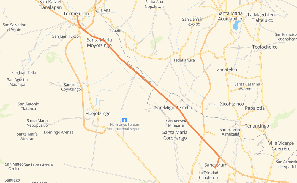
The distance from San Martín Texmelucan de Labastida to Sanctorum is 31 kilometers by road including 26 kilometers on motorways. Road takes approximately 22 minutes and goes through Santa María Moyotzingo, San Miguel Xoxtla, San Francisco Ocotlán (Ocotlán) and Santo Domingo Cienega Honda.
| Shortest distance by air | 28 km ✈️ |
| Car route length | 31 km 🚗 |
| Driving time | 22 min |
| Fuel amount | 2.4 L |
| Fuel cost | 3.6 GBP |
| Toll roads cost | 42 + ? MXN |
| Point | Distance | Time | Fuel | |
| San Martín Texmelucan de Labastida | 0 km | 00 min | 0.0 L | |
|
MEX 190 MEX 150D 6 km, 04 min
|
||||
| Santa María Moyotzingo | 6 km | 04 min | 0.3 L | |
|
MEX 150D 12 km, 07 min
|
||||
| San Miguel Xoxtla | 18 km | 12 min | 0.9 L | |
|
MEX 150D 8 km, 05 min
|
||||
| San Francisco Ocotlán (Ocotlán) | 26 km | 17 min | 2.0 L | |
|
MEX 150D 5 km, 04 min
|
||||
| 19.09917, -98.25417 | 31 km | 22 min | 2.4 L | |
Frequently Asked Questions
How many toll booths are there from San Martín Texmelucan de Labastida to Sanctorum?
There are 2 toll booths between San Martín Texmelucan de Labastida and Sanctorum: San Martín and Viaducto Elevado de Puebla.
How much does the toll booths cost from San Martín Texmelucan de Labastida to Sanctorum?
Toll roads cost: San Martín (42 MXN) + Viaducto Elevado de Puebla (?) = 42 + ? MXN
How much does it cost to drive from San Martín Texmelucan de Labastida to Sanctorum?
Fuel cost: 3.6 GBP
This fuel cost is calculated as: (Route length 31 km / 100 km) * (Fuel consumption 8 L/100 km) * (Fuel price 1.49 GBP / L)
You can adjust fuel consumption and fuel price here.
Toll roads cost: 42 + ? MXN
How long is a car ride from San Martín Texmelucan de Labastida to Sanctorum?
Driving time: 22 min
This time is calculated for driving at the maximum permitted speed, taking into account traffic rules restrictions.
- 6 km with a maximum speed 100 km/h = 3 min
- 8 km with a maximum speed 90 km/h = 5 min
- 11 km with a maximum speed 80 km/h = 8 min
- 1 km with a maximum speed 70 km/h = 1 min
- 2 km with a maximum speed 50 km/h = 2 min
The calculated driving time does not take into account intermediate stops and traffic jams.
How far is San Martín Texmelucan de Labastida to Sanctorum by land?
The distance between San Martín Texmelucan de Labastida and Sanctorum is 31 km by road including 26 km on motorways.
Precise satellite coordinates of highways were used for this calculation. The start and finish points are the centers of San Martín Texmelucan de Labastida and Sanctorum respectively.
What city is halfway between San Martín Texmelucan de Labastida and Sanctorum?
The halfway point between San Martín Texmelucan de Labastida and Sanctorum is San Miguel Xoxtla. It is located about 3 km from the exact midpoint by road.
The distance from San Miguel Xoxtla to San Martín Texmelucan de Labastida is 18 km and driving will take about 12 min. The road between San Miguel Xoxtla and Sanctorum has length 13 km and will take approximately 10 min.
Where is San Martín Texmelucan de Labastida in relation to Sanctorum?
San Martín Texmelucan de Labastida is located 28 km north-west of Sanctorum.
San Martín Texmelucan de Labastida has geographic coordinates: latitude 19.28528, longitude -98.43361.
Sanctorum has geographic coordinates: latitude 19.09917, longitude -98.25417.
Which highway goes from San Martín Texmelucan de Labastida to Sanctorum?
The route from San Martín Texmelucan de Labastida to Sanctorum follows MEX 150D.