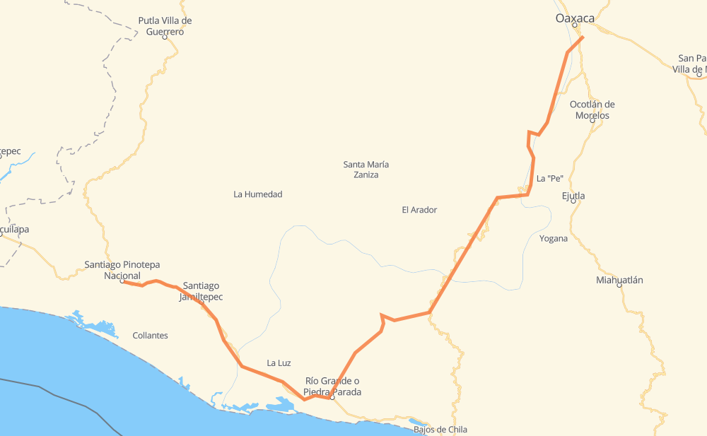
Distance between Santiago Pinotepa Nacional and San Antonio de la Cal
The distance from Santiago Pinotepa Nacional to San Antonio de la Cal is 327 kilometers by road. Road takes approximately 4 hours and 15 minutes and goes through Zimatlán de Álvarez, Villa de Zaachila, Santiago Jamiltepec, San Andrés Huaxpaltepec, San José del Progreso, Santa Rosa de Lima and Santa Catarina Juquila.
| Shortest distance by air | 163 km ✈️ |
| Car route length | 327 km 🚗 |
| Driving time | 4 h 15 min |
| Fuel amount | 26.2 L |
| Fuel cost | 39 GBP |
| Point | Distance | Time | Fuel | |
| Santiago Pinotepa Nacional | 0 km | 00 min | 0.0 L | |
|
MEX 200 24 km, 17 min
|
||||
| Santiago Jamiltepec | 24 km | 17 min | 0.6 L | |
|
MEX 200 37 km, 27 min
|
||||
| San José del Progreso | 61 km | 45 min | 4.0 L | |
|
MEX 200 59 km, 40 min
|
||||
| Santa Catarina Juquila | 121 km | 1 h 26 min | 8.2 L | |
|
35 km, 25 min
|
||||
| Santa María Yolotepec | 156 km | 1 h 52 min | 11.6 L | |
|
MEX 131 36 km, 27 min
|
||||
| San Pedro Juchatengo | 192 km | 2 h 19 min | 14.5 L | |
|
MEX 131 71 km, 51 min
|
||||
| Villa Sola de Vega | 263 km | 3 h 11 min | 21.0 L | |
|
MEX 131 61 km, 43 min
|
||||
| Zimatlán de Álvarez | 323 km | 3 h 54 min | 25.8 L | |
|
MEX 131 11 km, 07 min
|
||||
| Villa de Zaachila | 334 km | 4 h 02 min | 26.5 L | |
|
MEX 175 14 km, 12 min
|
||||
| San Antonio de la Cal | 348 km | 4 h 14 min | 27.8 L | |
Frequently Asked Questions
How much does it cost to drive from Santiago Pinotepa Nacional to San Antonio de la Cal?
Fuel cost: 39 GBP
This fuel cost is calculated as: (Route length 327 km / 100 km) * (Fuel consumption 8 L/100 km) * (Fuel price 1.49 GBP / L)
You can adjust fuel consumption and fuel price here.
How long is a car ride from Santiago Pinotepa Nacional to San Antonio de la Cal?
Driving time: 4 h 15 min
This time is calculated for driving at the maximum permitted speed, taking into account traffic rules restrictions.
- 78 km with a maximum speed 96 km/h = 48 min
- 264 km with a maximum speed 80 km/h = 3 h 17 min
- 4 km with a maximum speed 50 km/h = 5 min
- 2 km with a maximum speed 40 km/h = 3 min
The calculated driving time does not take into account intermediate stops and traffic jams.
How far is Santiago Pinotepa Nacional to San Antonio de la Cal by land?
The distance between Santiago Pinotepa Nacional and San Antonio de la Cal is 327 km by road.
Precise satellite coordinates of highways were used for this calculation. The start and finish points are the centers of Santiago Pinotepa Nacional and San Antonio de la Cal respectively.
How far is Santiago Pinotepa Nacional to San Antonio de la Cal by plane?
The shortest distance (air line, as the crow flies) between Santiago Pinotepa Nacional and San Antonio de la Cal is 163 km.
This distance is calculated using the Haversine formula as a great-circle distance between two points on the surface of a sphere. The start and finish points are the centers of Santiago Pinotepa Nacional and San Antonio de la Cal respectively. Actual distance between airports may be different.
How many hours is Santiago Pinotepa Nacional from San Antonio de la Cal by plane?
Boeing 737 airliner needs 12 min to cover the distance of 163 km at a cruising speed of 800 km/h.
Small plane "Cessna 172" needs 44 min to flight this distance at average speed of 220 km/h.
This time is approximate and do not take into account takeoff and landing times, airport location and other real world factors.
How long is a helicopter ride from Santiago Pinotepa Nacional to San Antonio de la Cal?
Fast helicopter "Eurocopter AS350" or "Hughes OH-6 Cayuse" need 40 min to cover the distance of 163 km at a cruising speed of 240 km/h.
Popular "Robinson R44" needs 46 min to flight this distance at average speed of 210 km/h.
This time is approximate and do not take into account takeoff and landing times, aerodrome location and other real world factors.
What city is halfway between Santiago Pinotepa Nacional and San Antonio de la Cal?
The halfway point between Santiago Pinotepa Nacional and San Antonio de la Cal is Santa María Yolotepec. It is located about 8 km from the exact midpoint by road.
The distance from Santa María Yolotepec to Santiago Pinotepa Nacional is 156 km and driving will take about 1 h 52 min. The road between Santa María Yolotepec and San Antonio de la Cal has length 172 km and will take approximately 2 h 23 min.
The other cities located close to halfway point:
Where is Santiago Pinotepa Nacional in relation to San Antonio de la Cal?
Santiago Pinotepa Nacional is located 163 km south-west of San Antonio de la Cal.
Santiago Pinotepa Nacional has geographic coordinates: latitude 16.33805, longitude -98.05028.
San Antonio de la Cal has geographic coordinates: latitude 17.02833, longitude -96.70056.
Which highway goes from Santiago Pinotepa Nacional to San Antonio de la Cal?
The route from Santiago Pinotepa Nacional to San Antonio de la Cal follows MEX 131, MEX 200.
Other minor sections pass along the road:
- MEX 175: 1 km