Distance between Santo Antônio de Jesus and Juazeiro
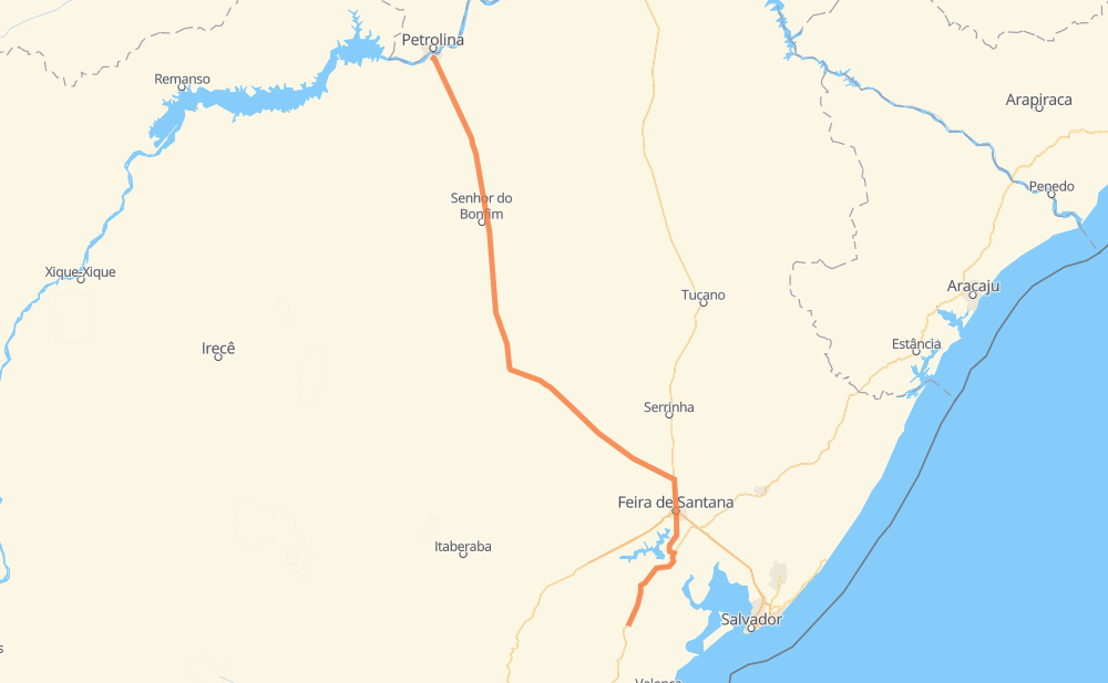
The distance from Santo Antônio de Jesus to Juazeiro is 496 kilometers by road. Road takes approximately 5 hours and 56 minutes and goes through Parque Panorama, Capim Grosso, Capoeiruçu, São Cristovão, Peixe, Barracas and Nova Represa.
| Shortest distance by air | 416 km ✈️ |
| Car route length | 496 km 🚗 |
| Driving time | 5 h 56 min |
| Fuel amount | 39.7 L |
| Fuel cost | 59.2 GBP |
| Point | Distance | Time | Fuel | |
| -12.96894, -39.26092 | 0 km | 00 min | 0.0 L | |
|
3 km, 02 min
|
||||
| Taitinga | 3 km | 02 min | 0.4 L | |
|
BA-046 BR-101 44 km, 34 min
|
||||
| Tabuleiro da Baiana | 47 km | 36 min | 3.7 L | |
|
BR-101 17 km, 13 min
|
||||
| Capoeiruçu | 64 km | 49 min | 5.2 L | |
|
BR-101 BA-502 35 km, 22 min
|
||||
| Parque Panorama | 99 km | 1 h 12 min | 8.0 L | |
|
BA-502 BR-116 24 km, 19 min
|
||||
| São Cristovão | 122 km | 1 h 31 min | 9.4 L | |
|
BR-116 BR-324 152 km, 1 h 38 min
|
||||
| Capim Grosso | 275 km | 3 h 09 min | 20.8 L | |
|
BR-407 26 km, 18 min
|
||||
| Barracas | 300 km | 3 h 28 min | 23.9 L | |
|
BR-407 16 km, 11 min
|
||||
| Nova Represa | 316 km | 3 h 40 min | 24.5 L | |
|
BR-407 73 km, 50 min
|
||||
| Estiva | 389 km | 4 h 30 min | 30.6 L | |
|
BR-407 112 km, 1 h 25 min
|
||||
| Juazeiro | 501 km | 5 h 55 min | 39.6 L | |
Frequently Asked Questions
How much does it cost to drive from Santo Antônio de Jesus to Juazeiro?
Fuel cost: 59.2 GBP
This fuel cost is calculated as: (Route length 496 km / 100 km) * (Fuel consumption 8 L/100 km) * (Fuel price 1.49 GBP / L)
You can adjust fuel consumption and fuel price here.
How long is a car ride from Santo Antônio de Jesus to Juazeiro?
Driving time: 5 h 56 min
This time is calculated for driving at the maximum permitted speed, taking into account traffic rules restrictions.
- 211 km with a maximum speed 96 km/h = 2 h 12 min
- 267 km with a maximum speed 80 km/h = 3 h 20 min
- 20 km with a maximum speed 60 km/h = 19 min
- 3 km with a maximum speed 50 km/h = 3 min
The calculated driving time does not take into account intermediate stops and traffic jams.
How far is Santo Antônio de Jesus to Juazeiro by land?
The distance between Santo Antônio de Jesus and Juazeiro is 496 km by road.
Precise satellite coordinates of highways were used for this calculation. The start and finish points are the centers of Santo Antônio de Jesus and Juazeiro respectively.
How far is Santo Antônio de Jesus to Juazeiro by plane?
The shortest distance (air line, as the crow flies) between Santo Antônio de Jesus and Juazeiro is 416 km.
This distance is calculated using the Haversine formula as a great-circle distance between two points on the surface of a sphere. The start and finish points are the centers of Santo Antônio de Jesus and Juazeiro respectively. Actual distance between airports may be different.
How many hours is Santo Antônio de Jesus from Juazeiro by plane?
Boeing 737 airliner needs 31 min to cover the distance of 416 km at a cruising speed of 800 km/h.
Small plane "Cessna 172" needs 1 h 53 min to flight this distance at average speed of 220 km/h.
This time is approximate and do not take into account takeoff and landing times, airport location and other real world factors.
How long is a helicopter ride from Santo Antônio de Jesus to Juazeiro?
Fast helicopter "Eurocopter AS350" or "Hughes OH-6 Cayuse" need 1 h 44 min to cover the distance of 416 km at a cruising speed of 240 km/h.
Popular "Robinson R44" needs 1 h 58 min to flight this distance at average speed of 210 km/h.
This time is approximate and do not take into account takeoff and landing times, aerodrome location and other real world factors.
What city is halfway between Santo Antônio de Jesus and Juazeiro?
The halfway point between Santo Antônio de Jesus and Juazeiro is Capim Grosso. It is located about 26 km from the exact midpoint by road.
The distance from Capim Grosso to Santo Antônio de Jesus is 275 km and driving will take about 3 h 9 min. The road between Capim Grosso and Juazeiro has length 222 km and will take approximately 2 h 46 min.
The other cities located close to halfway point:
Where is Santo Antônio de Jesus in relation to Juazeiro?
Santo Antônio de Jesus is located 416 km south-east of Juazeiro.
Santo Antônio de Jesus has geographic coordinates: latitude -12.96894, longitude -39.26092.
Juazeiro has geographic coordinates: latitude -9.4337, longitude -40.50682.
Which highway goes from Santo Antônio de Jesus to Juazeiro?
The route from Santo Antônio de Jesus to Juazeiro follows BR-407, BR-324.
Other minor sections pass along the road:
- BR-101: 66 km
- BA-502: 31 km
- BR-116: 23 km
- BA-046: 1 km