Distance between Tagoloan and Busuanga
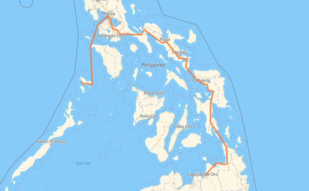
The distance from Tagoloan to Busuanga is 1,748 kilometers by road including 52 kilometers on motorways. Road takes approximately 37 hours and 8 minutes and goes through Gingoog, Butuan, Surigao City, Tacloban, Catbalogan, Calbayog and Sorsogon City.
| Shortest distance by air | 662 km ✈️ |
| Car route length | 1,748 km 🚗 |
| Driving time | 37 h 8 min |
| Fuel amount | 139.8 L |
| Fuel cost | 208.3 GBP |
| Point | Distance | Time | Fuel | |
| Tagoloan | 0 km | 00 min | 0.0 L | |
|
9 955 77 km, 55 min
|
||||
| Gingoog | 77 km | 55 min | 5.7 L | |
|
9 73 km, 1 h 12 min
|
||||
| Butuan | 150 km | 2 h 07 min | 11.8 L | |
|
9 AH26 120 km, 1 h 34 min
|
||||
| Surigao City | 270 km | 3 h 42 min | 21.5 L | |
|
1 228 km, 3 h 50 min
|
||||
| Tacloban | 499 km | 7 h 32 min | 39.6 L | |
|
1 100 km, 1 h 22 min
|
||||
| Catbalogan | 599 km | 8 h 55 min | 46.8 L | |
|
1 83 km, 1 h 14 min
|
||||
| Calbayog | 682 km | 10 h 09 min | 52.5 L | |
|
1 145 km, 2 h 42 min
|
||||
| Sorsogon City | 827 km | 12 h 52 min | 66.0 L | |
|
1 81 km, 59 min
|
||||
| Ligao | 908 km | 13 h 51 min | 72.3 L | |
|
1 61 km, 51 min
|
||||
| Naga | 970 km | 14 h 43 min | 77.2 L | |
|
1 301 km, 3 h 55 min
|
||||
| San Pablo | 1,270 km | 18 h 38 min | 101.1 L | |
|
1 AH26 34 km, 25 min
|
||||
| Calamba | 1,304 km | 19 h 04 min | 103.9 L | |
|
E2 6 km, 03 min
|
||||
| Cabuyao | 1,310 km | 19 h 07 min | 104.8 L | |
|
E2 3 km, 01 min
|
||||
| Santa Rosa | 1,314 km | 19 h 09 min | 104.9 L | |
|
E2 7 km, 03 min
|
||||
| Biñan | 1,320 km | 19 h 13 min | 105.3 L | |
|
E2 5 km, 03 min
|
||||
| San Pedro | 1,326 km | 19 h 17 min | 105.9 L | |
|
E2 422 km, 17 h 50 min
|
||||
| Busuanga | 1,748 km | 37 h 07 min | 138.3 L | |
Hotels of Busuanga
Frequently Asked Questions
How much does it cost to drive from Tagoloan to Busuanga?
Fuel cost: 208.3 GBP
This fuel cost is calculated as: (Route length 1,748 km / 100 km) * (Fuel consumption 8 L/100 km) * (Fuel price 1.49 GBP / L)
You can adjust fuel consumption and fuel price here.
How long is a car ride from Tagoloan to Busuanga?
Driving time: 37 h 8 min
This time is calculated for driving at the maximum permitted speed, taking into account traffic rules restrictions.
- 45 km with a maximum speed 100 km/h = 27 min
- 177 km with a maximum speed 96 km/h = 1 h 50 min
- 5 km with a maximum speed 90 km/h = 3 min
- 852 km with a maximum speed 80 km/h = 10 h 39 min
- 19 km with a maximum speed 70 km/h = 16 min
- 205 km with a maximum speed 60 km/h = 3 h 25 min
- 46 km with a maximum speed 50 km/h = 54 min
- 13 km with a maximum speed 40 km/h = 18 min
- 3 km with a maximum speed 30 km/h = 6 min
- 382 km with a maximum speed 20 km/h = 19 h 5 min
The calculated driving time does not take into account intermediate stops and traffic jams.
How far is Tagoloan to Busuanga by land?
The distance between Tagoloan and Busuanga is 1,748 km by road including 52 km on motorways.
Precise satellite coordinates of highways were used for this calculation. The start and finish points are the centers of Tagoloan and Busuanga respectively.
How far is Tagoloan to Busuanga by plane?
The shortest distance (air line, as the crow flies) between Tagoloan and Busuanga is 662 km.
This distance is calculated using the Haversine formula as a great-circle distance between two points on the surface of a sphere. The start and finish points are the centers of Tagoloan and Busuanga respectively. Actual distance between airports may be different.
How many hours is Tagoloan from Busuanga by plane?
Boeing 737 airliner needs 49 min to cover the distance of 662 km at a cruising speed of 800 km/h.
Small plane "Cessna 172" needs 3 h to flight this distance at average speed of 220 km/h.
This time is approximate and do not take into account takeoff and landing times, airport location and other real world factors.
How long is a helicopter ride from Tagoloan to Busuanga?
Fast helicopter "Eurocopter AS350" or "Hughes OH-6 Cayuse" need 2 h 45 min to cover the distance of 662 km at a cruising speed of 240 km/h.
Popular "Robinson R44" needs 3 h 9 min to flight this distance at average speed of 210 km/h.
This time is approximate and do not take into account takeoff and landing times, aerodrome location and other real world factors.
What city is halfway between Tagoloan and Busuanga?
The halfway point between Tagoloan and Busuanga is Washington. It is located about 1 km from the exact midpoint by road.
The distance from Washington to Tagoloan is 875 km and driving will take about 13 h 25 min. The road between Washington and Busuanga has length 873 km and will take approximately 23 h 42 min.
The other cities located close to halfway point:
Where is Tagoloan in relation to Busuanga?
Tagoloan is located 662 km south-east of Busuanga.
Tagoloan has geographic coordinates: latitude 8.53917, longitude 124.75385.
Busuanga has geographic coordinates: latitude 12.13321, longitude 119.93614.
Which highway goes from Tagoloan to Busuanga?
The route from Tagoloan to Busuanga follows AH26, 1.
Other minor sections pass along the road:
- 68: 93 km
- 9: 88 km
- 955: 69 km
- E2: 51 km
- 691: 39 km
- 609: 8 km
- 120: 5 km
- 673: 4 km
- 608: 3 km
- 190: 2 km