Distance between Tlaxcala and Yaxdzonot
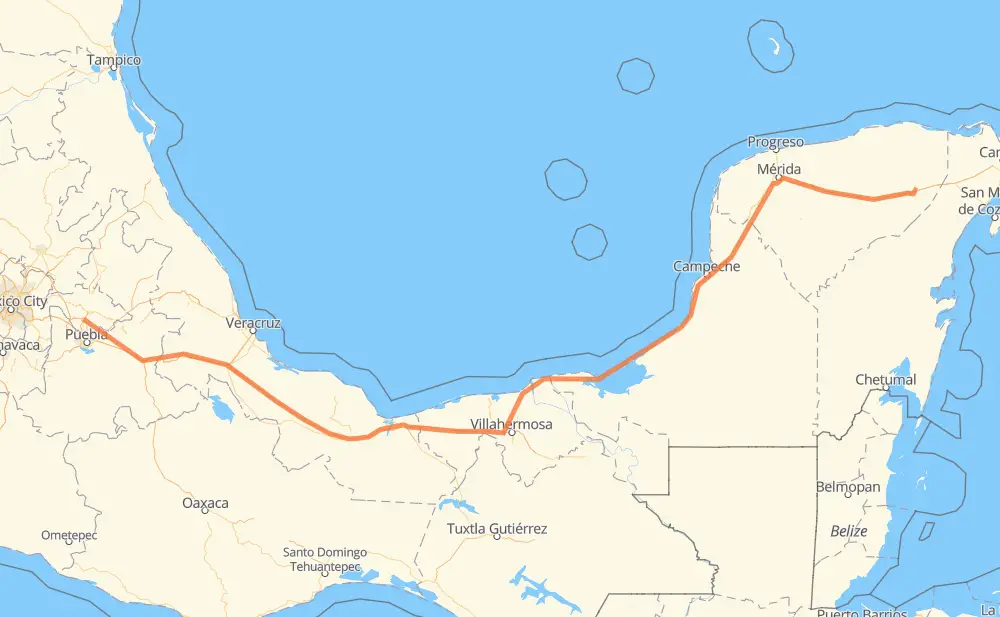
The distance from Tlaxcala to Yaxdzonot is 1,401 kilometers by road including 729 kilometers on motorways. Road takes approximately 15 hours and 34 minutes and goes through Orizaba, Mérida, Kanasín, San Francisco Ocotlán (Ocotlán), Acatzingo de Hidalgo, Palmarito Tochapan and Cuacnopalan.
| Shortest distance by air | 1,091 km ✈️ |
| Car route length | 1,401 km 🚗 |
| Driving time | 15 h 34 min |
| Fuel amount | 112.1 L |
| Fuel cost | 167 GBP |
| Toll roads cost | 919 + ? MXN |
| Point | Distance | Time | Fuel | |
| Tlaxcala | 0 km | 00 min | 0.0 L | |
|
MEX 119D 23 km, 16 min
|
||||
| San Francisco Ocotlán (Ocotlán) | 23 km | 16 min | 1.8 L | |
|
MEX 150D 63 km, 40 min
|
||||
| Acatzingo de Hidalgo | 86 km | 57 min | 6.4 L | |
|
MEX 150D 14 km, 09 min
|
||||
| Palmarito Tochapan | 100 km | 1 h 06 min | 7.7 L | |
|
MEX 150D 13 km, 09 min
|
||||
| Cuacnopalan | 112 km | 1 h 15 min | 8.2 L | |
|
MEX 150D 31 km, 22 min
|
||||
| Maltrata | 143 km | 1 h 38 min | 11.4 L | |
|
MEX 150D 32 km, 23 min
|
||||
| Orizaba | 175 km | 2 h 01 min | 13.7 L | |
|
MEX 150D MEX 180 1,034 km, 11 h 18 min
|
||||
| Mérida | 1,209 km | 13 h 20 min | 96.3 L | |
|
24 km, 17 min
|
||||
| Kanasín | 1,233 km | 13 h 38 min | 97.1 L | |
|
MEX 180 MEX 180D 171 km, 1 h 56 min
|
||||
| Yaxdzonot | 1,405 km | 15 h 34 min | 112.3 L | |
Frequently Asked Questions
How many toll booths are there from Tlaxcala to Yaxdzonot?
There are 14 toll booths between Tlaxcala and Yaxdzonot: Fortín, Cuitláhuac, Cosamaloapan, Acayucan, Antonio Dovali, Zacatelco, Amozoc, Esperanza 27, Sánchez Magallanes, Villahermosa Nacajuca, Zacatal, Unidad, Seybaplaya and Pisté.
How much does the toll booths cost from Tlaxcala to Yaxdzonot?
Toll roads cost: Zacatelco (?) + Amozoc (72 MXN) + Esperanza 27 (140 MXN) + Fortín (33 MXN) + Cuitláhuac (114 MXN) + Cosamaloapan (229 MXN) + Acayucan (?) + Antonio Dovali (20 MXN) + Sánchez Magallanes (82 MXN) + Villahermosa Nacajuca (62 MXN) + Zacatal (90 MXN) + Unidad (?) + Seybaplaya (77 MXN) + Pisté (?) = 919 + ? MXN
How much does it cost to drive from Tlaxcala to Yaxdzonot?
Fuel cost: 167 GBP
This fuel cost is calculated as: (Route length 1,401 km / 100 km) * (Fuel consumption 8 L/100 km) * (Fuel price 1.49 GBP / L)
You can adjust fuel consumption and fuel price here.
Toll roads cost: 919 + ? MXN
How long is a car ride from Tlaxcala to Yaxdzonot?
Driving time: 15 h 34 min
This time is calculated for driving at the maximum permitted speed, taking into account traffic rules restrictions.
- 232 km with a maximum speed 110 km/h = 2 h 6 min
- 351 km with a maximum speed 100 km/h = 3 h 30 min
- 185 km with a maximum speed 96 km/h = 1 h 55 min
- 109 km with a maximum speed 90 km/h = 1 h 12 min
- 499 km with a maximum speed 80 km/h = 6 h 14 min
- 5 km with a maximum speed 70 km/h = 4 min
- 20 km with a maximum speed 50 km/h = 24 min
- 3 km with a maximum speed 40 km/h = 4 min
- 1 km with a maximum speed 20 km/h = 2 min
The calculated driving time does not take into account intermediate stops and traffic jams.
How far is Tlaxcala to Yaxdzonot by land?
The distance between Tlaxcala and Yaxdzonot is 1,401 km by road including 729 km on motorways.
Precise satellite coordinates of highways were used for this calculation. The start and finish points are the centers of Tlaxcala and Yaxdzonot respectively.
How far is Tlaxcala to Yaxdzonot by plane?
The shortest distance (air line, as the crow flies) between Tlaxcala and Yaxdzonot is 1,091 km.
This distance is calculated using the Haversine formula as a great-circle distance between two points on the surface of a sphere. The start and finish points are the centers of Tlaxcala and Yaxdzonot respectively. Actual distance between airports may be different.
How many hours is Tlaxcala from Yaxdzonot by plane?
Boeing 737 airliner needs 1 h 21 min to cover the distance of 1,091 km at a cruising speed of 800 km/h.
Small plane "Cessna 172" needs 4 h 57 min to flight this distance at average speed of 220 km/h.
This time is approximate and do not take into account takeoff and landing times, airport location and other real world factors.
How long is a helicopter ride from Tlaxcala to Yaxdzonot?
Fast helicopter "Eurocopter AS350" or "Hughes OH-6 Cayuse" need 4 h 32 min to cover the distance of 1,091 km at a cruising speed of 240 km/h.
Popular "Robinson R44" needs 5 h 11 min to flight this distance at average speed of 210 km/h.
This time is approximate and do not take into account takeoff and landing times, aerodrome location and other real world factors.
What city is halfway between Tlaxcala and Yaxdzonot?
The halfway point between Tlaxcala and Yaxdzonot is Frontera. It is located about 48 km from the exact midpoint by road.
The distance from Frontera to Tlaxcala is 748 km and driving will take about 8 h. The road between Frontera and Yaxdzonot has length 653 km and will take approximately 7 h 33 min.
The other cities located close to halfway point:
Where is Tlaxcala in relation to Yaxdzonot?
Tlaxcala is located 1,091 km west of Yaxdzonot.
Tlaxcala has geographic coordinates: latitude 19.31671, longitude -98.23861.
Yaxdzonot has geographic coordinates: latitude 20.80749, longitude -87.9189.
Which highway goes from Tlaxcala to Yaxdzonot?
The route from Tlaxcala to Yaxdzonot follows MEX 180, MEX 180D, MEX 150D, MEX 145D.
Other minor sections pass along the road:
- MEX 119D: 17 km