Distance between Toronto SD and Scotia NE
The distance from Toronto to Scotia is 519 kilometers by road including 200 kilometers on motorways. Road takes approximately 5 hours and 9 minutes and goes through Brookings, Sioux Falls, Vermillion and Yankton.
| Shortest distance by air | 384 km ✈️ |
| Car route length | 519 km 🚗 |
| Driving time | 5 h 9 min |
| Fuel amount | 41.5 L |
| Fuel cost | 61.8 GBP |
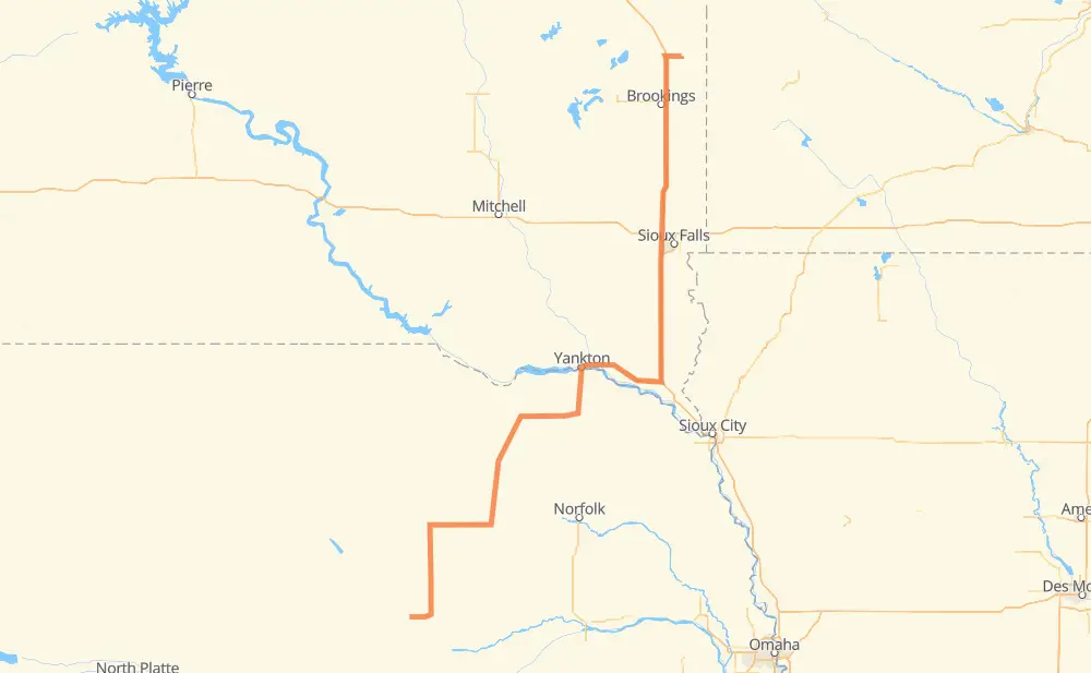
| Point | Distance | Time | Fuel | |
| Toronto | 0 km | 00 min | 0.0 L | |
|
SD 28 I 29 38 km, 21 min
|
||||
| Brookings | 38 km | 21 min | 2.9 L | |
|
I 29 87 km, 46 min
|
||||
| Sioux Falls | 125 km | 1 h 08 min | 9.4 L | |
|
I 29 94 km, 52 min
|
||||
| Vermillion | 219 km | 2 h 00 min | 17.5 L | |
|
SD 50 15 km, 09 min
|
||||
| Meckling | 234 km | 2 h 10 min | 18.1 L | |
|
SD 50 13 km, 08 min
|
||||
| Gayville | 248 km | 2 h 18 min | 19.4 L | |
|
SD 50 12 km, 07 min
|
||||
| Yankton | 259 km | 2 h 26 min | 20.4 L | |
|
SD 50 NE 84 122 km, 1 h 17 min
|
||||
| Neligh | 382 km | 3 h 43 min | 29.5 L | |
|
NE 14 NE 70 111 km, 1 h 09 min
|
||||
| Greeley | 493 km | 4 h 53 min | 38.5 L | |
|
US 281 NE 22 26 km, 16 min
|
||||
| Scotia | 519 km | 5 h 09 min | 41.4 L | |
Frequently Asked Questions
How much does it cost to drive from Toronto to Scotia?
Fuel cost: 61.8 GBP
This fuel cost is calculated as: (Route length 519 km / 100 km) * (Fuel consumption 8 L/100 km) * (Fuel price 1.49 GBP / L)
You can adjust fuel consumption and fuel price here.
How long is a car ride from Toronto to Scotia?
Driving time: 5 h 9 min
This time is calculated for driving at the maximum permitted speed, taking into account traffic rules restrictions.
- 179 km with a maximum speed 112 km/h = 1 h 36 min
- 20 km with a maximum speed 105 km/h = 11 min
- 295 km with a maximum speed 96 km/h = 3 h 4 min
- 7 km with a maximum speed 89 km/h = 4 min
- 15 km with a maximum speed 80 km/h = 10 min
- 2 km with a maximum speed 72 km/h = 1 min
The calculated driving time does not take into account intermediate stops and traffic jams.
How far is Toronto to Scotia by land?
The distance between Toronto and Scotia is 519 km by road including 200 km on motorways.
Precise satellite coordinates of highways were used for this calculation. The start and finish points are the centers of Toronto and Scotia respectively.
How far is Toronto to Scotia by plane?
The shortest distance (air line, as the crow flies) between Toronto and Scotia is 384 km.
This distance is calculated using the Haversine formula as a great-circle distance between two points on the surface of a sphere. The start and finish points are the centers of Toronto and Scotia respectively. Actual distance between airports may be different.
How many hours is Toronto from Scotia by plane?
Boeing 737 airliner needs 28 min to cover the distance of 384 km at a cruising speed of 800 km/h.
Small plane "Cessna 172" needs 1 h 44 min to flight this distance at average speed of 220 km/h.
This time is approximate and do not take into account takeoff and landing times, airport location and other real world factors.
How long is a helicopter ride from Toronto to Scotia?
Fast helicopter "Eurocopter AS350" or "Hughes OH-6 Cayuse" need 1 h 36 min to cover the distance of 384 km at a cruising speed of 240 km/h.
Popular "Robinson R44" needs 1 h 49 min to flight this distance at average speed of 210 km/h.
This time is approximate and do not take into account takeoff and landing times, aerodrome location and other real world factors.
What city is halfway between Toronto and Scotia?
Where is Toronto in relation to Scotia?
Toronto is located 384 km north-east of Scotia.
Toronto has geographic coordinates: latitude 44.57302, longitude -96.64255.
Scotia has geographic coordinates: latitude 41.4664, longitude -98.70313.
Which highway goes from Toronto to Scotia?
The route from Toronto to Scotia follows I 29.
Other minor sections pass along the road:
- NE 70: 61 km
- US 281: 56 km
- SD 50: 53 km
- NE 14: 42 km
- NE 84: 38 km
- US 81: 29 km
- NE 13: 28 km
- NE 22: 14 km
- US 20: 11 km
- NE 91: 10 km
- SD 28: 10 km
- US 18: 4 km