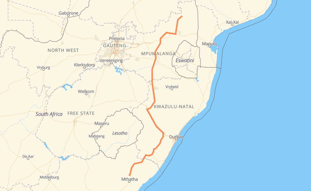
Distance between Tsolo and Ludlow
The distance from Tsolo to Ludlow is 1,077 kilometers by road including 144 kilometers on motorways. Road takes approximately 12 hours and 7 minutes and goes through Pietermaritzburg, Mount Frere, Mount Ayliff, Penhalonga, Richmond, Baynesfield and Westgate.
| Shortest distance by air | 779 km ✈️ |
| Car route length | 1,077 km 🚗 |
| Driving time | 12 h 7 min |
| Fuel amount | 86.1 L |
| Fuel cost | 128.3 GBP |
| Point | Distance | Time | Fuel | |
| Tsolo | 0 km | 00 min | 0.0 L | |
|
R396 N2 68 km, 45 min
|
||||
| Mount Frere | 68 km | 45 min | 4.8 L | |
|
N2 50 km, 33 min
|
||||
| Mount Ayliff | 117 km | 1 h 19 min | 8.6 L | |
|
N2 R56 174 km, 1 h 54 min
|
||||
| Richmond | 291 km | 3 h 13 min | 22.7 L | |
|
R56 13 km, 09 min
|
||||
| Baynesfield | 304 km | 3 h 22 min | 24.2 L | |
|
R56 16 km, 11 min
|
||||
| Westgate | 321 km | 3 h 34 min | 25.5 L | |
|
R56 5 km, 03 min
|
||||
| Scottsville | 325 km | 3 h 37 min | 26.0 L | |
|
R56 2 km, 01 min
|
||||
| Pietermaritzburg | 327 km | 3 h 39 min | 26.1 L | |
|
R103 3 km, 01 min
|
||||
| Town Hill | 330 km | 3 h 40 min | 26.4 L | |
|
R103 N11 753 km, 8 h 26 min
|
||||
| Ludlow | 1,083 km | 12 h 07 min | 86.1 L | |
Frequently Asked Questions
How much does it cost to drive from Tsolo to Ludlow?
Fuel cost: 128.3 GBP
This fuel cost is calculated as: (Route length 1,077 km / 100 km) * (Fuel consumption 8 L/100 km) * (Fuel price 1.49 GBP / L)
You can adjust fuel consumption and fuel price here.
How long is a car ride from Tsolo to Ludlow?
Driving time: 12 h 7 min
This time is calculated for driving at the maximum permitted speed, taking into account traffic rules restrictions.
- 108 km with a maximum speed 112 km/h = 58 min
- 34 km with a maximum speed 100 km/h = 20 min
- 639 km with a maximum speed 96 km/h = 6 h 39 min
- 233 km with a maximum speed 80 km/h = 2 h 54 min
- 9 km with a maximum speed 70 km/h = 7 min
- 24 km with a maximum speed 60 km/h = 24 min
- 34 km with a maximum speed 50 km/h = 40 min
- 2 km with a maximum speed 40 km/h = 2 min
The calculated driving time does not take into account intermediate stops and traffic jams.
How far is Tsolo to Ludlow by land?
The distance between Tsolo and Ludlow is 1,077 km by road including 144 km on motorways.
Precise satellite coordinates of highways were used for this calculation. The start and finish points are the centers of Tsolo and Ludlow respectively.
How far is Tsolo to Ludlow by plane?
The shortest distance (air line, as the crow flies) between Tsolo and Ludlow is 779 km.
This distance is calculated using the Haversine formula as a great-circle distance between two points on the surface of a sphere. The start and finish points are the centers of Tsolo and Ludlow respectively. Actual distance between airports may be different.
How many hours is Tsolo from Ludlow by plane?
Boeing 737 airliner needs 58 min to cover the distance of 779 km at a cruising speed of 800 km/h.
Small plane "Cessna 172" needs 3 h 32 min to flight this distance at average speed of 220 km/h.
This time is approximate and do not take into account takeoff and landing times, airport location and other real world factors.
How long is a helicopter ride from Tsolo to Ludlow?
Fast helicopter "Eurocopter AS350" or "Hughes OH-6 Cayuse" need 3 h 14 min to cover the distance of 779 km at a cruising speed of 240 km/h.
Popular "Robinson R44" needs 3 h 42 min to flight this distance at average speed of 210 km/h.
This time is approximate and do not take into account takeoff and landing times, aerodrome location and other real world factors.
What city is halfway between Tsolo and Ludlow?
The halfway point between Tsolo and Ludlow is Ballengeich. It is located about 38 km from the exact midpoint by road.
The distance from Ballengeich to Tsolo is 576 km and driving will take about 6 h 5 min. The road between Ballengeich and Ludlow has length 500 km and will take approximately 6 h 1 min.
The other cities located close to halfway point:
Where is Tsolo in relation to Ludlow?
Tsolo is located 779 km south-west of Ludlow.
Tsolo has geographic coordinates: latitude -31.30852, longitude 28.75526.
Ludlow has geographic coordinates: latitude -24.66917, longitude 31.27694.
Which highway goes from Tsolo to Ludlow?
The route from Tsolo to Ludlow follows N11, R56, N2, N3, R36.
Other minor sections pass along the road:
- N4: 96 km
- R40: 55 km
- R539: 49 km
- R538: 35 km
- N17: 8 km
- R103: 5 km
- R396: 5 km
- R38: 5 km
- R517: 4 km
- R543: 2 km
- R37: 2 km