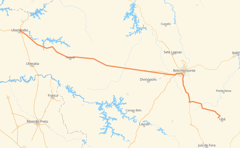
Distance between Ubari and Minas Gerais
The distance from Ubari to Minas Gerais is 765 kilometers by road including 141 kilometers on motorways. Road takes approximately 9 hours and 2 minutes and goes through Conselheiro Lafaiete, Betim, Aconchego da Serra, Alphaville, Vale do Sol, PTB and Pará de Minas.
| Shortest distance by air | 596 km ✈️ |
| Car route length | 765 km 🚗 |
| Driving time | 9 h 2 min |
| Fuel amount | 61.2 L |
| Fuel cost | 91.2 GBP |
| Point | Distance | Time | Fuel | |
| -21.04901, -43.06275 | 0 km | 00 min | 0.0 L | |
|
MG-275 149 km, 1 h 52 min
|
||||
| Conselheiro Lafaiete | 149 km | 1 h 52 min | 21.1 L | |
|
MGC-482 BR-040 65 km, 45 min
|
||||
| Aconchego da Serra | 213 km | 2 h 37 min | 27.2 L | |
|
BR-040 10 km, 06 min
|
||||
| Alphaville | 224 km | 2 h 44 min | 28.2 L | |
|
BR-040 7 km, 04 min
|
||||
| Vale do Sol | 231 km | 2 h 48 min | 28.7 L | |
|
BR-040 36 km, 26 min
|
||||
| PTB | 267 km | 3 h 14 min | 31.8 L | |
|
BR-381 9 km, 05 min
|
||||
| Betim | 275 km | 3 h 20 min | 32.0 L | |
|
BR-262 47 km, 28 min
|
||||
| Pará de Minas | 322 km | 3 h 48 min | 36.0 L | |
|
BR-262 42 km, 23 min
|
||||
| Nova Serrana | 364 km | 4 h 11 min | 39.2 L | |
|
BR-262 89 km, 1 h 09 min
|
||||
| Luz | 453 km | 5 h 21 min | 46.0 L | |
|
BR-262 158 km, 1 h 46 min
|
||||
| Distrito Industrial | 611 km | 7 h 07 min | 59.4 L | |
|
BR-452 172 km, 1 h 54 min
|
||||
| -18.86519, -48.26528 | 784 km | 9 h 02 min | 73.2 L | |
Frequently Asked Questions
How much does it cost to drive from Ubari to Minas Gerais?
Fuel cost: 91.2 GBP
This fuel cost is calculated as: (Route length 765 km / 100 km) * (Fuel consumption 8 L/100 km) * (Fuel price 1.49 GBP / L)
You can adjust fuel consumption and fuel price here.
How long is a car ride from Ubari to Minas Gerais?
Driving time: 9 h 2 min
This time is calculated for driving at the maximum permitted speed, taking into account traffic rules restrictions.
- 107 km with a maximum speed 110 km/h = 58 min
- 3 km with a maximum speed 100 km/h = 1 min
- 328 km with a maximum speed 96 km/h = 3 h 24 min
- 288 km with a maximum speed 80 km/h = 3 h 35 min
- 12 km with a maximum speed 70 km/h = 10 min
- 28 km with a maximum speed 60 km/h = 27 min
- 13 km with a maximum speed 50 km/h = 15 min
- 4 km with a maximum speed 40 km/h = 6 min
- 1 km with a maximum speed 30 km/h = 2 min
The calculated driving time does not take into account intermediate stops and traffic jams.
How far is Ubari to Minas Gerais by land?
The distance between Ubari and Minas Gerais is 765 km by road including 141 km on motorways.
Precise satellite coordinates of highways were used for this calculation. The start and finish points are the centers of Ubari and Minas Gerais respectively.
How far is Ubari to Minas Gerais by plane?
The shortest distance (air line, as the crow flies) between Ubari and Minas Gerais is 596 km.
This distance is calculated using the Haversine formula as a great-circle distance between two points on the surface of a sphere. The start and finish points are the centers of Ubari and Minas Gerais respectively. Actual distance between airports may be different.
How many hours is Ubari from Minas Gerais by plane?
Boeing 737 airliner needs 44 min to cover the distance of 596 km at a cruising speed of 800 km/h.
Small plane "Cessna 172" needs 2 h 42 min to flight this distance at average speed of 220 km/h.
This time is approximate and do not take into account takeoff and landing times, airport location and other real world factors.
How long is a helicopter ride from Ubari to Minas Gerais?
Fast helicopter "Eurocopter AS350" or "Hughes OH-6 Cayuse" need 2 h 29 min to cover the distance of 596 km at a cruising speed of 240 km/h.
Popular "Robinson R44" needs 2 h 50 min to flight this distance at average speed of 210 km/h.
This time is approximate and do not take into account takeoff and landing times, aerodrome location and other real world factors.
What city is halfway between Ubari and Minas Gerais?
The halfway point between Ubari and Minas Gerais is Novais de Baixo. It is located about 5 km from the exact midpoint by road.
The distance from Novais de Baixo to Ubari is 377 km and driving will take about 4 h 20 min. The road between Novais de Baixo and Minas Gerais has length 388 km and will take approximately 4 h 41 min.
The other cities located close to halfway point:
Where is Ubari in relation to Minas Gerais?
Ubari is located 596 km south-east of Minas Gerais.
Ubari has geographic coordinates: latitude -21.04901, longitude -43.06275.
Minas Gerais has geographic coordinates: latitude -18.86519, longitude -48.26528.
Which highway goes from Ubari to Minas Gerais?
The route from Ubari to Minas Gerais follows BR-262, BR-452.
Other minor sections pass along the road:
- BR-040: 92 km
- MG-275: 48 km
- MGC-482: 44 km
- BR-482: 44 km
- MG-124: 40 km
- BR-381: 23 km
- BR-356: 19 km
- MG-132: 14 km
- BR-354: 12 km
- MG-280: 12 km
- BR-050: 7 km
- BR-365: 4 km