Distance between Uruapan and Seyé
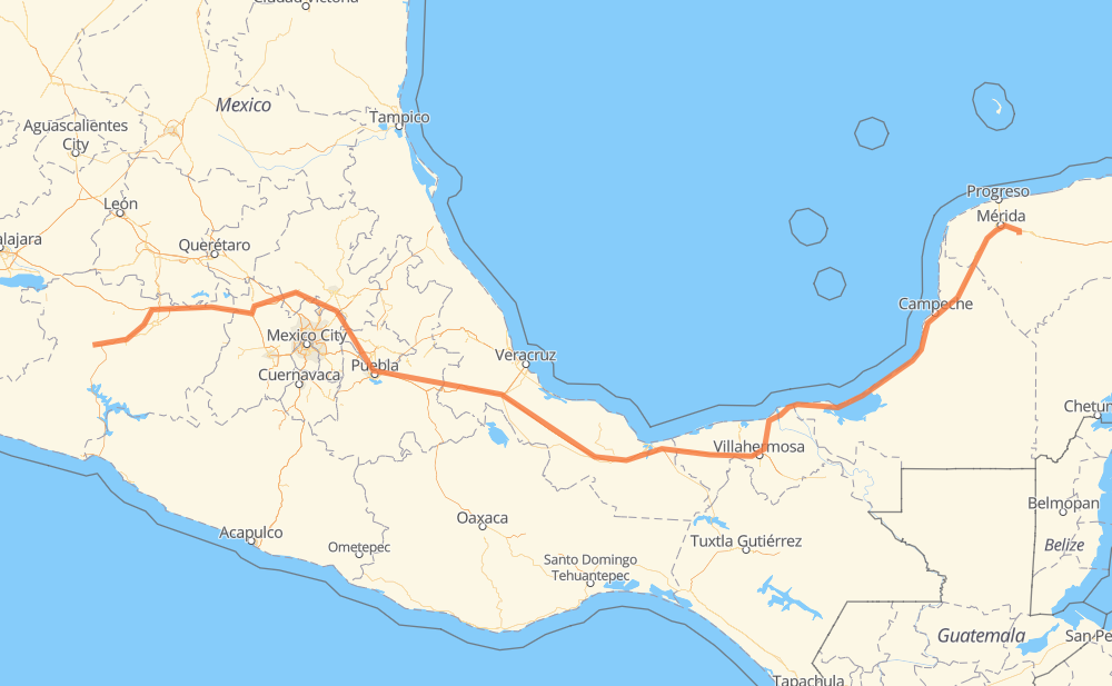
The distance from Uruapan to Seyé is 1,735 kilometers by road including 1,112 kilometers on motorways. Road takes approximately 19 hours and 4 minutes and goes through Orizaba, Mérida, Kanasín, Ziracuaretiro, Pátzcuaro, Maravatio and Pastores.
| Shortest distance by air | 1,334 km ✈️ |
| Car route length | 1,735 km 🚗 |
| Driving time | 19 h 4 min |
| Fuel amount | 138.8 L |
| Fuel cost | 206.8 GBP |
| Toll roads cost | 1,187 + ? MXN |
| Point | Distance | Time | Fuel | |
| Uruapan | 0 km | 00 min | 0.0 L | |
|
MEX 14D 17 km, 12 min
|
||||
| Ziracuaretiro | 17 km | 12 min | 1.0 L | |
|
MEX 14D 36 km, 24 min
|
||||
| Pátzcuaro | 52 km | 36 min | 3.9 L | |
|
MEX 14D MEX 15D 148 km, 1 h 30 min
|
||||
| Maravatio | 201 km | 2 h 07 min | 15.7 L | |
|
MEX 15D 116 km, 1 h 16 min
|
||||
| Jilotepec de Molina Enriquez | 316 km | 3 h 23 min | 24.9 L | |
|
MEX M40D 180 km, 1 h 53 min
|
||||
| Santa María Moyotzingo | 496 km | 5 h 17 min | 39.5 L | |
|
MEX 150D 171 km, 1 h 58 min
|
||||
| Orizaba | 667 km | 7 h 15 min | 53.1 L | |
|
MEX 150D MEX 180 1,034 km, 11 h 18 min
|
||||
| Mérida | 1,701 km | 18 h 34 min | 135.7 L | |
|
18 km, 12 min
|
||||
| Kanasín | 1,719 km | 18 h 47 min | 136.4 L | |
|
MEX 180 20 km, 17 min
|
||||
| Seyé | 1,738 km | 19 h 04 min | 138.6 L | |
Frequently Asked Questions
How many toll booths are there from Uruapan to Seyé?
There are 24 toll booths between Uruapan and Seyé: Fortín, Cuitláhuac, Cosamaloapan, Acayucan, Antonio Dovali, Zurumucapio, Zirahuen, Chapultepec km 58+100, Cuto, Zinapecuaro, Contepec, Atlacomulco — Maravatio, Atlacomulco 2, San Martin Texmelucan, San Martín, Viaducto Elevado de Puebla, Amozoc, Esperanza 27, Sánchez Magallanes, Villahermosa Nacajuca, Zacatal, Unidad, Seybaplaya and Copandaro.
How much does the toll booths cost from Uruapan to Seyé?
Toll roads cost: Zurumucapio (?) + Zirahuen (?) + Chapultepec km 58+100 (?) + Cuto (?) + Copandaro (15 MXN) + Zinapecuaro (161 MXN) + Contepec (?) + Atlacomulco — Maravatio (50 MXN) + Atlacomulco 2 (?) + San Martin Texmelucan (?) + San Martín (42 MXN) + Viaducto Elevado de Puebla (?) + Amozoc (72 MXN) + Esperanza 27 (140 MXN) + Fortín (33 MXN) + Cuitláhuac (114 MXN) + Cosamaloapan (229 MXN) + Acayucan (?) + Antonio Dovali (20 MXN) + Sánchez Magallanes (82 MXN) + Villahermosa Nacajuca (62 MXN) + Zacatal (90 MXN) + Unidad (?) + Seybaplaya (77 MXN) = 1,187 + ? MXN
How much does it cost to drive from Uruapan to Seyé?
Fuel cost: 206.8 GBP
This fuel cost is calculated as: (Route length 1,735 km / 100 km) * (Fuel consumption 8 L/100 km) * (Fuel price 1.49 GBP / L)
You can adjust fuel consumption and fuel price here.
Toll roads cost: 1,187 + ? MXN
How long is a car ride from Uruapan to Seyé?
Driving time: 19 h 4 min
This time is calculated for driving at the maximum permitted speed, taking into account traffic rules restrictions.
- 170 km with a maximum speed 110 km/h = 1 h 32 min
- 647 km with a maximum speed 100 km/h = 6 h 28 min
- 179 km with a maximum speed 96 km/h = 1 h 51 min
- 123 km with a maximum speed 90 km/h = 1 h 22 min
- 607 km with a maximum speed 80 km/h = 7 h 34 min
- 5 km with a maximum speed 70 km/h = 4 min
- 8 km with a maximum speed 50 km/h = 9 min
The calculated driving time does not take into account intermediate stops and traffic jams.
How far is Uruapan to Seyé by land?
The distance between Uruapan and Seyé is 1,735 km by road including 1,112 km on motorways.
Precise satellite coordinates of highways were used for this calculation. The start and finish points are the centers of Uruapan and Seyé respectively.
How far is Uruapan to Seyé by plane?
The shortest distance (air line, as the crow flies) between Uruapan and Seyé is 1,334 km.
This distance is calculated using the Haversine formula as a great-circle distance between two points on the surface of a sphere. The start and finish points are the centers of Uruapan and Seyé respectively. Actual distance between airports may be different.
How many hours is Uruapan from Seyé by plane?
Boeing 737 airliner needs 1 h 40 min to cover the distance of 1,334 km at a cruising speed of 800 km/h.
Small plane "Cessna 172" needs 6 h 3 min to flight this distance at average speed of 220 km/h.
This time is approximate and do not take into account takeoff and landing times, airport location and other real world factors.
How long is a helicopter ride from Uruapan to Seyé?
Fast helicopter "Eurocopter AS350" or "Hughes OH-6 Cayuse" need 5 h 33 min to cover the distance of 1,334 km at a cruising speed of 240 km/h.
Popular "Robinson R44" needs 6 h 21 min to flight this distance at average speed of 210 km/h.
This time is approximate and do not take into account takeoff and landing times, aerodrome location and other real world factors.
What city is halfway between Uruapan and Seyé?
The halfway point between Uruapan and Seyé is Pichoapa. It is located about 41 km from the exact midpoint by road.
The distance from Pichoapa to Uruapan is 826 km and driving will take about 8 h 49 min. The road between Pichoapa and Seyé has length 909 km and will take approximately 10 h 15 min.
The other cities located close to halfway point:
Where is Uruapan in relation to Seyé?
Uruapan is located 1,334 km west of Seyé.
Uruapan has geographic coordinates: latitude 19.42107, longitude -102.06309.
Seyé has geographic coordinates: latitude 20.8373, longitude -89.37376.
Which highway goes from Uruapan to Seyé?
The route from Uruapan to Seyé follows MEX 180, MEX 150D, MEX 145D, MEX M40D, MEX 15D, MEX 180D.
Other minor sections pass along the road:
- MEX 37D: 62 km
- MEX 14D: 55 km
- MEX 040D: 7 km