Distance between Villa 7 de Marzo and Pampa del Infierno
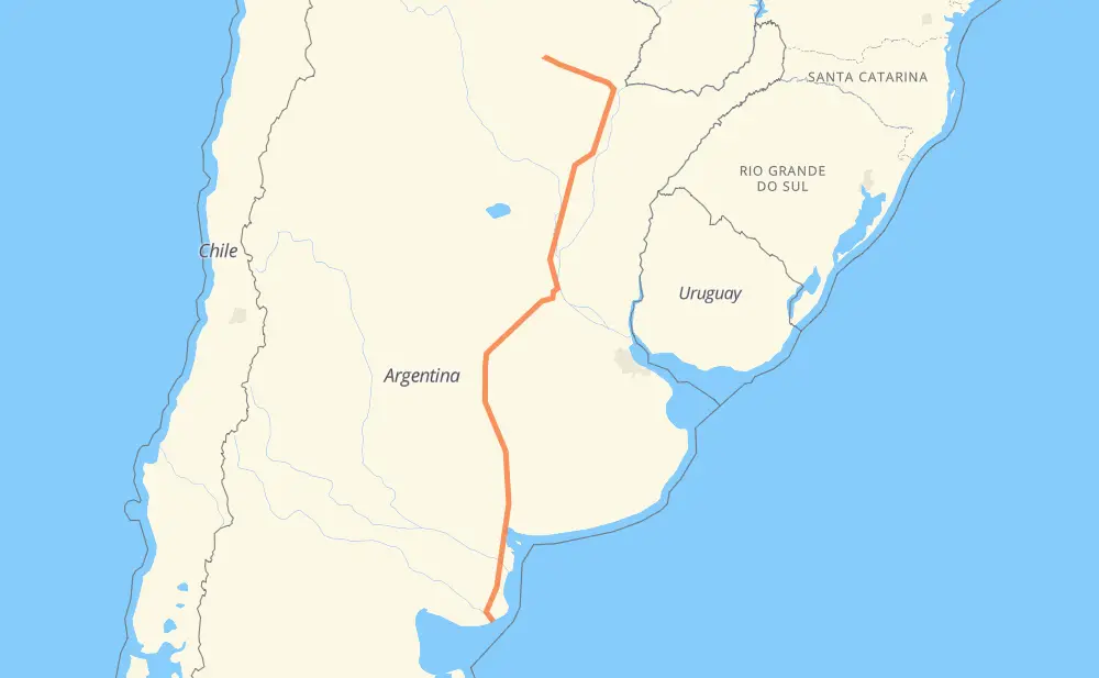
The distance from Villa 7 de Marzo to Pampa del Infierno is 2,031 kilometers by road including 161 kilometers on motorways. Road takes approximately 23 hours and 8 minutes and goes through Bahía Blanca, Resistencia, Presidencia Roque Sáenz Peña, Carmen de Patagones, Juan A. Pradere, Lago Parque "La Salada" and Villa Bordeu.
| Shortest distance by air | 1,622 km ✈️ |
| Car route length | 2,031 km 🚗 |
| Driving time | 23 h 8 min |
| Fuel amount | 162.4 L |
| Fuel cost | 240.4 GBP |
| Point | Distance | Time | Fuel | |
| Villa 7 de Marzo | 0 km | 00 min | 0.0 L | |
|
079-01 37 km, 39 min
|
||||
| Carmen de Patagones | 37 km | 39 min | 2.8 L | |
|
RN3 142 km, 1 h 29 min
|
||||
| Juan A. Pradere | 179 km | 2 h 09 min | 14.1 L | |
|
RN3 15 km, 10 min
|
||||
| Lago Parque "La Salada" | 194 km | 2 h 19 min | 15.2 L | |
|
RN3 140 km, 1 h 38 min
|
||||
| Villa Bordeu | 334 km | 3 h 57 min | 24.0 L | |
|
RN33 92 km, 1 h 05 min
|
||||
| Pigüé | 426 km | 5 h 02 min | 32.2 L | |
|
RN33 322 km, 3 h 29 min
|
||||
| General Villegas | 747 km | 8 h 32 min | 58.4 L | |
|
RN33 RN11 1,038 km, 11 h 42 min
|
||||
| Resistencia | 1,785 km | 20 h 14 min | 141.4 L | |
|
RN11 RN16 157 km, 1 h 49 min
|
||||
| Presidencia Roque Sáenz Peña | 1,942 km | 22 h 03 min | 152.6 L | |
|
RN16 88 km, 1 h 04 min
|
||||
| Pampa del Infierno | 2,031 km | 23 h 08 min | 160.4 L | |
Frequently Asked Questions
How much does it cost to drive from Villa 7 de Marzo to Pampa del Infierno?
Fuel cost: 240.4 GBP
This fuel cost is calculated as: (Route length 2,031 km / 100 km) * (Fuel consumption 8 L/100 km) * (Fuel price 1.48 GBP / L)
You can adjust fuel consumption and fuel price here.
How long is a car ride from Villa 7 de Marzo to Pampa del Infierno?
Driving time: 23 h 8 min
This time is calculated for driving at the maximum permitted speed, taking into account traffic rules restrictions.
- 147 km with a maximum speed 112 km/h = 1 h 18 min
- 6 km with a maximum speed 110 km/h = 3 min
- 2 km with a maximum speed 100 km/h = 1 min
- 1,165 km with a maximum speed 96 km/h = 12 h 8 min
- 3 km with a maximum speed 90 km/h = 1 min
- 572 km with a maximum speed 80 km/h = 7 h 8 min
- 8 km with a maximum speed 65 km/h = 7 min
- 92 km with a maximum speed 60 km/h = 1 h 31 min
- 31 km with a maximum speed 50 km/h = 37 min
- 4 km with a maximum speed 40 km/h = 5 min
- 2 km with a maximum speed 20 km/h = 4 min
The calculated driving time does not take into account intermediate stops and traffic jams.
How far is Villa 7 de Marzo to Pampa del Infierno by land?
The distance between Villa 7 de Marzo and Pampa del Infierno is 2,031 km by road including 161 km on motorways.
Precise satellite coordinates of highways were used for this calculation. The start and finish points are the centers of Villa 7 de Marzo and Pampa del Infierno respectively.
How far is Villa 7 de Marzo to Pampa del Infierno by plane?
The shortest distance (air line, as the crow flies) between Villa 7 de Marzo and Pampa del Infierno is 1,622 km.
This distance is calculated using the Haversine formula as a great-circle distance between two points on the surface of a sphere. The start and finish points are the centers of Villa 7 de Marzo and Pampa del Infierno respectively. Actual distance between airports may be different.
How many hours is Villa 7 de Marzo from Pampa del Infierno by plane?
Boeing 737 airliner needs 2 h 1 min to cover the distance of 1,622 km at a cruising speed of 800 km/h.
Small plane "Cessna 172" needs 7 h 22 min to flight this distance at average speed of 220 km/h.
This time is approximate and do not take into account takeoff and landing times, airport location and other real world factors.
How long is a helicopter ride from Villa 7 de Marzo to Pampa del Infierno?
Fast helicopter "Eurocopter AS350" or "Hughes OH-6 Cayuse" need 6 h 45 min to cover the distance of 1,622 km at a cruising speed of 240 km/h.
Popular "Robinson R44" needs 7 h 43 min to flight this distance at average speed of 210 km/h.
This time is approximate and do not take into account takeoff and landing times, aerodrome location and other real world factors.
What city is halfway between Villa 7 de Marzo and Pampa del Infierno?
The halfway point between Villa 7 de Marzo and Pampa del Infierno is Chabás. It is located about 3 km from the exact midpoint by road.
The distance from Chabás to Villa 7 de Marzo is 1,012 km and driving will take about 11 h 28 min. The road between Chabás and Pampa del Infierno has length 1,019 km and will take approximately 11 h 39 min.
The other cities located close to halfway point:
Where is Villa 7 de Marzo in relation to Pampa del Infierno?
Villa 7 de Marzo is located 1,622 km south of Pampa del Infierno.
Villa 7 de Marzo has geographic coordinates: latitude -41.03082, longitude -62.75465.
Pampa del Infierno has geographic coordinates: latitude -26.50347, longitude -61.17648.
Which highway goes from Villa 7 de Marzo to Pampa del Infierno?
The route from Villa 7 de Marzo to Pampa del Infierno follows RN33, RN11, RN3, RN16, AP01.
Other minor sections pass along the road:
- RNA012: 36 km
- 079-01: 27 km
- RNA007: 24 km
- RP85: 15 km