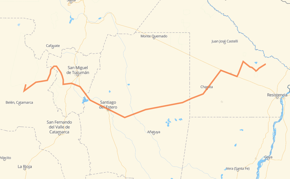
Distance between Villa Víl and General José de San Martín
The distance from Villa Víl to General José de San Martín is 1,045 kilometers by road. Road takes approximately 12 hours and 34 minutes and goes through Santiago del Estero, Presidencia Roque Sáenz Peña, Santa María, Acheral, Santa Rosa de Leales, Termas de Río Hondo and Fernández.
| Shortest distance by air | 745 km ✈️ |
| Car route length | 1,045 km 🚗 |
| Driving time | 12 h 34 min |
| Fuel amount | 83.6 L |
| Fuel cost | 124.5 GBP |
| Point | Distance | Time | Fuel | |
| Villa Víl | 0 km | 00 min | 0.0 L | |
|
RP43 RN40 146 km, 1 h 47 min
|
||||
| Santa María | 146 km | 1 h 47 min | 11.5 L | |
|
RP17 RP307 135 km, 1 h 28 min
|
||||
| Acheral | 282 km | 3 h 15 min | 21.9 L | |
|
RN38 RP323 34 km, 23 min
|
||||
| Santa Rosa de Leales | 316 km | 3 h 38 min | 24.5 L | |
|
RP323 RN9 49 km, 38 min
|
||||
| Termas de Río Hondo | 365 km | 4 h 17 min | 28.3 L | |
|
RN9 45 km, 34 min
|
||||
| Santiago del Estero | 410 km | 4 h 51 min | 30.1 L | |
|
RN9 RN34 82 km, 57 min
|
||||
| Fernández | 492 km | 5 h 48 min | 38.4 L | |
|
RN34 RN89 181 km, 2 h 11 min
|
||||
| Quimilí | 673 km | 8 h 00 min | 46.6 L | |
|
RN89 198 km, 2 h 28 min
|
||||
| Presidencia Roque Sáenz Peña | 871 km | 10 h 28 min | 68.4 L | |
|
RN16 RP9 174 km, 2 h 06 min
|
||||
| General José de San Martín | 1,045 km | 12 h 34 min | 83.3 L | |
Frequently Asked Questions
How much does it cost to drive from Villa Víl to General José de San Martín?
Fuel cost: 124.5 GBP
This fuel cost is calculated as: (Route length 1,045 km / 100 km) * (Fuel consumption 8 L/100 km) * (Fuel price 1.49 GBP / L)
You can adjust fuel consumption and fuel price here.
How long is a car ride from Villa Víl to General José de San Martín?
Driving time: 12 h 34 min
This time is calculated for driving at the maximum permitted speed, taking into account traffic rules restrictions.
- 395 km with a maximum speed 96 km/h = 4 h 6 min
- 15 km with a maximum speed 90 km/h = 9 min
- 573 km with a maximum speed 80 km/h = 7 h 9 min
- 36 km with a maximum speed 60 km/h = 36 min
- 21 km with a maximum speed 50 km/h = 25 min
- 4 km with a maximum speed 40 km/h = 6 min
The calculated driving time does not take into account intermediate stops and traffic jams.
How far is Villa Víl to General José de San Martín by land?
The distance between Villa Víl and General José de San Martín is 1,045 km by road.
Precise satellite coordinates of highways were used for this calculation. The start and finish points are the centers of Villa Víl and General José de San Martín respectively.
How far is Villa Víl to General José de San Martín by plane?
The shortest distance (air line, as the crow flies) between Villa Víl and General José de San Martín is 745 km.
This distance is calculated using the Haversine formula as a great-circle distance between two points on the surface of a sphere. The start and finish points are the centers of Villa Víl and General José de San Martín respectively. Actual distance between airports may be different.
How many hours is Villa Víl from General José de San Martín by plane?
Boeing 737 airliner needs 55 min to cover the distance of 745 km at a cruising speed of 800 km/h.
Small plane "Cessna 172" needs 3 h 23 min to flight this distance at average speed of 220 km/h.
This time is approximate and do not take into account takeoff and landing times, airport location and other real world factors.
How long is a helicopter ride from Villa Víl to General José de San Martín?
Fast helicopter "Eurocopter AS350" or "Hughes OH-6 Cayuse" need 3 h 6 min to cover the distance of 745 km at a cruising speed of 240 km/h.
Popular "Robinson R44" needs 3 h 32 min to flight this distance at average speed of 210 km/h.
This time is approximate and do not take into account takeoff and landing times, aerodrome location and other real world factors.
What city is halfway between Villa Víl and General José de San Martín?
The halfway point between Villa Víl and General José de San Martín is Fernández. It is located about 30 km from the exact midpoint by road.
The distance from Fernández to Villa Víl is 492 km and driving will take about 5 h 48 min. The road between Fernández and General José de San Martín has length 553 km and will take approximately 6 h 46 min.
The other cities located close to halfway point:
Where is Villa Víl in relation to General José de San Martín?
Villa Víl is located 745 km west of General José de San Martín.
Villa Víl has geographic coordinates: latitude -27.09385, longitude -66.82256.
General José de San Martín has geographic coordinates: latitude -26.53641, longitude -59.34149.
Which highway goes from Villa Víl to General José de San Martín?
The route from Villa Víl to General José de San Martín follows RN89, RN40, RP307, RN9.
Other minor sections pass along the road:
- RN16: 54 km
- RP9: 53 km
- RN34: 52 km
- RP4: 51 km
- RP7: 38 km
- RP323: 31 km
- RP43: 26 km
- RP36: 25 km
- RP337: 10 km
- RP17: 10 km
- RN38: 10 km
- RP51: 5 km
- RN157: 2 km