Distance between Wiarton ON and Port Aux Basques NL
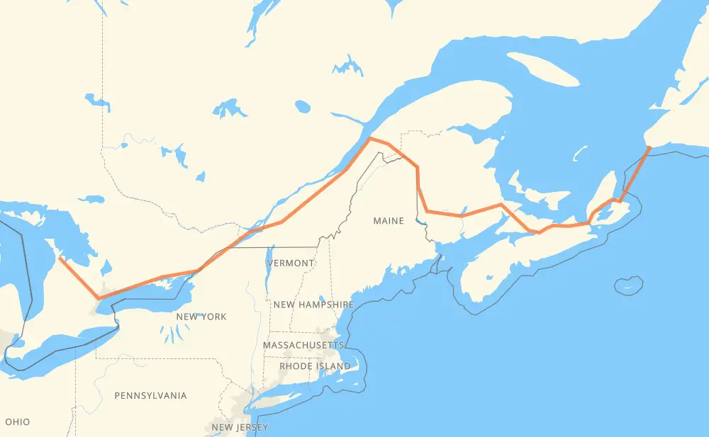
The distance from Wiarton to Port Aux Basques is 2,382 kilometers by road including 1,842 kilometers on motorways. Road takes approximately 31 hours and 14 minutes and goes through Brampton, Mississauga, Toronto, Ajax, Oshawa, Belleville and Kingston.
How much does it cost to drive from Wiarton to Port Aux Basques?
Fuel cost:
282 GBP
This fuel cost is calculated as: (Route length 2,382 km / 100 km) * (Fuel consumption 8 L/100 km) * (Fuel price 1.48 GBP / L)
You can adjust fuel consumption and fuel price here.
How long is a car ride from Wiarton to Port Aux Basques?
Driving time:
31 h 14 min
This time is calculated for driving at the maximum permitted speed, taking into account traffic rules restrictions.
678 km with a maximum speed 110 km/h = 6 h 9 min
1,124 km with a maximum speed 100 km/h = 11 h 14 min
147 km with a maximum speed 96 km/h = 1 h 32 min
44 km with a maximum speed 90 km/h = 29 min
170 km with a maximum speed 80 km/h = 2 h 7 min
31 km with a maximum speed 70 km/h = 26 min
3 km with a maximum speed 65 km/h = 2 min
3 km with a maximum speed 60 km/h = 3 min
14 km with a maximum speed 50 km/h = 16 min
177 km with a maximum speed 20 km/h = 8 h 51 min
The calculated driving time does not take into account intermediate stops and traffic jams.
How far is Wiarton to Port Aux Basques by land?
The distance between Wiarton and Port Aux Basques is 2,382 km by road including 1,842 km on motorways.
Precise satellite coordinates of highways were used for this calculation. The start and finish points are the centers of Wiarton and Port Aux Basques respectively.
How far is Wiarton to Port Aux Basques by plane?
The shortest distance (air line, as the crow flies) between Wiarton and Port Aux Basques is 1,717 km.
This distance is calculated using the Haversine formula as a great-circle distance between two points on the surface of a sphere. The start and finish points are the centers of Wiarton and Port Aux Basques respectively. Actual distance between airports may be different.
How many hours is Wiarton from Port Aux Basques by plane?
Boeing 737 airliner needs 2 h 8 min to cover the distance of 1,717 km at a cruising speed of 800 km/h.
Small plane "Cessna 172" needs 7 h 48 min to flight this distance at average speed of 220 km/h.
This time is approximate and do not take into account takeoff and landing times, airport location and other real world factors.
How long is a helicopter ride from Wiarton to Port Aux Basques?
Fast helicopter "Eurocopter AS350" or "Hughes OH-6 Cayuse" need 7 h 9 min to cover the distance of 1,717 km at a cruising speed of 240 km/h.
Popular "Robinson R44" needs 8 h 10 min to flight this distance at average speed of 210 km/h.
This time is approximate and do not take into account takeoff and landing times, aerodrome location and other real world factors.
What city is halfway between Wiarton and Port Aux Basques?
The halfway point between Wiarton and Port Aux Basques is Rivière-du-Loup. It is located about 5 km from the exact midpoint by road.
The distance from Rivière-du-Loup to Wiarton is 1,186 km and driving will take about 12 h 29 min. The road between Rivière-du-Loup and Port Aux Basques has length 1,196 km and will take approximately 18 h 44 min.
The other cities located close to halfway point:
Notre-Dame-du-Portage is in 1,180 km from Wiarton and 1,202 km from Port Aux Basques
Sainte-Hélène-de-Kamouraska is in 1,155 km from Wiarton and 1,227 km from Port Aux Basques
Saint-Pascal is in 1,148 km from Wiarton and 1,234 km from Port Aux Basques
Where is Wiarton in relation to Port Aux Basques?
Wiarton is located 1,717 km west of Port Aux Basques.
Wiarton has geographic coordinates: latitude 44.74074, longitude -81.13324.
Port Aux Basques has geographic coordinates: latitude 47.57766, longitude -59.14242.
Which highway goes from Wiarton to Port Aux Basques?
The route from Wiarton to Port Aux Basques follows TCH, 2, 401, 20, NS 104, NS 105, 10.