Distance between Birmingham and Dover
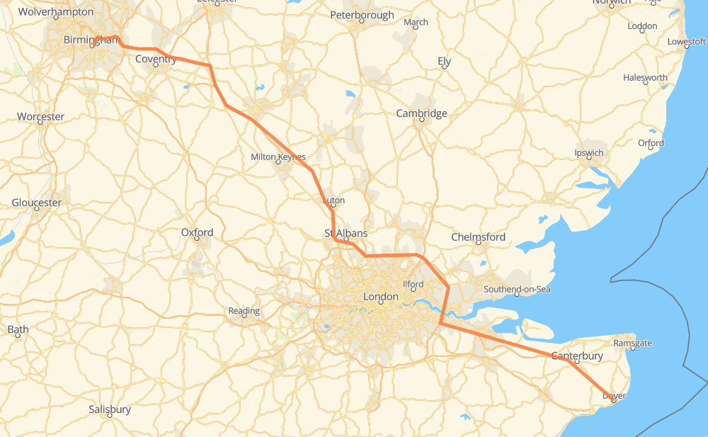
The distance from Birmingham to Dover is 320 kilometers by road including 246 kilometers on motorways. Road takes approximately 4 hours and 45 minutes and goes through St Albans, London, Poets Estate, Potters Bar, Waltham Abbey, West Thurrock and Northfleet.
| Shortest distance by air | 266 km ✈️ |
| Car route length | 320 km 🚗 |
| Driving time | 4 h 45 min |
| Fuel amount | 112.8 L |
| Fuel cost | 759.3 GBP |
| Point | Distance | Time | Fuel | |
| Birmingham | 0 km | 00 min | 0.0 L | |
|
M6 M1 104 km, 1 h 30 min
|
||||
| Poets Estate | 104 km | 1 h 30 min | 36.3 L | |
|
M1 54 km, 47 min
|
||||
| St Albans | 158 km | 2 h 17 min | 54.1 L | |
|
A414 M25 12 km, 10 min
|
||||
| Potters Bar | 169 km | 2 h 27 min | 59.5 L | |
|
M25 24 km, 20 min
|
||||
| London | 193 km | 2 h 48 min | 60.7 L | |
|
M25 28 km, 24 min
|
||||
| West Thurrock | 221 km | 3 h 12 min | 77.2 L | |
|
A282 A2 14 km, 14 min
|
||||
| Gravesend | 235 km | 3 h 26 min | 82.1 L | |
|
A2 M2 12 km, 11 min
|
||||
| Rochester | 248 km | 3 h 38 min | 86.6 L | |
|
M2 A2 72 km, 1 h 07 min
|
||||
| 51.12998, 1.30832 | 320 km | 4 h 45 min | 112.8 L | |
Hotels of Dover
Frequently Asked Questions
How much does it cost to drive from Birmingham to Dover?
Fuel cost: 759.3 GBP
This fuel cost is calculated as: (Route length 320 km / 100 km) * (Fuel consumption 35.31 L/100 km) * (Fuel price 6.73 GBP / L)
You can adjust fuel consumption and fuel price here.
How long is a car ride from Birmingham to Dover?
Driving time: 4 h 45 min
This time is calculated for driving at the maximum permitted speed, taking into account traffic rules restrictions.
- 246 km with a maximum speed 70 km/h = 3 h 31 min
- 69 km with a maximum speed 60 km/h = 1 h 9 min
- 3 km with a maximum speed 48 km/h = 4 min
- 1 km with a maximum speed 32 km/h = 1 min
The calculated driving time does not take into account intermediate stops and traffic jams.
How far is Birmingham to Dover by land?
The distance between Birmingham and Dover is 320 km by road including 246 km on motorways.
Precise satellite coordinates of highways were used for this calculation. The start and finish points are the centers of Birmingham and Dover respectively.
How far is Birmingham to Dover by plane?
The shortest distance (air line, as the crow flies) between Birmingham and Dover is 266 km.
This distance is calculated using the Haversine formula as a great-circle distance between two points on the surface of a sphere. The start and finish points are the centers of Birmingham and Dover respectively. Actual distance between airports may be different.
How many hours is Birmingham from Dover by plane?
Boeing 737 airliner needs 19 min to cover the distance of 266 km at a cruising speed of 800 km/h.
Small plane "Cessna 172" needs 1 h 12 min to flight this distance at average speed of 220 km/h.
This time is approximate and do not take into account takeoff and landing times, airport location and other real world factors.
How long is a helicopter ride from Birmingham to Dover?
Fast helicopter "Eurocopter AS350" or "Hughes OH-6 Cayuse" need 1 h 6 min to cover the distance of 266 km at a cruising speed of 240 km/h.
Popular "Robinson R44" needs 1 h 16 min to flight this distance at average speed of 210 km/h.
This time is approximate and do not take into account takeoff and landing times, aerodrome location and other real world factors.
What city is halfway between Birmingham and Dover?
The halfway point between Birmingham and Dover is St Albans. It is located about 2 km from the exact midpoint by road.
The distance from St Albans to Birmingham is 158 km and driving will take about 2 h 16 min. The road between St Albans and Dover has length 162 km and will take approximately 2 h 29 min.
The other cities located close to halfway point:
Where is Birmingham in relation to Dover?
Birmingham is located 266 km north-west of Dover.
Birmingham has geographic coordinates: latitude 52.47769, longitude -1.89485.
Dover has geographic coordinates: latitude 51.12998, longitude 1.30832.