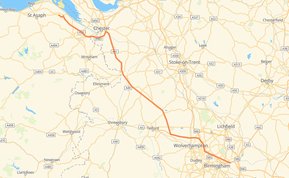
Distance between Castle Bromwich and Pantasaph
The distance from Castle Bromwich to Pantasaph is 157 kilometers by road including 38 kilometers on motorways. Road takes approximately 1 hour and 46 minutes and goes through Birmingham, Bentley, Newport, Whitchurch and Holywell.
| Shortest distance by air | 131 km ✈️ |
| Car route length | 157 km 🚗 |
| Driving time | 1 h 46 min |
| Fuel amount | 12.6 L |
| Fuel cost | 18.8 GBP |
| Point | Distance | Time | Fuel | |
| Castle Bromwich | 0 km | 00 min | 0.0 L | |
|
B4118 B4114 7 km, 06 min
|
||||
| Birmingham | 7 km | 06 min | 0.1 L | |
|
M6 7 km, 05 min
|
||||
| Great Barr | 14 km | 12 min | 1.0 L | |
|
M6 8 km, 05 min
|
||||
| Bentley | 22 km | 17 min | 1.6 L | |
|
M6 6 km, 03 min
|
||||
| Essington | 28 km | 20 min | 2.1 L | |
|
M54 31 km, 18 min
|
||||
| Newport | 59 km | 39 min | 4.6 L | |
|
A41 8 km, 04 min
|
||||
| Howle | 67 km | 44 min | 5.3 L | |
|
A41 26 km, 17 min
|
||||
| Whitchurch | 93 km | 1 h 01 min | 7.2 L | |
|
A41 A55 61 km, 40 min
|
||||
| Holywell | 154 km | 1 h 42 min | 12.3 L | |
|
B5121 4 km, 03 min
|
||||
| Pantasaph | 157 km | 1 h 46 min | 12.4 L | |
Frequently Asked Questions
How much does it cost to drive from Castle Bromwich to Pantasaph?
Fuel cost: 18.8 GBP
This fuel cost is calculated as: (Route length 157 km / 100 km) * (Fuel consumption 8 L/100 km) * (Fuel price 1.49 GBP / L)
You can adjust fuel consumption and fuel price here.
How long is a car ride from Castle Bromwich to Pantasaph?
Driving time: 1 h 46 min
This time is calculated for driving at the maximum permitted speed, taking into account traffic rules restrictions.
- 21 km with a maximum speed 112 km/h = 11 min
- 8 km with a maximum speed 100 km/h = 4 min
- 85 km with a maximum speed 96 km/h = 53 min
- 6 km with a maximum speed 80 km/h = 4 min
- 23 km with a maximum speed 80 km/h = 16 min
- 7 km with a maximum speed 64 km/h = 6 min
- 5 km with a maximum speed 50 km/h = 5 min
- 3 km with a maximum speed 48 km/h = 4 min
The calculated driving time does not take into account intermediate stops and traffic jams.
How far is Castle Bromwich to Pantasaph by land?
The distance between Castle Bromwich and Pantasaph is 157 km by road including 38 km on motorways.
Precise satellite coordinates of highways were used for this calculation. The start and finish points are the centers of Castle Bromwich and Pantasaph respectively.
How far is Castle Bromwich to Pantasaph by plane?
The shortest distance (air line, as the crow flies) between Castle Bromwich and Pantasaph is 131 km.
This distance is calculated using the Haversine formula as a great-circle distance between two points on the surface of a sphere. The start and finish points are the centers of Castle Bromwich and Pantasaph respectively. Actual distance between airports may be different.
How many hours is Castle Bromwich from Pantasaph by plane?
Boeing 737 airliner needs 9 min to cover the distance of 131 km at a cruising speed of 800 km/h.
Small plane "Cessna 172" needs 35 min to flight this distance at average speed of 220 km/h.
This time is approximate and do not take into account takeoff and landing times, airport location and other real world factors.
How long is a helicopter ride from Castle Bromwich to Pantasaph?
Fast helicopter "Eurocopter AS350" or "Hughes OH-6 Cayuse" need 32 min to cover the distance of 131 km at a cruising speed of 240 km/h.
Popular "Robinson R44" needs 37 min to flight this distance at average speed of 210 km/h.
This time is approximate and do not take into account takeoff and landing times, aerodrome location and other real world factors.
What city is halfway between Castle Bromwich and Pantasaph?
The halfway point between Castle Bromwich and Pantasaph is Tern Hill. It is located about 2 km from the exact midpoint by road.
The distance from Tern Hill to Castle Bromwich is 77 km and driving will take about 51 min. The road between Tern Hill and Pantasaph has length 81 km and will take approximately 55 min.
The other cities located close to halfway point:
Where is Castle Bromwich in relation to Pantasaph?
Castle Bromwich is located 131 km south-east of Pantasaph.
Castle Bromwich has geographic coordinates: latitude 52.50691, longitude -1.78604.
Pantasaph has geographic coordinates: latitude 53.2731, longitude -3.25936.
Which highway goes from Castle Bromwich to Pantasaph?
The route from Castle Bromwich to Pantasaph follows A41.
Other minor sections pass along the road:
- A55: 27 km
- M6: 21 km
- M54: 17 km
- A38: 2 km
- A5026: 2 km
- B5121: 1 km
- B4114: 1 km