Distance between Ciudad Juárez and Nacozari
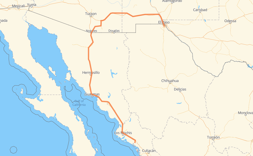
The distance from Ciudad Juárez to Nacozari is 1,442 kilometers by road including 1,179 kilometers on motorways. Road takes approximately 15 hours and 39 minutes and goes through El Paso, Heroica Nogales, Hermosillo, Navojoa, Los Mochis and Gabriel Leyva Solano.
| Shortest distance by air | 725 km ✈️ |
| Car route length | 1,442 km 🚗 |
| Driving time | 15 h 39 min |
| Fuel amount | 115.4 L |
| Fuel cost | 171.9 GBP |
| Toll roads cost | 461 + ? MXN |
| Point | Distance | Time | Fuel | |
| Ciudad Juárez | 0 km | 00 min | 0.0 L | |
|
MEX 45 15 km, 11 min
|
||||
| El Paso | 15 km | 11 min | 1.0 L | |
|
US 85 I 10 94 km, 53 min
|
||||
| Las Cruces | 109 km | 1 h 04 min | 6.2 L | |
|
I 10 68 km, 37 min
|
||||
| Deming | 177 km | 1 h 42 min | 13.8 L | |
|
I 10 392 km, 4 h 14 min
|
||||
| Heroica Nogales | 569 km | 5 h 56 min | 45.3 L | |
|
MEX 15 MEX 15D 277 km, 2 h 56 min
|
||||
| Hermosillo | 846 km | 8 h 53 min | 67.5 L | |
|
MEX 15 MEX 15D 323 km, 3 h 28 min
|
||||
| Navojoa | 1,169 km | 12 h 21 min | 93.1 L | |
|
MEX 15D 159 km, 1 h 55 min
|
||||
| Los Mochis | 1,328 km | 14 h 17 min | 106.0 L | |
|
MEX 15D 44 km, 31 min
|
||||
| Gabriel Leyva Solano | 1,372 km | 14 h 48 min | 108.8 L | |
|
MEX 15D 71 km, 50 min
|
||||
| Nacozari | 1,442 km | 15 h 39 min | 115.2 L | |
Frequently Asked Questions
How many toll booths are there from Ciudad Juárez to Nacozari?
There are 9 toll booths between Ciudad Juárez and Nacozari: Magdalena, Hermosillo, Guaymas, Libramiento Cd Obregon, Fundicion, Estacion Don La Jaula, Paso Del Norte, San Miguel and Sinaloa.
How much does the toll booths cost from Ciudad Juárez to Nacozari?
Toll roads cost: Paso Del Norte (31 MXN) + Magdalena (29 MXN) + Hermosillo (90 MXN) + Guaymas (38 MXN) + Libramiento Cd Obregon (?) + Fundicion (90 MXN) + Estacion Don La Jaula (90 MXN) + San Miguel (69 MXN) + Sinaloa (24 MXN) = 461 + ? MXN
How much does it cost to drive from Ciudad Juárez to Nacozari?
Fuel cost: 171.9 GBP
This fuel cost is calculated as: (Route length 1,442 km / 100 km) * (Fuel consumption 8 L/100 km) * (Fuel price 1.49 GBP / L)
You can adjust fuel consumption and fuel price here.
Toll roads cost: 461 + ? MXN
How long is a car ride from Ciudad Juárez to Nacozari?
Driving time: 15 h 39 min
This time is calculated for driving at the maximum permitted speed, taking into account traffic rules restrictions.
- 243 km with a maximum speed 112 km/h = 2 h 10 min
- 256 km with a maximum speed 110 km/h = 2 h 19 min
- 31 km with a maximum speed 105 km/h = 17 min
- 170 km with a maximum speed 100 km/h = 1 h 41 min
- 14 km with a maximum speed 97 km/h = 8 min
- 75 km with a maximum speed 96 km/h = 47 min
- 117 km with a maximum speed 90 km/h = 1 h 18 min
- 10 km with a maximum speed 89 km/h = 6 min
- 22 km with a maximum speed 80 km/h = 16 min
- 471 km with a maximum speed 80 km/h = 5 h 53 min
- 2 km with a maximum speed 70 km/h = 1 min
- 22 km with a maximum speed 60 km/h = 21 min
- 2 km with a maximum speed 56 km/h = 1 min
- 6 km with a maximum speed 50 km/h = 6 min
- 1 km with a maximum speed 20 km/h = 1 min
- 1 km with a maximum speed 10 km/h = 6 min
The calculated driving time does not take into account intermediate stops and traffic jams.
How far is Ciudad Juárez to Nacozari by land?
The distance between Ciudad Juárez and Nacozari is 1,442 km by road including 1,179 km on motorways.
Precise satellite coordinates of highways were used for this calculation. The start and finish points are the centers of Ciudad Juárez and Nacozari respectively.
How far is Ciudad Juárez to Nacozari by plane?
The shortest distance (air line, as the crow flies) between Ciudad Juárez and Nacozari is 725 km.
This distance is calculated using the Haversine formula as a great-circle distance between two points on the surface of a sphere. The start and finish points are the centers of Ciudad Juárez and Nacozari respectively. Actual distance between airports may be different.
How many hours is Ciudad Juárez from Nacozari by plane?
Boeing 737 airliner needs 54 min to cover the distance of 725 km at a cruising speed of 800 km/h.
Small plane "Cessna 172" needs 3 h 17 min to flight this distance at average speed of 220 km/h.
This time is approximate and do not take into account takeoff and landing times, airport location and other real world factors.
How long is a helicopter ride from Ciudad Juárez to Nacozari?
Fast helicopter "Eurocopter AS350" or "Hughes OH-6 Cayuse" need 3 h 1 min to cover the distance of 725 km at a cruising speed of 240 km/h.
Popular "Robinson R44" needs 3 h 27 min to flight this distance at average speed of 210 km/h.
This time is approximate and do not take into account takeoff and landing times, aerodrome location and other real world factors.
What city is halfway between Ciudad Juárez and Nacozari?
The halfway point between Ciudad Juárez and Nacozari is San Fernando. It is located about 2 km from the exact midpoint by road.
The distance from San Fernando to Ciudad Juárez is 719 km and driving will take about 7 h 38 min. The road between San Fernando and Nacozari has length 723 km and will take approximately 8 h 1 min.
The other cities located close to halfway point:
Where is Ciudad Juárez in relation to Nacozari?
Ciudad Juárez is located 725 km north-east of Nacozari.
Ciudad Juárez has geographic coordinates: latitude 31.65465, longitude -106.42911.
Nacozari has geographic coordinates: latitude 25.33658, longitude -108.25737.
Which highway goes from Ciudad Juárez to Nacozari?
The route from Ciudad Juárez to Nacozari follows MEX 15D, I 10, US 70, US 180.
Other minor sections pass along the road:
- AZ 82: 77 km
- MEX 15: 49 km
- MEX 2: 43 km
- US 191: 32 km
- AZ 90: 30 km
- US 85: 24 km
- Sin 240: 12 km
- Loop 375: 6 km
- MEX 15d: 3 km
- I 19 BUS: 3 km
- SR 82: 2 km