Distance between Stratfield Saye and Henley-on-Thames
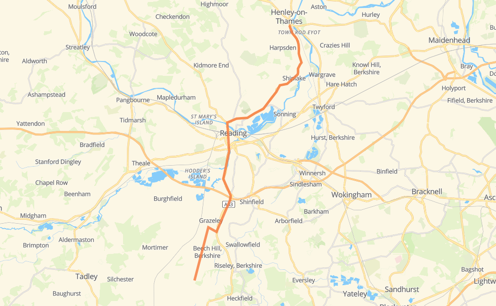
The distance from Stratfield Saye to Henley-on-Thames is 27 kilometers by road. Road takes approximately 25 minutes and goes through Coley, Beech Hill, Grazeley and Shiplake.
| Shortest distance by air | 22 km ✈️ |
| Car route length | 27 km 🚗 |
| Driving time | 25 min |
| Fuel amount | 2.2 L |
| Fuel cost | 3.3 GBP |
| Point | Distance | Time | Fuel | |
| Stratfield Saye | 0 km | 00 min | 0.0 L | |
|
1 km, 00 min
|
||||
| Fair Cross | 1 km | 00 min | 0.0 L | |
|
2 km, 01 min
|
||||
| Beech Hill | 3 km | 02 min | 0.1 L | |
|
3 km, 01 min
|
||||
| Grazeley | 6 km | 04 min | 0.4 L | |
|
A33 7 km, 06 min
|
||||
| Coley | 13 km | 10 min | 1.0 L | |
|
A33 A4155 6 km, 06 min
|
||||
| Playhatch | 19 km | 16 min | 1.5 L | |
|
A4155 3 km, 03 min
|
||||
| Shiplake | 23 km | 19 min | 1.7 L | |
|
A4155 5 km, 05 min
|
||||
| Henley-on-Thames | 27 km | 24 min | 2.0 L | |
Hotels of Henley-on-Thames
Frequently Asked Questions
How much does it cost to drive from Stratfield Saye to Henley-on-Thames?
Fuel cost: 3.3 GBP
This fuel cost is calculated as: (Route length 27 km / 100 km) * (Fuel consumption 8 L/100 km) * (Fuel price 1.49 GBP / L)
You can adjust fuel consumption and fuel price here.
How long is a car ride from Stratfield Saye to Henley-on-Thames?
Driving time: 25 min
This time is calculated for driving at the maximum permitted speed, taking into account traffic rules restrictions.
- 7 km with a maximum speed 96 km/h = 4 min
- 5 km with a maximum speed 80 km/h = 3 min
- 7 km with a maximum speed 64 km/h = 6 min
- 9 km with a maximum speed 48 km/h = 10 min
The calculated driving time does not take into account intermediate stops and traffic jams.
How far is Stratfield Saye to Henley-on-Thames by land?
The distance between Stratfield Saye and Henley-on-Thames is 27 km by road.
Precise satellite coordinates of highways were used for this calculation. The start and finish points are the centers of Stratfield Saye and Henley-on-Thames respectively.
What city is halfway between Stratfield Saye and Henley-on-Thames?
Where is Stratfield Saye in relation to Henley-on-Thames?
Stratfield Saye is located 22 km south-west of Henley-on-Thames.
Stratfield Saye has geographic coordinates: latitude 51.35166, longitude -1.01497.
Henley-on-Thames has geographic coordinates: latitude 51.53758, longitude -0.90503.
Which highway goes from Stratfield Saye to Henley-on-Thames?
The route from Stratfield Saye to Henley-on-Thames follows A4155, A33.
Other minor sections pass along the road:
- A329: 1 km